
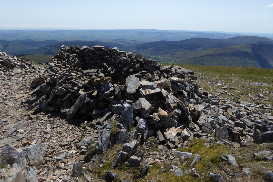
Approaching the cairn on its little knoll, centre, from the east.
Image credit: A. Brookes (16.5.2023)
Approaching the cairn on its little knoll, centre, from the east.

Looking down on the Marteg Valley from the slopes of Gamallt to the southeast. The cairn is just above and to the right of the bend in the minor road, left of centre. The hills are Moelfryn (across the hidden Gwy valley) and Yr Wylorn.

Y Gamriw fills the skyline. Seen from the ridge of high ground crossed by the Wye Valley Way to the north, above the confluence of Elan and Gwy rivers.

Landscape context from across the Gwy/Wye valley to the WSW. The ancient cairn is on top of the right-hand of the twim summits, the modern cairn on the left-hand summit.

Landscape context for the cairn on its ridge, centre skyline. Further cairns grace Trembyd to the left. The slopes of Graig Ddu (yet more cairns) rise on the right. From the Wye Valley Way near Cefn to the north.

St Gwrthwl and his stone, from the church’s information board


The enclosure top right, in a fair weather reprise of the challenging conditions from my previous struggle up here in November 2022.


Looking southeast on the cliffs of Craig y Llam across Cwm Rhwyddfor, with Pumlumon (I think) on the skyline.

Looking towards Arenig Fawr and Aran Fawddwy.


Looking towards Gau Graig from the slopes of Mynydd Moel. Aran Fawddwy rises on the skyline beyond.

Llyn Arran seen from Mynydd Moel, near the Bronze Age cairn. According to the GGAT record, the standing stone is close to the edge of the lake. Gau Graig is at the end of the mountain ridge to the right of the lake. Aran Fawddwy and the Aran mountains are on the distant skyline.

The forbidding cliffs of Mynydd Moel, seen from the ridge to the east.

The clifftop perch of the cairn. Yr Wyddfa distant skyline.


There is a serious volume of stone here. Looking towards the Tarrenau.

The wrecked cairn, shelter on the left and marker cairn on the right, both formed from the stones of the original monument.

The southwestern arc of the footprint, looking towards Pen y Gadair, the summit of Cader Idris.
The shelter built from the wreck of the cairn. Pumlumon (I think) on the distant skyline.

Mynydd Moel from the cliffs to the west. The summit is marked by a rocky outcrop with a cairn on it (top right), but as a result the Bronze Age cairn is out of sight from this angle, interestingly.

Llyn Gafr below the towering cliffs of Cader Idris, seen from Mynydd Moel.

The settlement is to the right of the smaller lake (the larger lake is Lyn y Gadair). Elevated view from Pen y Gadair. Yr Wyddfa distant centre skyline.

Carnedd Lwyd just to the left of centre, over the plunging cliffs of Cyfrwy. Barmouth and the Mawddach estuary can just be seen beyond, with the hills of the Llyn floating on the horizon. From Pen y Gadair, the summit of Cader Idris.

The view from above Bwlch Cau to the north that few of the visitors to Pen y Gadair seem to seek out, just me and some sheep on an otherwise busy day. Looking towards Craig Cwm Amarch, with the softer peaks of the Tarrenau hills beyond.

Looking down on the lake from Craig Cwm Amarch to the west.

Llyn Cau in its mountain cradle, from the path up to Craig Lwyd.

A contrast to my previous visit in filthy November weather, the quartz boulder in Spring splendour with bluebells.


The football pitch is behind, but sadly the team has folded following Covid-suspension of the league.

Looking northwest towards Garth and the Elenydd uplands.


Landscape context and a retrospective of the previous image; the cairn is in the sunlit field in the centre of the shot, with sheep. The hill rising on the left skyline is Gilwern Hill (stone circle and cairns). Afon Gwy lies between and below, out of sight of the cairn.


Looking northwest. The rising ground on the skyline is the eastern edge of the Elenydd uplands.

There’s plenty of stone showing through the nettles.

From the west. The monument isn’t particularly enhanced by the rusting bail sledge.

Looking out over the Dyfi valley towards Pumlumon.


The eastern cairn, of questionable prehistoric provenance, is on the top of the hill in the centre. Seen across Llyn Barfog.

Remains of orthostatic kerb on the western cairn.


The top of the western cairn, looking towards Trum Gelli and the Tarrenau.

The western cairn, looking towards Llyn Barfog.