Image credit: Robert Gladstone

Exterior of eastern arc......

To the south...

Eastern arc (approx)

Southwestern arc, looking to the south

Exterior of part of the eastern arc...

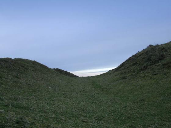
Eastern flank, looking south(ish). Again, very impressive.

Western flank, looking approx south. Impressive.

Approaching from the north-west, it doesn’t appear much... for a few seconds.

Open Source Environment agency LIDAR

Got this pic from the roadside. I don’t think there is any public access.
Looks like it could do with a trim!

This Neolithic henge is just of the A30 near Bodmin.
Truly an enthusiasts site.
The only other Cornish henge I know of is at Castlewich in East Cornwall.
A circle-henge, would you believe?
A previously unknown stone circle has been found inside a Cornwall scheduled monument, a conservation group says.
The underground circle has been found inside Castilly Henge, near Bodmin, by Historic England (HE) and the Cornwall Archaeology Unit.
It was found during the site’s first modern archaeological survey to better understand the area, HE said.
The site has now been fenced, allowing it to be grazed by animals without damaging the structure, it added.
The henge is one of 40 scheduled monuments protected by the Cornwall Area of Outstanding Natural Beauty.
Details of henge on Pastscape
(SX 0310 6275) Earthwork (NR) (1)
`Castilly` (name probably derived from `Castel), an oval earthwork with internal ditch, and entrances on north and south, the latter recognisably not original. Variously described by early writers as a castle or a Plain-an-gwarry (amphitheatre for religious plays), but thought from its form to be a Class I henge. Excavated by Charles Thomas and the Cornish Arch Soc in 1962. The excavation (in cental area and at the two entrances) produced very little dating material – two flint flakes and two pottery pieces of probably 12 – 14 c date. It was shown that the southern entrance was secondary and the northern original, though overlaid with gravel in which were deep wheel-marks.
The ditches lacked the expected amount of silting. It was concluded that there was a Class I Henge in the first place, and that this had been remodelled as a Plain-an-gwarry in medieval times. Probably also the work had been used as a gun emplacement in the Civil War (which would explain the wheel-ruts in the north entrance), with perhaps further modification. (2)
SX 03116274. The henge which is 70.0 metres by 60.0 metres is situated on a slight north slope with the entrance on the downhill side and a gap on the S uphill side. The internal ditch is up to 1.7 metres deep and well defined; a narrow berm separates it from the bank. The average height of the bank is 1.4 metres above ground level and it has been mutilated in places especially on the north-west and south sides (the latter by a field hedge). Resurveyed at 1:2500. (3) (SX 031 627) Included in gazetteer and distribution map Neolithic Site in Cornwall. (4)
Castilly. Sub-oval enclosure. Listed by Harding and Lee as a possible henge. (5)
One of only three surviving henges in Cornwall, along with Castlewich Henge and the Stripple Stones. This is what Craig Weatherhill says in his book ‘Cornovia: Ancient Sites of Cornwall’ (Cornwall Books, 1985, revised 1997 & 2000):
“Above the W side of the A391, just S of its junction with the A30. The site is clearly visible from the A30. An oval earthwork with a maximum diameter of 66m. The surrounding bank is 1.8m high; the internal ditch is 2.1m deep and 5.5m wide. The flat featureless central area measures 49m by 29m. The broad opening on the north-west side is the original entrance; the smaller south-eastern gap dates from about the thirteenth century when the site was remodelled for use as a plen-an-gwary (medieval amphitheatre). It was adapted again, this time for defensive purposes, during the Civil War. The henge, recognised as such in 1954, was excavated in 1962 but its Neolithic origin was not conclusively proved. Sited on a north-facing slope, it lies near the junction of two major prehistoric trackways and was formerly surrounded by several round barrows, few of which remain.”
This site was first noted by Borlase in 1871 as a “Plain an Gwarry” (a medieval open air theatre.)
An excavation showed the site was dug into weathered slate.
Features suggest it was much earlier than medieval and it seems reasonable to assume it is a henge.
5 or more barrows are recorded nearby.