6/8/04- the blocked passage with the rabbit skeletons
6/8/04- the blocked passage with the rabbit skeletons

6/8/04- one of the massive roof lintels

6/8/04- just inside

6/8/04- the unroofed section before the present entrance

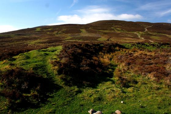
6/8/04- the entrance under the dry stane dyke

6/8/04- the corner of the field
Friday 6/8/04
Driving way up a tiny country road (and I use the word ‘road’ in its loosest possible meaning- put it this way there’s grass growing up trhough the remains of the red tar in the middle of it!) I meet a friendly old man out for his walk in his wellies. I stop to ask him about the souterrain of Wester Yardhouses and if it is okay for me to visit and take some pictures, ‘aye, nae bother’! Turns out this guy is a font of local knowledge regarding antiquarian sites. He tells me about Scottish Water doing some work up on the hill next to one of the cairns and unearthing a massive stone but not really realising what they were doing! He also tells me of an old friend of his who stayed nearby, now long gone, who, every year, used to clean 13 old boundary stones that crossed the Pentlands. We make our separate ways and I head across to the corner of a lonely field of Lanarkshire. Under a dry stane syke, a hole. A muddy entrance 86 cm wide by 1 m high. However, this wouldn’t have been the original entrance as an unroofed section runs about 2.75 m EW before this. I put my hard hat and boiler suit on and crawl inside. The mud floor of the souterrain rises up for about 2.5 m and then falls away, but it has been deliberately blocked only about 4.5 metres from the present entrance. At the very end are a couple of piles of rabbit bones and skulls. There are still some massive lintels to be seen in the short passageway, one being about 1 m wide by 1.5 m long. I take some pictures, write these notes and head back to the car under a grey sky with nothing but the cry of buzzards overhead.
Description from RCAHMS 1978;
This souterrain lies on the crest of a low ridge 168m NNW of Wester Yardhouses farmhouse and under the foundations of a modern field wall. The passage has recently been deliberately blocked 4.6m from the entrance and the outer section reconstructed.
Excavations in 1923 (A Fairbairn 1924) revealed that from the entrance, which faced E, the passage ran westwards for 2.0m, then NNW for a distance of 2.7m, and finally W again for a further 7.2m. The width of the passage varied from 0.9m to 1.7m. The walls were corbelled and rose to a height of 1.5m at the point where they were spanned by the only surviving lintel-stone. In the two outer sections of the passage the basal course was formed by particularly massive stones, the largest measuring 1.9m in length and 0.4m in depth, but in the innermost section the lowest course consisted of large flagstones set on edge. The entrance was flanked by two portal stones, and another pair stood at the junction of the central and innermost sections of the passage. At the W end, where the souterrain was at its widest, traces of burning were found on the clay floor. The finds, which are in the National Museum of Antiquities of Scotland (NMAS), comprised chert and flint flakes, several scraps of hand-made pottery of indeterminate date, a block of ‘red pigment’ and fragments of medieval pottery.
Flint arrowheads have been picked up locally, and one perfect barbed and tanged specimen was found close to the entrance some years ago.