Visited 23th May 2015
Image credit: Uwe Häberle 05/2015
Visited 23th May 2015

Visited 23th May 2015

Visited 23th May 2015

Visited 23th May 2015

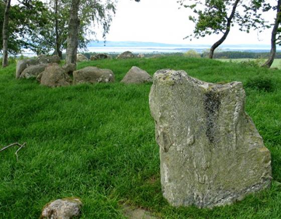
The SW arc of stones with a couple of the displaced central stones in front.

Detail of stones within the ring.

Detail of the egg-shaped stones of the western arc.

From the west, showing how the stones are graded with the largest on the SW arc.

From the northwest.

Raigmore cairn circle from the southeast.

Lovely bone toggle from the cairn, in Inverness Museum.

Food vessel (front) and cremation urn, recovered from Stoneyfield cairn. On display in Inverness museum.

Pieces of Neolithic pottery from the Stoneyfield cairn. On display in Inverness Museum.


E half.

W half.
Visited 21 April 2012. Tucked away in the outskirts of Inverness, this seems something of a well-kept secret. Situated immediately north of the city’s Raigmore Hospital, in a small area of greenery next to a little babbling beck (or should that be babbling burn?), the cairn is not in its original position. Surrounded on all sides by buildings and tarmac, the ambience is lacking.
Despite all this, it’s difficult not to be taken with this fine circle of stone. The stones appear to be graded, with the largest in the SW of the ring, very like the ruined near-neighbour at Culduthel. The largest stones have a lovely egg-shape, something they share with another nearby site, Torbreck. There are a few “loose” stones in the centre of the ring, which I can only assume were faithfully re-positioned in this way when the circle was moved wholesale from its original location. It definitely has what Burl might describe as “Clava affinities”, although it lacks any outer free-standing stone circle.
I spend about 15 miuntes here, getting puzzled looks from the frequent passers-by on their way home from work. I imagine many people pass this way without giving any thought to what this circle is. As is often the case with an urban site, it’s difficult to get much of a sense of place, especially knowing it’s been moved, but nevertheless it retains a certain something, perhaps arising from its stubborn survival against pretty steep odds.
Definitely worth the (minimal) effort of a visit. Superb finds from the site, including a couple of welll-preserved urns, can be seen on display in Inverness’ excellent Musuem.
Nice kerb cairn with large closely set stones looking better than it did when I last saw it 10 years ago. Then it was only about one quarter visible due to untamed vegetation. Now, thanks probably to further building development in the area, it sits in clear open ground.
The site is not in its original location but was moved when the Kessock Bridge approach road was built.
It was once thought to be a Clava ring cairn, largely on account of the grading of stones towards the SW. However excavation prior to its relocation revealed no inner kerb.
Behind the Community Centre, Ashton Road in the Raigmore Estate, Inverness.
7.6.05
Canmore description, including finds:
At Stoneyfield are the remains of a Clava-type cairn. All that remains is the major part of an impressive cairn kerb, 58’ indiameter. The cairn itself and the internal structure have been removed, though when seen by Anderson (J Anderson 1831) in about 1824 the cairn seems to have been fairly complete. The stones forming the kerb are massive boulders, the largest being on the SW arc – the tallest, a leaning stone at the S end of this arc, 4’9” high – and other stones are 4’6” to 4’3” high. The stones in the NE arc are 1’9” to 2’9” high. Many stones have fallen inwards or outwards but have not been disturbed, and several have been reduced by blasting. There is no sign, nor it there any record, of monoliths which may once have surrounded the cairn.
In 1760 two stone circles were recorded at Stoneyfield. (a, b) (This feature was first published on OS 6"map as “Stone Circle”).
A S Henshall 1963; R Pococke 1887; New Statistical Account (NSA, A Rose, A Clark and R Macpherson) 1845, G Anderson 1831; J Fraser 1884; Visited by OS (W D J) 30 March 1960.
Later finds from this cairn, excavated in 1972 and 1973, included a 2nd century Roman brooch and a sherd of coarse ware.
D D A Simpson 1973, 1974.
The excavation of this cairn in 1972-3 revealed that beneath it there had been a rectangular timber building, 9.5m long with a central stone hearth, probably associated with a series of pits containing Grooved Ware. The cairn itself consisted of a heavy stone kerb with traces of
an external stone platform on the W; in the central area there was a series of pits and cists, some of them contemporary with the cairn, some later. Several of the pits contained cremations, and in one of the cists there was a Food Vessel. A Cordoned Urn with a cremation had also been deposited in the cairn. Other articles found included a cup-marked stone, a 2nd century Roman brooch, and a sherd of coarse ware.
A S Henshall 1963; D D A Simpson 1973, 1974; RCAHMS 1979.
The kerb of this cairn was re-erected at NH 6878 4508 in advance of a new road, which now occupies the original site.
Resurveyed at 1:1250.
Visited by OS 26 January 1979.
Extensive Report into this site, diagrams, pictures and much more