
23/12/2017 – A soggy top
23/12/2017 – A soggy top
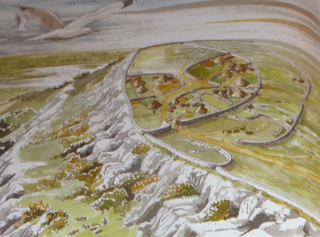
Artist interpretation.

Looking towards the village of Warton from the top if the crag

Jan 2012

The hill viewed from afar

Outcrop on the summit where the fort is located.

The Natural Defenses of Warton Crag

Outcrop on Warton Crag

Ugly modern Cairn next Prehistoric one on the very Summit of Warton Crag.
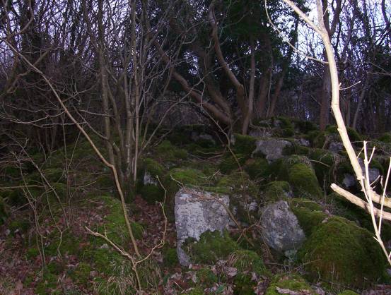
Close up detail of inner rampart.

The inner rampart.

Standing Stone on the inner Rampart.
23/12/2017 – Proper rubbish weather visit to Warton Crag. Low mist and fine rain. Didn’t really find too much of the hillfort and it was just too wet for me to be bothered looking about much. Just a quick up and down to the trigpoint really.
We started and finished our walk at Carnforth train station (lovely tea room). Quiteish roads to Warton and then a lovely climb up through a wood to the top. Nice rocky bits as well. I guess on a hot summer’s day this would be a lovely place to be.
Overall I did enjoy my visit even if my time spent at the fort was just a brief encounter :-)
Visited January 2012. It is very hard to get a real feel for this site due to the tree cover but it is very, very flat at the top and there are stones littered everywhere. I have enver visited in summer but assume it is even harder to make any real sense of the remains. What is astonishing though are the views from here – across to Ingleborough in the east and Morecambe Bay & the Lakeland hills to the west.
There are a number of routes to the top, but the easiest and most interesting is through Strickland Woods (as described below by Hob). Definitely worth a walk up here on a clear, sunny day.
More of a fortlet really, worth a visit more for the view and the ambience, than for any great remains. I visited here in summer 1994, and (assuming the intervening years have been kind) the remains of the fort are still covered with trees, and the ramparts are still visible in places. The area was littered with stones that may have been bits of the fort. It definitely affords excellent views over the sands, with the southern lakes hovering in the background.
If you go to visit the three brothers,
( themodernantiquarian.com/site/80 )
the fort is easily reached from the bridleway, through Strickland Wood. However the path involves rough woodland surfaces, not suitable for those of limited mobility. The area is a nature reserve, noted for it’s unusual lepidoptera, so tread extra careful.
“It is believed that the entire summit of Warton Crag was once a fort, built by the Brigantes (an early British tribe) in the 1st century AD, making use of the defences provided by the natural rock formation. The path crosses the remains of semi-circular ramparts which can just be traced within the woodland to the north of the summit. The fort evidently gave Warton its name, meaning the turn (town) by the Weard (a watch place, or look-out)”
From
(which also gives very detailed directions for the walker)
The summit of the Crag has a commanding view over Morecambe Bay and vessels approaching the sea entrance to Leighton Moss could be spotted immediately from here. On the northern and eastern sides of the summit – and really difficult to make out – are the remains of three stone-built ramparts which make up a small fort. Thought for a long time to be Iron Age, archaeologists more recently have been divided about it’s origins. Some have suggested it could be older – perhaps Neolithic or Bronze Age – while others have noted a similarity with post-Roman defensive settlements elsewhere in Britain. As with Summerhouse Hill, eighteenth-century antiquarians report the excavation of burial mounds on the skirts of Warton Crag’ in which human remains and earthenware beakers were found.
Walking around the moss and exploring the surrounding hills, the impression gained is that this was an important area for prehistoric peoples. The woods, the marshy fringes of the bay and the seashore itself were clearly valuable sources of food and materials.
The hills provided sites to bury their dead and possibly somewhere where religious ceremonies and celebrations were held. The summit of Warton Crag meanwhile has been a safe haven for many generations of local people: a look-out post to spot the arrival of threatening newcomers and a fortress to retreat into in the event of attack.
Leighton Moss Ice Age To Present Day by Andy Denwood (Published 2014)
Just to the west, down the hill from the three brothers and the fort, are the caves known as the dog holes. I couldn’t find these, but subsequently found that evidence of burial, possibly
romano-british was excavated here.
Gives references for the dog holes caves about one third of the way down the page.


