The southeastern arc of the earthwork curves across the image towards the right (honestly!).
Image credit: A. Brookes (1.5.2021)
The southeastern arc of the earthwork curves across the image towards the right (honestly!).

Looking east. The low remains of the bank and ditch head away from the camera before curving across to the centre left.

Looking along the “ditch” – the SE quadrant.

The raised remains of Condicote Henge is more pronounced on the north side as (I hope) this picture demostrates through the bushes. As seen on 25 August 2006 CE.

It is difficult to photograph this henge as much of it has been ploughed-out over the years. In this photo the right hand side of the grass is part of the raised henge arching round towards the left of the picture. As seen on 25 August 2006 CE.

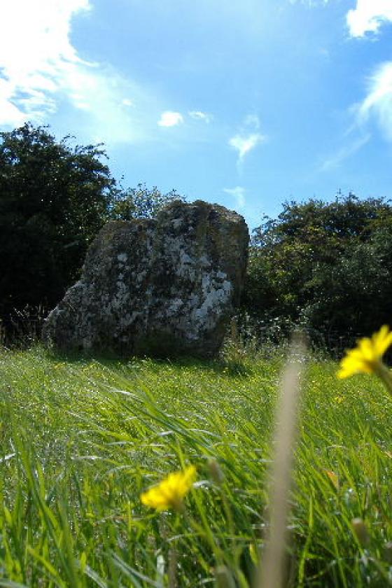
This is the best shot that I could get of the bank of Condicote Henge.

See that band of darker grass running through the centre of this pic? Well, that`s all that`s left of the bank of Condicote Henge. The road, which I`m standing on to take this photo, runs through the centre of the henge.
A revisit on an overcast May day while walking the Gloucestershire Way from Stow-on-the-Wold to Winchcombe (1.5.2021). In contrast to the lovely warmth of the previous weekend’s walk, a cold wind is blowing across the wolds today, and rain is threatening to arrive from the east.
It’s been over a decade since I last came here, less than the blink of an eye for the henge. Last time I came, the southern part of the henge was accessible through a little pedestrian gate from the village hall. Sadly the gate is now locked, possibly a reaction to the ongoing pandemic, although it’s pretty unlikely that anyone will catch Covid in an empty field. The road runs right through the middle of the earthwork, but this ain’t no Avebury! The dull weather makes photographing the almost-gone earthwork from the road even less easy than before.
I content myself with sitting on a bench and having a snack, on the edge of where the henge once was. It’s a survivor, but only just. A rarity in Gloucestershire, so worthy of the revisit for that novelty. Onwards!
Visited 6.3.2009 on a walk from Stow on the Wold, via Lower and Upper Swell and Pole’s Wood. The henge is very low, to the point of almost non-existence. To the west is the village hall, which has a parking area. The southern part of the henge is in a field used by the locals for dog walking and accessed from the village hall car park.
The sun was out and I stopped here for lunch, as well as to recover from the nerve-jangling shooting at Pole’s Wood South. From here I walked back to Stow along the valley of the Dikler river.
Details of henge on Pastscape
A sub-circular henge monument defined by two concentric ditches with a bank between them. The monument survives partly as earthworks and partly as cropmarks. The internal diameter of the bank is circa 112 metres, thus enclosing around 0.9 hectares. The presence and location of entrances is uncertain, with parts of the bank, ditches and interior obscured by buildings and a minor road. Watching briefs were undertaken in 1938 (roadside water main) and 1952-3 (building operations) confirmed the presence of internal and external ditches but failed to recover any dating evidence. Two small areas within the henge were excavated in 1977 in advance of building work, and a section dug across the inner ditch. The interior cotnained recent and natural features, although some flint flakes were found in the upper fills of some of the latter. The inner ditch was near vertical-sided, flat-bottomed, and measured 4.2 metres wide and 2.4 metres deep below modern ground level. The ditch fill included pottery (possibly Beaker), animal bones, charcoal and burnt stones, much of it apparently representing a deliberate act of deposition from the henge interior. Two radiocarbon dates were obtained from charcoal and burnt wood, both falling in the 18th century bc (uncalibrated), suggesting the possibility of a later Neolithic origin. Roman pottery came from the upper fill (and a single Iron Age sherd hade been reported on an earlier occasion). A watching brief in 1991 observed only modern finds, while another in 1992 along the course of the Condicote to Lasborough Sewer noted pit-like features immediately northwest of the henge in a geophysical survey. In addition, short irregular linear features adjacent to the bank on the west side were suggested to represent the remnants of a discontinuous outer ditch mirroring the more complete outer ditch visible on the east side.
Excavations at Condicote Henge by A.Saville 1977