The Modern Antiquarian
Log in
|
Register
Home
Latest Posts
Forums
Maps
Help
Browse Sites
News
Blog
Contributors
The Books
Select
-
Belgium
Denmark
Eire
France
Germany
Greece
Italy
The Netherlands
Norway
Portugal
Republic of Malta
Spain
Sweden
Switzerland
United Kingdom
England
Southern England
Dorset
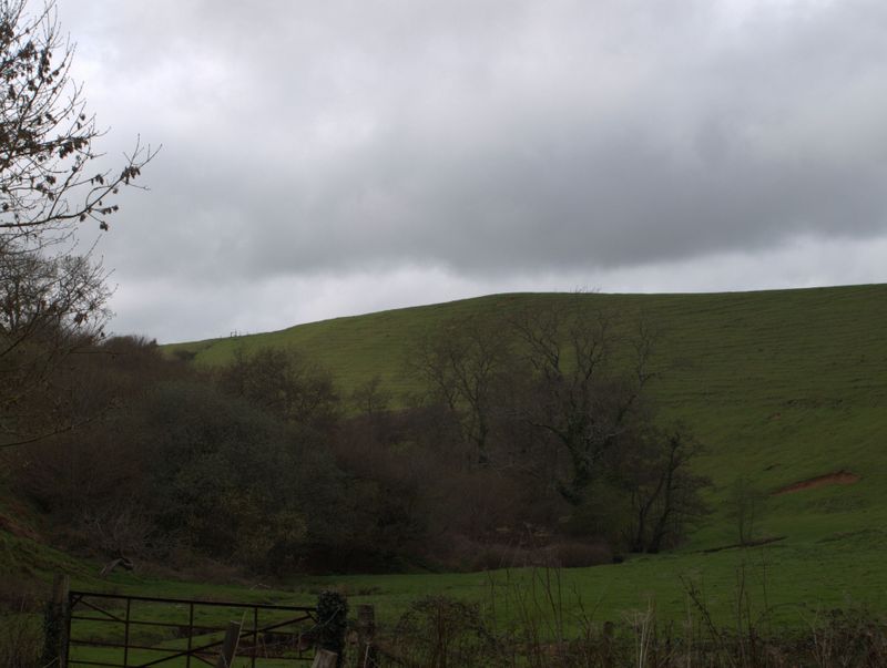
Burcombe Hill
Hillfort
Burcombe Hill (Hillfort) on The Modern Antiquarian, the UK & Ireland's most popular megalithic community website. 1 image, 1 fieldnote, plus information on many more ancient sites nearby and across the UK & Ireland.
Image © Mike Rowland 23/01/2024
Nearest Town:
Bridport (8km SSW)
OS Ref (GB):
SY5117998843 /
Sheet: 194
Latitude:
50° 47' 11.46" N
Longitude:
2° 41' 33.55" W
Added by
formicaant
Images (1)
Fieldnotes (1)
0 discussions
Start a topic
Show |
Hide
Web searches for Burcombe Hill
Flickr
Google
Google Images
MAGIC
The Megalithic Portal
Bing
Stone Pages
Streetmap.co.uk
Wikipedia
Show map
(inline Google Map)
- Sites within 20 km -
-
Powerstock Common (3.47km E) (4 posts)
Toller Porcorum Churchyard (4.86km E) (4 posts)
Eggardon Hill (5.12km ESE) (42 posts)
Bradpole (5.31km SW) (2 posts)
Eggardon Barrows (5.49km ESE) (13 posts)
Corscombe (5.95km N) (8 posts)
South Eggardon Farm (5.98km SE) (1 post)
Two Gates (6.06km ESE) (2 posts)
West Compton Down (6.57km ESE) (6 posts)
Shipton Hill (6.75km S) (10 posts)
Chilcombe Hill (7.08km SE) (6 posts)
Askerswell (7.22km SE) (3 posts)
Wynford Eagle (7.53km E) (6 posts)
Hammiton Hill (7.6km S) (4 posts)
Shipton Gorge (7.6km S) (4 posts)
Barrow East of Two Gates (7.63km ESE) (2 posts)
Lewesdon Hill (7.82km W) (12 posts)
The Castle (Cattistock) (8.32km ENE) (2 posts)
Evershot (8.73km NE) (6 posts)
North Hill (8.76km SSW) (2 posts)
Norden Hill (8.8km ENE) (2 posts)
Colmer's Hill (8.82km SW) (3 posts)
Pin Knoll (8.83km SE) (2 posts)
North Barn Farm (9.37km ESE) (2 posts)
The Helstone (9.54km ESE) (11 posts)
Eype Down (9.67km SW) (3 posts)
Long Bredy (9.71km ESE) (28 posts)
Martin's Down Long Barrow (10km ESE) (11 posts)
Bind Barrow (10.1km S) (5 posts)
Pilsdon Pen (10.1km W) (45 posts)
Kingston Russell Cursus (10.16km ESE) (1 post)
Thorncombe Beacon (10.45km SW) (7 posts)
Hangman's Rocks (10.56km ESE) (1 post)
Black Down (Kingston Russell) (10.9km ESE) (10 posts)
Field Barn (10.97km ESE) (4 posts)
Doghouse Hill (10.97km SW) (5 posts)
Hog Cliff Hill (11.09km E) (3 posts)
Winterbourne Poor Lot (11.13km ESE) (29 posts)
Peak End Hill (11.17km ENE) (3 posts)
Puncknowle (11.29km SSE) (4 posts)
Hardown Hill (11.42km WSW) (5 posts)
The Broad Stone (11.9km ESE) (19 posts)
Three Barrow Clump (12.04km ESE) (5 posts)
Limekiln Hill (12.34km SE) (4 posts)
Kingston Russell Barrow (12.37km SE) (5 posts)
Golden Cap (12.38km WSW) (16 posts)
Tenants Hill (12.47km SE) (5 posts)
Tulk's Hill (12.48km SE) (10 posts)
Little Bredy (12.51km ESE) (2 posts)
Old Warren (12.6km ESE) (6 posts)
The Nine Stones of Winterbourne Abbas (12.85km ESE) (109 posts)
Kingston Russell (12.86km SE) (101 posts)
Abbotsbury Castle (13.01km SE) (19 posts)
Pigeon House (13.12km E) (2 posts)
Longlands (13.24km ESE) (5 posts)
Big Wood (13.24km ESE) (18 posts)
Valley of Stones Barrow (13.25km ESE) (1 post)
The Wishing Stone (13.52km ENE) (7 posts)
Wears Hill (13.57km SE) (7 posts)
Sheep Down (13.66km ESE) (6 posts)
Crow Hill (13.67km ESE) (3 posts)
Winterbourne Steepleton Cromlech (13.69km ESE) (6 posts)
Grimstone Down (13.69km E) (10 posts)
Pound Hill (13.69km ESE) (4 posts)
The Grey Mare & Her Colts (13.77km SE) (62 posts)
Grimstone Down Barrows (13.77km E) (2 posts)
Sheep Down Long Barrow (13.91km ESE) (6 posts)
Yetminster Stone (13.94km NE) (3 posts)
Coney's Castle (14km WSW) (19 posts)
Lambert's Castle (14.03km W) (18 posts)
Red Barn (14.09km E) (3 posts)
Sheep Down Enclosure (14.1km ESE) (5 posts)
White Hill Barrows (14.12km SE) (13 posts)
The Valley of Stones (14.23km ESE) (34 posts)
Furzey Down Road (14.25km E) (1 post)
Smacam Down (14.38km ENE) (2 posts)
Smacam Down Long Barrow (14.51km ENE) (1 post)
Portesham Hill Long Barrow (14.64km ESE) (2 posts)
Penn Hill (14.94km E) (11 posts)
Hampton Down (15km ESE) (48 posts)
Bishop's Limekiln (15.05km SE) (4 posts)
Rew Lane (15.06km ESE) (5 posts)
Winterborne St Martin Disc Barrow (15.07km ESE) (1 post)
Black Down (Portesham) (15.11km ESE) (36 posts)
Portesham Standing Stones (15.16km ESE) (1 post)
The Hellstone (15.28km ESE) (101 posts)
Chapel Hill (15.3km SE) (13 posts)
Third Milestone Barrow Cemetery (15.62km E) (2 posts)
Cerne Abbas Giant (15.71km ENE) (47 posts)
The Trendle (Cerne Abbas) (15.71km ENE) (3 posts)
Bronkham Hill (16.14km ESE) (21 posts)
Purlands Farm (16.24km E) (7 posts)
Dogbury Hill (16.26km ENE) (5 posts)
Grove Hill (16.43km ESE) (3 posts)
Whitfield Farm (17.1km E) (6 posts)
Great Hill Barrows (17.35km ESE) (5 posts)
Clandon Barrow (17.42km ESE) (11 posts)
Ridge Hill (17.47km ENE) (1 post)
Whitfield (17.48km E) (3 posts)
Wood Hill (17.53km E) (2 posts)
Four Barrow Hill (17.61km ESE) (9 posts)
Hamdon Hill (17.89km NNW) (25 posts)
Lanceborough King Barrow (18.17km E) (15 posts)
Maiden Castle Long Barrow (18.29km E) (5 posts)
Maiden Castle Round Barrow (18.57km ESE) (2 posts)
Wolfeton Clump (18.62km E) (4 posts)
Poundbury Hillfort (18.7km E) (34 posts)
Ridge Hill (18.74km ESE) (15 posts)
Maiden Castle Bank Barrow (18.79km E) (1 post)
Maiden Castle (Dorchester) (18.91km E) (94 posts)
Friar Waddon (18.96km ESE) (9 posts)
Gould's Hill Barrows (19.43km ESE) (22 posts)
Dungeon Hill (19.71km ENE) (14 posts)
Dorchester Palisaded Enclosure (19.76km E) (4 posts)
Maumbury Rings (19.88km E) (49 posts)
Fidler's Green (19.9km E) (2 posts)
- Facilities within 20 km -
-
The Anchor Inn (Pub: 11.6 km SW)
The Kings Arms (Pub: 15.9 km SE)
Portesham Dairy Farm C... (Camping Site: 16.1 km SE)
The Dorset County Museum (Museum: 19.8 km ESE)
- Add -
-
Add news
Add an image
Add fieldnotes
Add folklore
Add miscellaneous
Add a link
-
Add a site
Add a nearby facility
Add an alternative name/spelling
Images
(click to view fullsize)
Add an image
Fieldnotes
Add fieldnotes
There is scant information about this site, there are banks and ditches which enclose around an acre. It is triangular in shape and is described as a defensive enclosure. Dates are estimated to be from the Iron age to the Medieval period.
Comments (3)
|
Add a comment
|
Permalink
Posted by
formicaant
23rd January 2024ce
Edited 23rd January 2024ce

 Posted by formicaant