The Modern Antiquarian
Log in
|
Register
Home
Latest Posts
Forums
Maps
Help
Browse Sites
News
Blog
Contributors
The Books
Select
-
Belgium
Denmark
Eire
France
Germany
Greece
Italy
The Netherlands
Norway
Portugal
Republic of Malta
Spain
Sweden
Switzerland
United Kingdom
Scotland
Highland (Mainland)
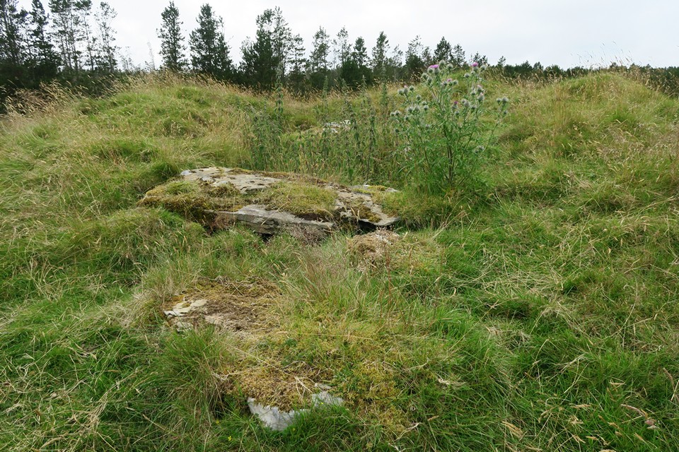
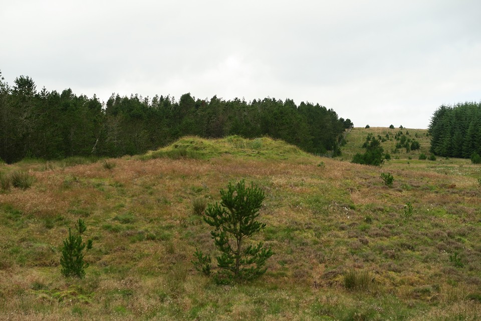
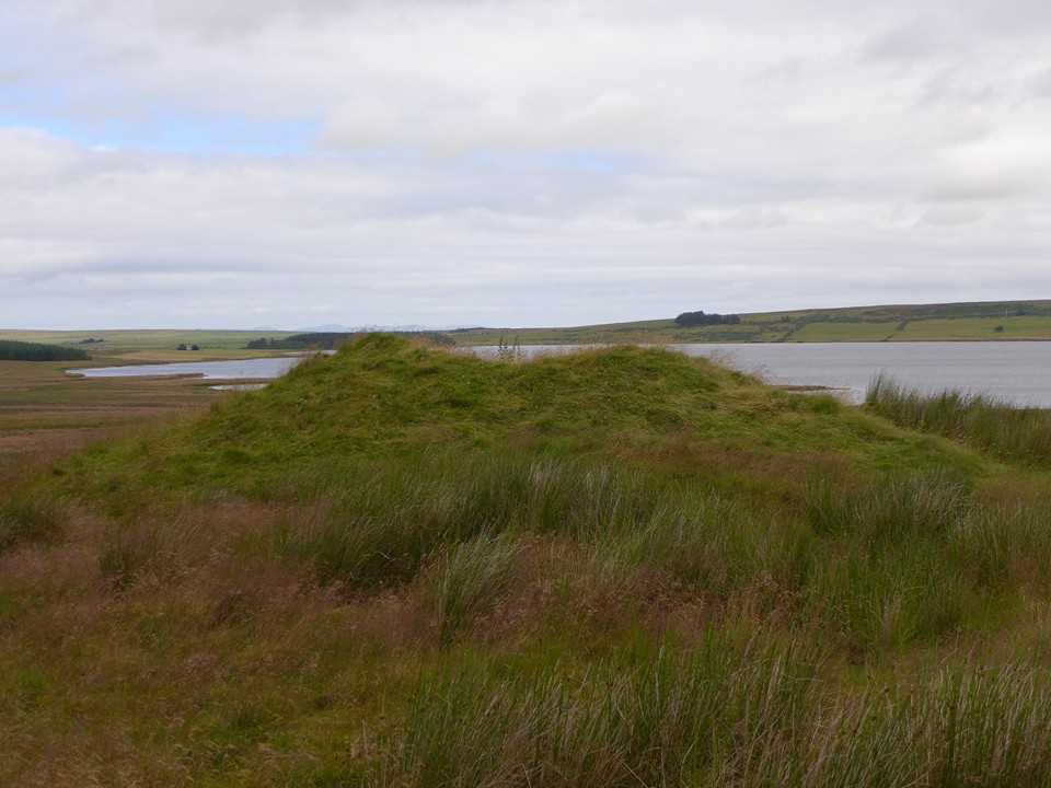
Torr Ban Na Gruagaich
Chambered Cairn
Torr Ban Na Gruagaich (Chambered Cairn) on The Modern Antiquarian, the UK & Ireland's most popular megalithic community website. 4 images, 1 fieldnote, plus information on many more ancient sites nearby and across the UK & Ireland.
Image © thelonious
Nearest Town:
Thurso (10km NNE)
OS Ref (GB):
ND05856001 /
Sheets: 11, 12
Latitude:
58° 31' 5.91" N
Longitude:
3° 36' 59.36" W
Added by
thelonious
Images (4)
Fieldnotes (1)
0 discussions
Start a topic
Show |
Hide
Web searches for Torr Ban Na Gruagaich
Flickr
Google
Google Images
MAGIC
The Megalithic Portal
Bing
Stone Pages
Streetmap.co.uk
Wikipedia
Show map
(inline Google Map)
- Sites within 20 km -
-
Torr Ban Na Gruagaich (0.18km ENE) (1 post)
Tulach Buaile Assery (0.21km WNW) (7 posts)
Port-an-eilein (0.71km S) (2 posts)
Bridge of Broubster (1.03km W) (4 posts)
Carriside (1.04km E) (1 post)
Aultan Broubster (1.35km WSW) (6 posts)
Broubster (1.38km W) (6 posts)
Carriside (1.55km E) (5 posts)
Shurrery Kirk (1.85km SW) (2 posts)
Shurrey, Sithean Dubh (1.88km SSW) (3 posts)
Tulloch of Assery (2.09km NNE) (10 posts)
Carn Liath, Shurrery (2.65km SW) (5 posts)
Dorrery (3.57km SE) (5 posts)
Torr Mor (3.63km SSE) (2 posts)
Torr Beag (3.84km SSE) (9 posts)
Balnabeinn Hut Circle (3.97km SSE) (4 posts)
Torr Phadruig (4.1km SE) (6 posts)
Ben Freiceadain (4.21km SSE) (14 posts)
Ben Freiceadain (4.31km SSE) (12 posts)
Dorrery (4.93km SE) (8 posts)
Ben Dorrery (5.01km SSE) (4 posts)
Hill of Shebster (6.53km WNW) (14 posts)
The Sian (6.66km WNW) (1 post)
Cnoc Freiceadain (7.01km WNW) (28 posts)
Cnoc Freiceadain N (7.33km WNW) (8 posts)
Clach Clais An Tuirc (7.37km W) (2 posts)
Creag Bhreac Mhor (7.53km WNW) (1 post)
Upper Dounray (7.97km WNW) (1 post)
Achvarasdal (7.99km W) (11 posts)
Thing's Va (8.46km NNE) (9 posts)
Gallow Hill North (9.46km ENE) (4 posts)
Gallow Hill (9.55km ENE) (8 posts)
Sordale Hill (9.57km ENE) (6 posts)
Cnoc Urray (9.73km WNW) (1 post)
Cnoc Na H-uiseig (9.84km WNW) (2 posts)
Cnoc na Ciste (10.02km ENE) (6 posts)
Tulach Lochain Bhraseil (10.53km ESE) (4 posts)
Tulach an Fhuarain (10.53km ESE) (2 posts)
Tulach Buaile a'Chroic (10.77km ESE) (6 posts)
Bell Mount (10.89km NNE) (2 posts)
Sinclair's Sithean (10.93km ENE) (7 posts)
Carn na Mairg (Carn Merk) (11.61km ESE) (11 posts)
Sysa (11.96km ENE) (3 posts)
Holburn Head (12.54km NNE) (9 posts)
Ballone, Mybster (12.56km E) (5 posts)
Dirlot (13.11km ESE) (5 posts)
Tulach Beag (13.37km ESE) (5 posts)
Tormsdale Stone Rows (13.62km ESE) (1 post)
Tulach Mor (13.83km ESE) (12 posts)
East Murkle (14.38km NE) (1 post)
Stone Lud (Bower) (16.27km ENE) (3 posts)
Upper Bighouse (16.97km WSW) (0 posts)
Loch Mor (17.22km W) (0 posts)
Backlass (17.76km SSE) (5 posts)
Trantlemore (17.85km WSW) (4 posts)
Carn Liath, Farr (18.11km WSW) (5 posts)
The Borg (18.26km WSW) (15 posts)
Links of Greenland (18.39km ENE) (3 posts)
Links Of Dunnet (18.9km ENE) (4 posts)
Rangag West (19.15km ESE) (11 posts)
Dunnet (19.18km ENE) (2 posts)
Watten (19.36km E) (7 posts)
- Add -
-
Add news
Add an image
Add fieldnotes
Add folklore
Add miscellaneous
Add a link
-
Add a site
Add a nearby facility
Add an alternative name/spelling
Images
(click to view fullsize)
Add an image
Fieldnotes
Add fieldnotes
01/08/2016 - I liked this one. Good location, overlooking Loch Calder. Similar to Tulach Buaile Assery chambered cairn nearby. A fine couple of cairns, well worth the walk.
Comments (0)
|
Add a comment
|
Permalink
Posted by
thelonious
7th August 2016ce


 Posted by thelonious