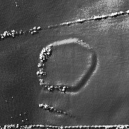
The Modern Antiquarian
Log in
|
Register
Home
Latest Posts
Forums
Maps
Help
Browse Sites
News
Blog
Contributors
The Books
Select
-
Belgium
Denmark
Eire
France
Germany
Greece
Italy
The Netherlands
Norway
Portugal
Republic of Malta
Spain
Sweden
Switzerland
United Kingdom
England
Southern England
Devon
Voley Castle
Hillfort
Voley Castle (Hillfort) on The Modern Antiquarian, the UK & Ireland's most popular megalithic community website. 1 image, plus information on many more ancient sites nearby and across the UK & Ireland.
Image © © Environment Agency copyright and/or database right 2015.
Nearest Town:
Lynton (7km ENE)
OS Ref (GB):
SS6552146561 /
Sheet: 180
Latitude:
51° 12' 6.66" N
Longitude:
3° 55' 30.4" W
Added by
ginger tt
Images (1)
0 discussions
Start a topic
Show |
Hide
Web searches for Voley Castle
Flickr
Google
Google Images
MAGIC
The Megalithic Portal
Bing
Stone Pages
Streetmap.co.uk
Wikipedia
Show map
(inline Google Map)
- Sites within 20 km -
-
Beacon Castle (0.98km E) (0 posts)
Paracombe Lane (2.24km E) (3 posts)
Woolhanger Henge (4.02km E) (2 posts)
Stone near Roe Barrow (4.67km E) (1 post)
Broken Barrow (4.93km SSE) (2 posts)
Chapman Barrows (5.29km ESE) (3 posts)
Hangman's Stone (Combe Martin) (5.31km W) (1 post)
Pixie Rocks (5.6km ESE) (1 post)
Mattocks Down (6.02km WSW) (7 posts)
The Longstone (Exmoor) (6.1km ESE) (9 posts)
Longstone Barrow (6.44km ESE) (3 posts)
Longstone Stone Setting (6.56km ESE) (1 post)
Ilkerton Ridge Stone (6.77km E) (1 post)
Lyn Long Stones (7.21km ENE) (2 posts)
Woodbarrow (7.37km E) (2 posts)
Hoaroak (8.82km E) (1 post)
Countisbury Castle (8.89km ENE) (1 post)
Shoulsbury Castle (9.01km ESE) (6 posts)
Berrynarbor (9.11km WSW) (1 post)
Chains Barrow (9.17km E) (1 post)
Cunnilear Camp (10.55km SSW) (0 posts)
Clannon Ball Stone Setting (10.76km E) (3 posts)
Setta Barrow (11.01km ESE) (4 posts)
High Bray no. 9 (11.29km ESE) (1 post)
Muxworthy Ridge (11.42km ESE) (6 posts)
Ricksy Ball Stone (11.42km ESE) (1 post)
Brendon Two Gates (W) (11.42km E) (3 posts)
Squallacombe I, II and III (11.73km ESE) (3 posts)
Hoccombe Hill West (11.86km E) (3 posts)
Rexy Barrow (12.34km E) (1 post)
Five Barrows (12.39km ESE) (11 posts)
Hillsborough (12.41km W) (1 post)
Roman Lode (12.79km ESE) (1 post)
Hoccombe Hill East (12.92km E) (4 posts)
Lanacombe stones (13.05km E) (1 post)
Badgworthy Lees Stone (13.34km E) (1 post)
Lanacombe 4 (13.51km E) (1 post)
Drybridge Combe Stone (13.56km ESE) (1 post)
Hangley Cleave (13.75km ESE) (6 posts)
Halscombe Stones (14.05km ESE) (1 post)
Manor Allotment stone setting (14.89km E) (1 post)
Longcombe Burrow (15.19km E) (1 post)
Swap Hill Stone (15.44km E) (1 post)
Stowey Allotment Stone (15.72km E) (1 post)
Whitestone, Lee Bay (15.87km WSW) (1 post)
Long Holcombe Stone (15.88km ESE) (1 post)
Horsen Hill Stones (16.32km E) (1 post)
Cow Castle (16.58km E) (8 posts)
Quarter Barrow (17.23km ENE) (1 post)
Elsworthy (17.3km E) (1 post)
Lark Barrow (17.46km E) (1 post)
Culbone Stone (17.63km ENE) (6 posts)
Culbone Hill (17.63km ENE) (7 posts)
Sherdon Barrows (17.63km ESE) (2 posts)
Black Barrow (17.78km E) (1 post)
Bremridge Wood (17.82km SSE) (0 posts)
Damage Barton (18.26km WSW) (5 posts)
Alderman's Barrow (18.58km E) (4 posts)
Porlock Stone Circle (18.9km E) (17 posts)
Porlock Stone Row (19.11km E) (4 posts)
Almsworthy Stone Circle (19.43km E) (8 posts)
Whit Stones (19.71km ENE) (7 posts)
Brightworthy Barrows (19.83km ESE) (2 posts)
- Facilities within 20 km -
-
Museum of Barnstaple (Museum: 16.8 km SSW)
- Add -
-
Add news
Add an image
Add fieldnotes
Add folklore
Add miscellaneous
Add a link
-
Add a site
Add a nearby facility
Add an alternative name/spelling
Images
(click to view fullsize)
Add an image