
Across the chamber looking out through the portals, blinded by the light.
Image credit: ryaner
Across the chamber looking out through the portals, blinded by the light.

The back of the tomb.

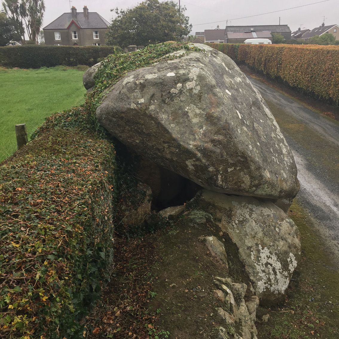
Up a lane at the back of a supermarket in Kilkeel is this.

From this angle it looks like it is trying to scamper over the wall, maybe to get away from the locals...

Most, if not all, of the main stones are still extant, though the capstone may have slipped somewhat.

Looking south.
Looking north.

The rear of the tomb.


View of Slieve Binnian (747m) from the Schlager Household
The Crawtree Stone, Kilkeel
This LITTLE Cromlech, in Kilkeel town, is one of the few in the Kingdom of Mourne to have survived from the hands of the granite stone workers over the years. Not sure as yet how & why it came to be known as The Crawtree Stone, this Smurfer is cute & worth a visit.
Access from Newcastle Street. First out of the town centre, heading of course towards Newcastle, there’s access to a lane on the left just past the mini-roundabout. Just dander up the lane & it’s on the left side in the ditch, or should I say the ditch was built to meet it on both sides....ya’ll know what I mean when ya see it.
The portal single-chambered grave, with it’s entrance pillars, measures about 1.5 x 1.5m. The rounded granite cap-stone is about 2.8m in diameter and rises to a height of 2.5m above ground level.
The Mountains of Mourne, Co. Down – Area Overview
First of my notes on my Homeland (promise).
I’ve been meaning to get around to contributing for a while, considering that I was born and breed in the area (before settling in Bayern, Deutschland) & have started on the research trail. First an overview of this proud & beautiful Kingdom.
These wild steep-sided granite hills, made famous the world over in a Percey French song (...“where the Mountains of Mourne sweep down to the sea”) present an unforgettable aspect. They reach to an average height of about 600m and are largely inaccessable except with a good pair of walking boots, the ring road & one road through the Deers Meadow right in the middle of it all.
Get yerself 1 map... OS of Northern Ireland „Mourne Country – Outdoor Pursuits Map, ISBN 1-873819-07-2. It’s got all ya need a easy to pick up in bookshops in Kilkeel, Warrenpoint or Newcastle.
Lots of sites of interest in the area – from Antiquarian (eg. Kilfeaghan Dolmen with it’s 40 ton cap-stone) through to the early Church & the Norman’s ( Greencastle Castle 1260 CE ) – if ya’ll feel like getting/stayin’ fit it’s got some of the top Hill Walks in Ireland.
So if ya want to explore the Mourne area, i’d recommend that you stay in Carlingford Town, which is just over the County Louth, a day is needed for this place alone. Amazing seafood ....plus 2 castles, Royal Mint, most of the ancient town walls, 2 ancient Churches, lots of character & to top it off the best view of the Mournes....EVER!
Rostrover village is another good option, very charming & bloody great pubs. But don’t stay in Newcastle, it’s the main tourist centre & very tacky, however the beach & Murlough National Nature Reserve do deserve a visit.
The highest mountain in the Mournes & Ulster is Slieve Donard ( 852 m) – safe & easy climb & on a good day you’ll get a view of what looks like the whole of Ireland, West Scotland, Wales, Cumbria, etc.
At one time the mountains were a remote and ungovernable area inhabited by smugglers, now it’s just windsweep & very rugged farmers who you won’t understand as the old Mourne spek ( as we call it ) is absolutly crazy. Theirs hundreds & thousands of miles of ancient tracks going in all directions through open moorland and upland pastures, which make excellent walking country. The upper sections of the Mounrne Mountains are all characterised by wee fields with dry-stone walls – a custom which remains very strong to this day. Check out the Mourne Wall, it’s the largest, 35km long and 2m high, which encloses the water catchment of Silent Valley.
Slán
S


