|
|
|
|
Crichton SouterrainSouterrain
|
|
|
|
Images (click to view fullsize) |
|
Photographs:


 Maps / Plans / Diagrams:
 Artistic / Interpretive:
|
Fieldnotes |
|
|
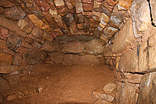
3pm Sunday 8 November 2009 The hedges along the tiny single lane B road were full of rusty orange beech leaves and crimson hawthorn berries. Myself and Samspade parked at the gate at the bottom of the field. A low winter sun strafed the stubble in the fields. The souterrain field has a crop of winter greens this year. This meant a longer walk along the field to the left side then up until we were level with the fenced in overgrown patch in the middle of the field. The souterrain's in there. We made our way across the crops along a tractor wheel rut to avoid trampling the crop. Samspade had never been before and was looking forward to seeing this site. I'd been many times and had brought waterproof trousers, wellies, a torch and my wee camera. This souterrain can be very wet and the crawl/ crouch on the way in can leave you caked in Midlothian glaur. True to form, the floor was a sea of muddy water and squelching clay. Despite the damp and the hanging "bead curtains" of dripping wet grass roots Samspade was gobsmacked at the place and we walked around taking pictures and soaking in the quiet still calm of this unique place. Samspade picked up a beautiful flint scraper from the edge of a puddle. The first lintel upon entering the souterrain is covered with many cup marks (one is huge). We wondered if it had previously been a standing stone nearby which had been re-used. The other huge lintel stones could well have been standing stones too, for although there is evidence of working/ shaping on some of them, their shapes seem in marked contrast to the neatly squared and dressed roman blocks in the walls. Perhaps originally the "Pegasus" was a bit of roman graffitti on a standing stone? When we finally crawled out blinking in the last rays of the afternoon, the view out over the Firth of Forth was spectacular. The twin peaks of Fife's Lomond Hills sat high above the trail of smoke from Kirkcaldy. The strange hillock two fields below was illuminated by the dying rays of the sun making it look even more unnatural. We rounded the day off with a trip to a garden centre to pick up bark chips for Samspade's garden. The centre was full of Christmas tack. We bought a bag of bark and left as quickly as we could, trying not to let the tacky tinsel and glitter outshine the quiet gloom of the souterrain. |
 Posted by Howburn Digger
9th November 2009ce Edited 10th November 2009ce |
|
Crichton Mains Souterrain Winter 1990 I first found out about this place after one of my mates had sold his camper van to a guy who was into battle re-enactments and who had a local historical knowledge. So- on one of our mad Sunday afternoon outings we all piled out here. We knew it was in a field somewhere east of Crichton village and under some pylons. Luckily, the time of the year we visited the field was kinda bare and the big grassy clump gave the spot away. We strode out across the field with much gusto and determination completely oblivious to actually owned it! The entrance is really small and low- but the chamber itself is about 15 m long in the form of an arc with the ceiling about 2 m high. This structure has a great number of Roman dressed blocks that were used in its constriction and one of the ceiling lintels still has a rough Pegasus carved on it (the emblem of Legio II Augusta). It's though that the material possibly came from an adjacent military Roman road-post. Anyways- we all piled into the structure and were sitting in the quiet darkness soaking up the atmosphere when all of a sudden a thunderstorm broke overhead. We all took one look at each other and clambered out as fast as possible- I've never since seen half a dozen grown men move so fast! PS- be sure to visit Crichton Castle at NT380612- a cracker! Directions From Edinburgh head south-east to Dalkeith. Take the A68 out of Dalkeith to Pathhead, then the B6367 on the right. Go through Crichton (blink and you'll miss it!) and take the next road left. The souterrain is in the field on the right past the small woods and under the pylons. Be sure and ask permission at one of the farms-not sure which- woops! |
Posted by Martin 15th December 2001ce |
Links |
|
Crichton MainsNMRS-file, including a nice series of b-w photographs, in the RCAHMS's Canmore Database. |
 Posted by rockartuk
23rd February 2010ce Edited 23rd February 2010ce |

