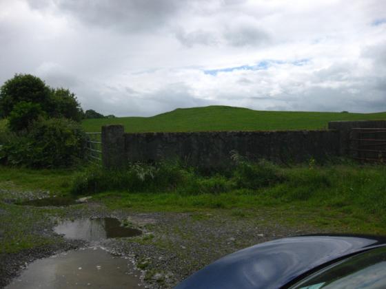
The central, burial(?) part of the barrow.
Image credit: ryaner
The central, burial(?) part of the barrow.

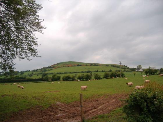
Looking west onto the barrow.

I’ve passed this way on many an occasion and never noticed this. It’s right at the edge of the map too, between sheets 48 and 49.

Just over the hedge on the old N6 Dublin to Galway road.
From archaeology.ie:
Class: Barrow – unclassified
Townland: PASS OF KILBRIDE
Scheduled for inclusion in the next revision of the RMP: Yes
Description: On a prominent hillock with good views to the N, E and S. Possible ringfort (WM034-005----) 350m to SE. A small roughly circular flat-topped, mound (diam. 5.2m N-S; 6.3m E-W; H c. 1.3m) defined by a scarp with slight narrow fosse (Wth 1.6m; D 0.2m) around the base of the mound best preserved from W-N-E, not visible at S. Traces of a very slight depression visible on the centre of the mound.
Monument surveyed in 2015 and described by McGuinness (2015, 60-3) as following: ‘Monument comprises a roughly square-shaped mound with rounded corners (8.5m NNW-SSE x 9.2m WSW-ENE), flat top (5m N-S x 5.2m E-W) and steeply sloping sides, delimited by a shallow ditch formed of four straight lines (Overall dims. 11.5m NNW-SSE x 13m ENE-WSW), the corners sunken deeper than the channels connecting them as if the ends overlapped; possibly these represent pits or hollows left by decayed timber posts. Mound is oriented ENE-WSW (NE-SW), being higher and more massive at SW end; ditch is slightly trapezoidal in shape, the SW end measuring 11.9m in length while the NE end measures only 10.4m. Where highest at SW, mound rises 1.26m above ditch. Ditch appears to be best preserved on W side, where a thorn tree growing from side of mound arches over it; here it is up to 0.16m below external ground level. Ditch at E side appears at least as deep but is densely overgrown and inaccessible; ditch is very poorly preserved on S side. Ditch ranges in width from 1.6m at well-preserved W side up to 1.8m at N side. Immediately Beyond ditch on W side is what appears to be a low external bank—as this is by no means certain, maximum dimensions for the monument given above are derived from the ditch This barrow, marked ‘Moateen’ on OS 6” map, is strikingly positioned on flat summit of S end of low but very prominent glacial hillock with long axis running N-S, just N of the N6; and, but for vegetation, there would be good views in all directions. A raised bog visible only a short distance to N has been harvested for peat on an industrial scale, as have other raised bogs to S. This hillock is at N edge of the pass or strip of dry land that gives the townland its name—less than 1km across at this point—which runs E-W between areas of bog that have been an impediment to movement since prehistoric times: a remarkable cluster of ancient trackways has been discovered in the bogs to the S, the nearest cluster being c. 1km to SSE (WM034-009----/010---/01-2----/014----/015----), including one (WM034-014----) that has been radiocarbondated to 1390-1046 cal. BC, placing it around the junction of Middle and Late Bronze Age. The ASI document a possible ringfort (WM034-005----) about 350m to SE. Although not yet examined by the survey-team, a ‘motte’ (WM034-003----) lying immediately S of the N6 c. 700m to WSW of the present site could, from the ASI account given on the NMS website, be interpreted as a bowl-barrow, perhaps with stepped or otherwise shaped summit like those at Slane More and elsewhere in Ireland (McGuinness 2012, 12-13): Steep-sided mound (H 2m), there is a low rise on the centre of the summit, the significance of which is unclear. At the base of the motte from NE-E-S-W to WNW there is a wide shallow fosse. No visible trace of a bailey…. Traces of linear earthworks in field to the SW are visible on Bing Maps…. [and] could be the remains of a medieval road associated with the motte. [NMS website]. Monument lies between two ruined medieval parish churches on sites which Leo Swan (1988, 13, 21) attributed to the early medieval period: Pass of Kilbride, with St Bridget’s Well (WM034-001----/002----), only c. 700m to W but not certainly of early medieval date; and Clonfad, 2.5km to ENE, with a ruined medieval church, standing stone, early medieval high cross (Crawford 1927, 1-2) and a burial ground, including ‘the bishop’s grave’, surrounded by sub-circular earthworks representing the enclosing monastic vallum (WM027-066----/067----). The unusual rectilinear earthwork described here is not obviously a barrow, and indeed, as one ASI fieldworker observed on 8/6/71, ‘It does not appear to belong to any of the known classes of antiquity in Ireland’ [SMR file]. Nonetheless, it is a flat-topped mound surrounded by a ditch, which—angularity of plan aside—are features found in other Westmeath barrows; it is very strikingly located on a glacial hillock with excellent visibility, a type of location common for barrows in this and other counties; and the recognition of a second, prominently sited rectilinear barrow (WM027-027----) only c. 8km to NE seems to suggest that it is indeed a barrow, albeit of a hitherto unknown type in Ireland’.
Compiled by: Caimin O’Brien based on details provided by David McGuinness.
Date of upload: 10 February 2016