
Into the Empty Quarter — Drosgl and the Berau 18 April 2013
Uneventful train journey over (why is it always raining in Stafford?), the road is hit with much enthusiasm. Today Postman and I are heading to the western Carneddau, the range’s empty quarter now, although once people lived and loved and died in the high valleys, millennia past or just yesterday, depending on your perspective of Time.
I’m nervously excited about the walk ahead, easily the biggest test of my slow-mending leg and within sight of where that happened last summer. But the pull – or is it a push? – is too great to ignore, as ever. We park up at the end of a series of prosaically named streets (Short Street, Long Street, Hill Street) in Gerlan, just uphill from Bethesda. Stepping out of the car, the wind is keen and promises to offer a stiff challenge to our progress.
The first section of the route takes us steadily uphill, past a very ruined settlement with views of Moel Faban, then across muddy fields to Tan-y-Garth, the first and last homely house we’ll come to for a good long time today.
Moel Faban from Tan-y-Garth above Bethesda.

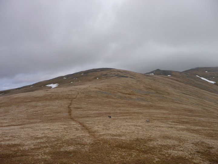
Moel y Ci (centre) from Y Garth on the way up to Drosgl. The Sling burial chamber is situated in the lower ground to the right of the picture.
From there it’s a matter of picking a random route up to Y Garth, where the views open out beautifully. Cwm Caseg lies below us, with the western Glyderau rising spectacularly to our south, shapely peaks marred by the enormous workings of Penrhyn slate quarries. The high Carneddau are hidden away in cloud, their slopes still clad in the last remnants of recent snow, but our first target, Gyrn Wigau, is a tantalising grassy slog away. Bearings got, we make a start on the biggest climb of the day.
It’s a tiring climb up the grassy slopes, not helped by a succession of false crests that keep the top from us – luckily the strong wind is at our backs to push us up the final climb. I’ll be honest, I wasn’t expecting much from this first summit, on the map it appears very much a trivial subsidiary of Drosgl. The reality proves immensely better, once it finally comes into sight. A long ridge, lying at right angles to our route, each end of which is topped with a lovely natural cheval-de-frise of mini-pinnacles. From the northern end of the ridge there is a fine view of Moel Wnion, with the sea beyond. The wind up here is absurd, constantly threatening to knock us over. Postie reckons it’s not as bad as it was on Foel Grach last year – we’ll see. Drosgl awaits.

Moel Wnion (with conical Gyrn to the left) seen from Gyrn Wigau to the south.

The obvious notch of Bwlch ym Mhwll-le (centre), with Moel Faban (left) and Llefn (right), seen from the summit of Gyrn Wigau. The cairns are to the right of the notch.

Becairned Foel Grach (left) and cloud-wreathed Carnedd Llewelyn rise above Cwm Caseg. Seen from Gyrn Wigau to the northwest.
The two ponies show us the way to Drosgl, seen from Gyrn Wigau. The larger summit cairn can be seen on the left (the pointy one on the right is modern). Bera Bach and Carnedd Uchaf rise beyond.
A rather narrow and meandering path heads up the slopes of Drosgl from Gyrn Wigau, fairly gentle at first then steepening after we cross a footpath running up from the direction of Moel Wnion. Rounding the shoulder of the mountain it becomes obvious that the path will not take us up to the summit, so we head off and upwards over increasingly rocky terrain. The wind that has been at our backs so far now blows across our route, trying to steer us off course and making progress difficult. At length we make it up onto the rounded summit plateau. The main prehistoric cairn here is enormous. As Gladman notes, it doesn’t crown the summit itself (that honour being left to a pointy modern effort) but instead turns its face to the northern panorama. The vista is awe-inspiring, the wonderful Ynys Mon to the northeast, with Moel Wnion in the foreground. To the north the sea stretches away, and there is a fine view of Llwytmor to the northwest with the Orme in the distance beyond. At our backs, the highest Carneddau tops drift in and out of the clouds. Oh yeah.
Just a few metres north is a smaller cairn (apparently restored after excavation) with a neat kerb of larger blocks. Plenty of suitable material to choose from on this entirely rocky summit. It’s interesting to ponder the relationship between the two cairns and the people who were lain to rest in them. Were they contemporaries? Or did hundreds of years separate their interments? Only the wind might know the answer, but it’s speaking in a language we don’t understand.
We sit in what little shelter we can find, contemplating the next move. My leg feels okay, and the rocky tops of Bera Mawr and Bera Bach look sooo close. Happily Postie is up for an extension of our walk to take them in, so we leave the cairns and head off the top. It’s a blessed relief to get out of the wind as we descend the eastern slopes to the boggy col below.

The massive summit cairn, looking SSW. Carnedd Dafydd emerging from cloud on the left, Moel Eilio far right, western Glyderau out of sight behind the cairn.

The really very impressive main summit cairn.

The main cairn, looking west. Moel y Ci, with its own cairn, is the dark hill far below, far left. Ynys Mon lies across the Menai Straight, right skyline.

The smaller kerbed cairn, looking NE. Llwytmor Bach is the ridge on the far right. Beyond that rise the hills above Penmaenmawr, the general vicinity of the Druid’s Circle complex.

The kerbed cairn, looking north out to sea.
Crossing a patch of resolutely frozen snow, my foot breaks through the crust into a void below, dropping me fully up to my thigh into nothingness. Woah. Care is clearly needed up here. Bera Mawr (“Big Ricks”) is crowned with a tor of superb rock pinnacles, with two natural monoliths reminiscent of Adam and Eve on Tryfan. The whole place brings to mind an ancient fortress. A scramble up amongst the rocks provides shelter for a while, although the highest point is a bit of a scary perch in the pummelling winds. The effort is more than rewarded by the view northwards down the valley of Afon Rhaeadr-fawr (Aber Falls) and of Maes y Gaer hillfort.

Moel Wnion, illuminated, with becairned Cras to the right and Ynys Mon beyond. Seen from the rocky summit of Bera Mawr.

Maes y Gaer (centre), seen from the summit of Bera Mawr.

Drosgl from the summit tor of Bera Mawr.
It’s a short walk onwards to Bera Bach (“Little Ricks”), which despite its name is the higher of the two summits and the highest point of our trip today at 807m. Unlike its sibling, this summit’s most compelling views are landwards, over Cwm Caseg to Carnedd Llewelyn, lovely Yr Elen and Carnedd Dafydd and south to Elidir Fawr and western Glyderau. The clouds lift on cue, the sky gods are certainly on our side today. The panorama is too much, 360 degrees of wonder. I can’t help but laugh out loud at the immensity of it all. A few months ago I had real doubts that I’ve ever make it back up into these wonderful mountains and frankly I’m overcome. Drink in the view, it really – really – doesn’t get any better than this.

Some further landscape context for the settlement, from Bera Bach. Carnedd Dafydd is the snow-flecked mountain on the left, the western Glyderau centred on the elegant cone of Elidir Fawr provide the rest of the backdrop.

Carnedd Llewelyn (left of centre), flanked by Foel Grach (far left), Yr Elen (right of centre) and Carnedd Dafydd (right). All but Yr Elen are topped with prehistoric cairns. The viewpoint is Bera Bach.

The be-cairned summit of Carnedd Dafydd, seen from Bera Bach. Someone will tell me if that’s the cairn on Garnedd Fach visible to the right?

Moel y Ci is the dark hill in the centre of the picture. Seen from Bera Bach, looking over Gyrn Wigau. There is a prehistoric settlement in Cwm Caseg (left).
At length we head off the rocks, descending steeply to the west. We round the eastern slopes of Drosgl this time, passing a strange little shelter sculpted into the hillside, before carrying on round to the north, heading towards Moel Wnion. Our route crosses the small stream that, a couple of miles north, turns into the roaring water elemental at Aber Falls.
Passing a little sheepfold and weirdly splayed dead sheep (presumably a victim of the late snows), Postie spots something – “Is that a cairn?” And so it is, a little modern marker surmounting the larger circular footprint of what looks undoubtedly like an ancient one. [Coflein obligingly confirms.] Despite its position down the slopes, the cairn enjoys excellent views, particularly of Llwytmor and Bera Mawr. A fine addition to the monuments on this mountain, certainly.
Looking north out to sea (Ynys Mon and Puffin Island can just be seen far left horizon).
Shortly after leaving the cairn and heading to the col, the heavens open and a stinging sideways rain blasts into us. We reluctantly abandon any intention of visiting the cairn on Moel Wnion, instead pressing onwards, around the shapely cone of Gyrn. The rain finally relents as we reach the ancient settlement at Cwm Ffrydlas.
There are a couple of curving external boundaries, but the remains are pretty scanty and quite difficult to make sense of. However, the settlement is beautifully positioned, at least as far as the scenery goes, with an awesome view across the valley to the Glyderau and Moel Eilio. It’s also sheltered down here, out of the winds that have blasted us for most of the day. A remote place now, on a day when we haven’t seen a soul, but people called it home once.

Low rubble remains of settlement walls. Looking SE to Gyrn Wigau.

Postie crossing one of the larger circular enclosures in the settlement. The western Glyderau (and Moel Eilio, right) provide the wonderful backdrop to the setting.

Detail of low remains of settlement walls, looking up to Gyrn.

Two adjoining circular structures, looking SE to Drosgl and Gyrn Wigau. The settlement is quite sheltered in the high-sided valley, despite being above 400m OD.

Looking WSW towards Moel Faban, topped with obvious cairns.
We continue to descend to Bwlch ym Mhwll-lle, when I spot a circular lump to our left. This reveals itself to be an apparent cairn with a central slab looking suspiciously cist-like [Coflein concurs]. A great little spot this, astonishingly not even marked on the OS map – did they not bother to come here? From here we drop down into the steeply sided Bwlch itself, which Postie quite properly notes would benefit from a little footbridge for weary travellers.
The OS’s lack of diligence also means that we don’t realise that there’s an even bigger cairn just to the north of the cist. This comes to light as we start our climb of the slopes of Moel Faban, but we’re both too weary to retrace our steps. Another visit to the Pass of No Bridge is clearly required.

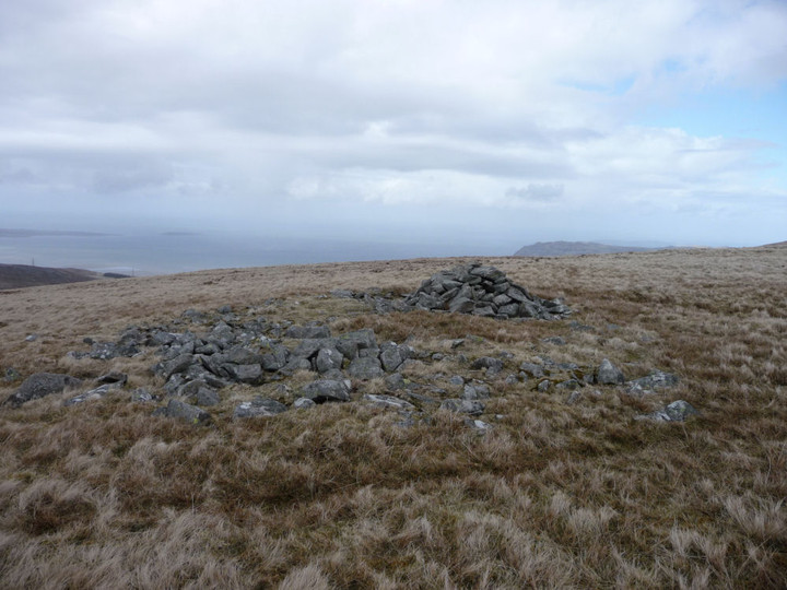
Fine little cairn with central cist.

Looking NE with Llefn and Gyrn looming above.


Somewhat distant Moel Eilio seen from Bwlch ym Mhwll-le near Moel Faban in the Carneddau. The much-trashed cairn can just be seen as a pimple on top of the mountain.
It’s a steep climb for tired legs up onto the Moel Faban summit ridge, and the horizontal rain chooses this point to restart its assault. Gladman may wish to look away now, but we take shelter in the hollowed-out centre of the northern of the summit’s sizeable cairns. This one reminds me very much of some of the big examples on the western tops of Y Mynydd Ddu in South Wales.
The rain relents a little, to the north the blue skies pretending it’s still a lovely day. We emerge from hiding and carry on along the ridge. All the cairns here are magnificent, and the views from this relatively modest hill are superb. A fine example of how a look at the map is no substitute at all for a visit. And a great finish to the day with plenty left to come back for another time.

The knackered northern cairn, looking across to Ynys Mon.

The less-knackered central cairn, looking north. The shoulder of Moel Wnion fills the right of the picture.

The southern cairn, looking SE towards Yr Elen and Carnedd Dafydd.

The modern marker cairn at the southern end of the summit ridge boasts terrific views of the Ogwen Valley. I can’t find anything to indicate that it is built from anything older, but there’s so much going on up here that I wouldn’t discount it either.
It’s with much weariness that we make our final descent past Pen-y-Gaer (Bethesda), crawling along the same prosaically named back streets that the car took us along so many hours earlier. What a day it’s been. Time has emptied the settlements of the high valleys, denuded the cairns on the peaks, leaving this quarter of the Carneddau a remote, wild landscape. But to the mountains themselves, Man’s presence has been but an eye-blink. The shattered tops and tumbling waters have seen Time immeasurable, impossible spans for the human brain to comprehend. But we are compelled to try, and so it is that we will be compelled to come back.
Fantastic, " the Pass of No Bridge", "sideways stinging face rain", "weirdly splayed dead sheep", "Big rocks", and that bloomin' wind. I think you pretty much nailed it.
It really doesn't get much better than this, not half.
Cheers, glad you enjoyed it. Can't wait to get back up there though.
More exposure, in more ways than one. Good work you two.
Thanks Mr G, it was a lot of fun, if that's work I'd gladly sign up full time!