|
Visited 7th May 2014
It’s a gorgeous day as we head down to South Ronaldsay on my obsessive quest to visit every little mark on the O.S. map that could possibly be an ancient site. Today will be a treat though, as I’m on the hunt for a standing stone, which should hopefully be more visible than some of the indeterminate lumps and bumps I encounter when looking for some of the more obscure sites I’ve yet to see.
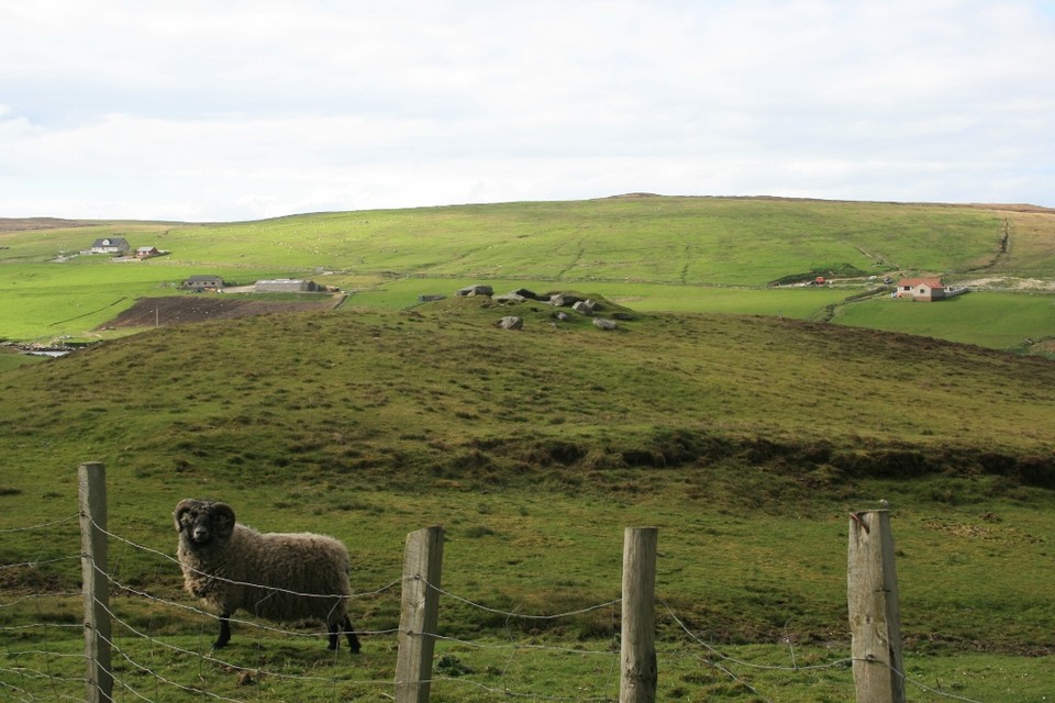
Traveling south down the main A961 on South Ronaldsay the red phone box, just after the turn to Sandwick, makes a good indicator of the left turn you need to take into the lane which leads to the stone. The lane narrows and becomes more potholed, looking as if it will peter out at any minute, but putting our faith in the O.S. map and persevering with the bumpy conditions brings us to a handy parking spot at the end of the road. You can access a path down to the beach from here, but our destination lies in the opposite direction, as we head towards the stone that we’d spotted on our approach, near the crest of the hill behind us.
Clambering over a field gate just up the lane, back the way we’d come, gave us access into the field adjacent to that which held the stone, clearly visible and beckoning us on, and an open entranceway took us into its field.
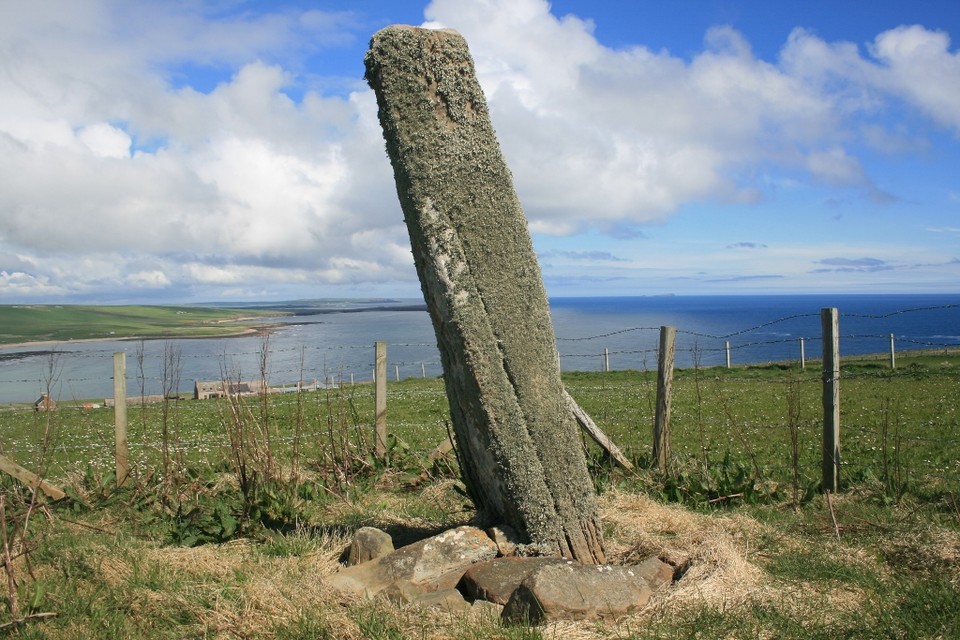
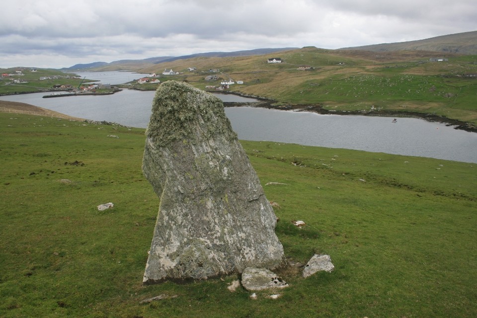
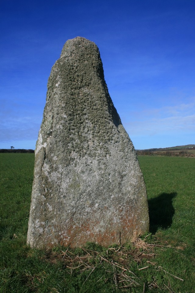
The stone at Stews is around 6’ in height, fenced in behind a low and rickety barbed wire enclosure, the reddish stone is almost entirely swathed in Orkney’s ubiquitous lichens. I step over the barbed wire fence so as to get up close and personal with the stone, and settled myself down, relatively comfortably perched amongst the chocking stones visible around the base.
The siting of the stone is divine, fine views open out to sea, looking out across Newark Bay. The mossy stone is cushioned against my back, the sun warm on my face, the honking of Greylag Geese strutting around the moorland at the top of the hill the only sounds to be heard, and I could almost doze off sat here in the little barbed wire pen.
I take my typical variety of photo’s from every conceivable angle, whilst Ellen photographs me looking like an exhibit in a human zoo, (the rare lesser spotted megalith enthusiast in their natural habitat!). This is another of those stones that takes on a different appearance from each angle, looking like a stout pillar from the side on, the other faces being triangular and fin-like. It’s a lovely spot here, easy to get to and a stone that’s well worth a visit. On a day like today we take advantage afterwards and head down to the beach, a lovely stretch of sand that we’ve got completely to ourselves, well if you don’t count the Oystercatchers!
|
 
|
Visited 11th May 2014
Winding our way around the scenic west side of Mainland after a visit to Staneydale Temple, and the landscape is like Scandinavia in miniature, each turn of the road allowing a vista over another fjord like sheltered inlet, and occasional coloured wooden houses clustered together around the coast. I’m navigating whilst Ellen drives, and I suggest we head towards Aith, a village our information leaflet optimistically describes as ‘a large township in a scenic setting’. Whilst Ellen has visions of a little coastal town replete with coffee shops, my ulterior motive is that I’ve spotted those magical words ‘chambered cairn’ on the O.S. map right next to the road we will follow out of the village.
While I wouldn’t exactly describe Aith as large in any shape or form, it’s certainly in a picturesque setting, but sadly lacking anywhere to get a coffee, so onwards we go around the coast of Aith Voe, before the promised cairn appears in a field to our left.
There is a handily placed passing place right by the fieldgate, so we pull in. Ellen stays in the car, worried me might block the road should we be caught up in the Shetland rush hour, but given that the volume of traffic along this road seems to be at best one car per hour, I think we’ll be pretty safe.
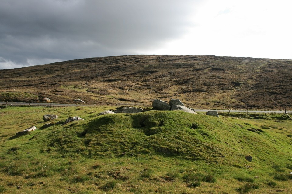
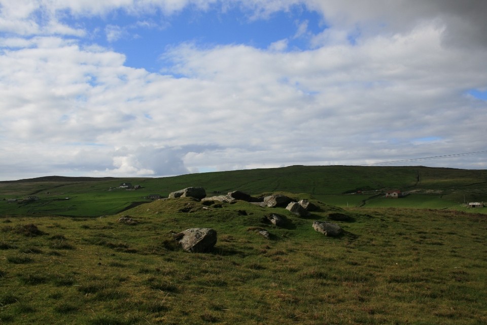
I open the gate and am approached by two curious rams, who look at me expectantly as if I’ve brought them some food, and follow me at a distance to the nearby cairn.
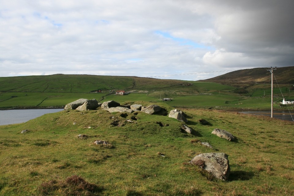
It’s a small structure, a ‘peerie’ mound as they’d say in these parts, but despite being dug into, denuded and raddled with rabbit holes, enough of the form remains to give a good impression. Large stones outline the central chamber, and again the siting of the monument takes in a lovely vista overlooking a sheltered bay, in this case East Burra Firth itself.
I really like it here, I know I always seem to wax enthusiastic about each new site I find, but it does have an indefinable atmosphere, a certain pull here which gives the place a presence beyond the size of its actual physical remains. Maybe it’s the setting, or perhaps the joy of finding somewhere new but I loved it. I do my usual thing of taking photos from every conceivable angle and sit in the dip of the mound to write my fieldnotes, sheltered from the wind. I don’t want to leave Ellen on her own in the car for too long, and she’s still reticent about entering the field, more so now due to the rams still giving me the eyeball from near the gate, so before long I bid my goodbyes to the cairn, farewell East Burrafirth, it was lovely to make your acquaintance.
|
   
|
Visited 9th May 2014
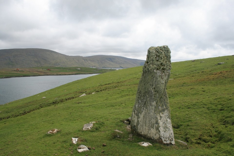
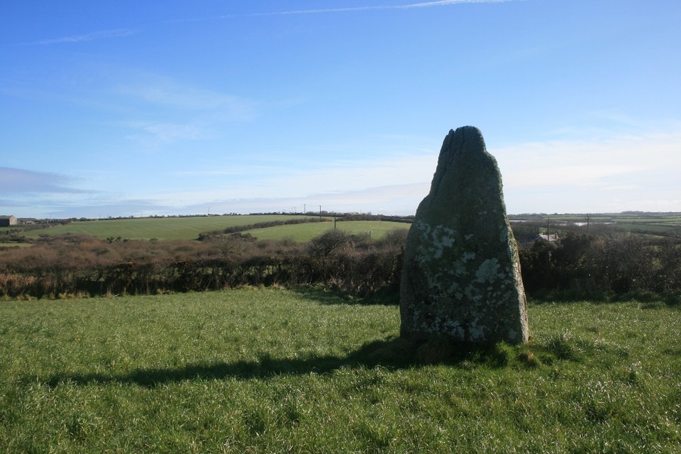
When picking a megalith to visit just on the basis of that intriguing gothic script saying ‘standing stone’ on the O.S. map you never know quite what you are going to get. But in the case of Mid Field what you get is a fine stone in a beautiful setting looking out over South Voe.
On the drive down West Burra we had a close encounter with an otter, which ran out across the road right in front of the car (fortunately we managed to stop in time!). It really is picturesque here.
As Carl mentions in his fieldnote the stone is easy to spot from the minor road south of Bridge End. We pulled up in a passing place almost adjacent to the stone, and at first I head down to the end of the fence to access the field via a gate. On getting there though I notice an assemblage of sheep pen fencing forming an enclosure next to the gate, with visions of the whole lot collapsing were I to clamber over it, I think again. Never one to be deterred though when it comes to visiting stones I turn to plan B, and looking as if I’m about to emulate a John Cleesesque silly walk, manage to step over the relatively low fence.
There are no sheep in the field today though, only three rather friendly Shetland ponies. The stone is fin shaped and angled towards the loch below, with the surrounding hills providing an impressive backdrop. With this stone it’s all about the location, the relatively modest proportions of the stone belying the overall impact it has when you are here.
Burra is only around ten miles from Lerwick, and easily accessible, and I can only echo Carl’s words and say come and pay it a visit!
|
 
|
 
|
Visited 10th May 2014
Heading up Mainland for Northmavine the clouds were gathering in already overcast skies, but you don’t come to Shetland for the weather, rather for its wild landscapes, wildlife and of course a rather generous selection of standing stones.
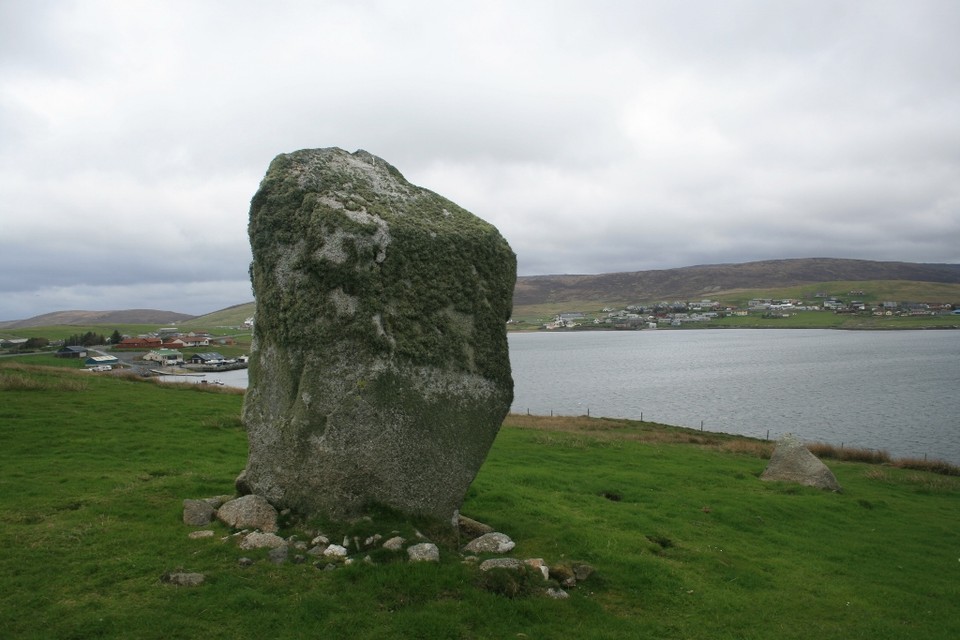
The Busta stone is one such impressive monolith, and easy to spot from the A970 just past Brae.
Turning off the main road we parked in a small layby next to a cattle grid, the other side of which was the gate allowing access to the field, empty today apart from the stone itself.
The wind was whipping at us as we approached, the bulk of the stone looming high above us, and providing a seemingly warming embrace, as we huddled in its lea out of the wind. The stone is huge, it’s difficult to get an idea of its scale until you stand next to it, the ever present shrubby lichen masking its top half.
This is a great location for a standing stone, looking out over the waters of Busta Voe, and one face of the stone does indeed seem to take on the aspect of a head rising from the ground, the lichen like a blindfold over its eyes. Canmore mentions a possible second stone, now fallen, to the east, and whilst I did notice a smaller stone nearby protruding from the ground, I didn’t really think to check it out, thinking it probably natural.
The huge granite lump of the stone seems somehow smaller as we walk away, swallowed in the wild landscapes of Shetland, but it’s certainly one of the more accessible menhirs here, and a must visit in these far flung northern parts.
Later on returning from the hinterlands of Northmavine we pass the stone again as we follow in Carl’s footsteps and call in for some chips at Frankie’s, and have no hesitation in recommending both the chippie and the stone!
|
Visited 6th May 2014
Gorgeous day at Brodgar. I walked over to the huge mound of Salt Knowe, still currently fenced off, to see how the anti-rabbit proofing was getting on. It didn't take long before I had my answer, as several families of bunnies could be seen happily enjoying the sunshine on the slopes of the mound.
The green matting used to cover the Knowe currently gives it a threadbare appearance, and several holes leading to burrows were clearly visible gnawed through the mesh, so it looks like a rethink may be in order!
|

|
   
|
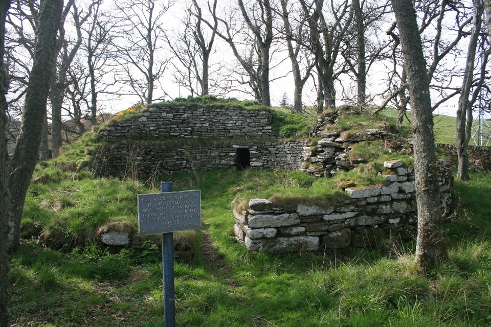
Visited 7th May 2014
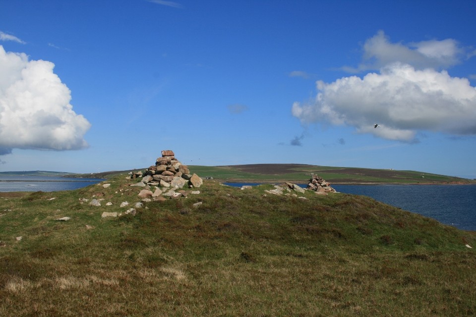
Hunda is a small uninhabited island attached to the larger isle of Burray by a causeway. As well as being a great place to see birds, seals and apparently one of the best spots on Orkney for otter spotting, it also sports the remains of a hulking great cairn.
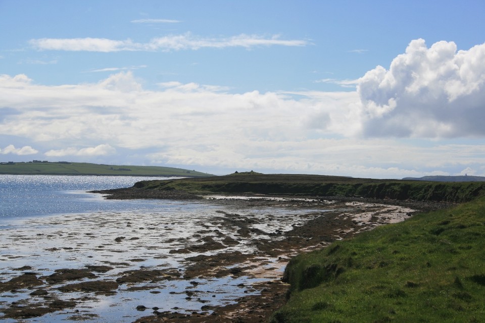
The weather today is as good a day as you could wish for, lovely blue skies, some genuine warmth to the sun, and the warm zephyr like breeze is most un-Orcadian. So after a nice lunch at the café of the Burray Rock & Fossil museum a walk was in order, and even better one that takes in a visit to an ancient site. A short drive south past the waters of Echna loch, brings you to a right turn signposted to Littlequoy, and following the lane to its end, near the farm of the same name, gave us a bit of verge on which we could park the car.
The sea sparkled blue below us, and we could see Hunda stretched out across the narrow sound, with the causeway of Hunda reef cutting through the water. A walk down the farm track allows you to access the foreshore without having to walk across the farmyard, and we walked along the pebbly beach to the causeway accompanied by the echoing cries of Oystercatchers.
The causeway is a permanent one, not cut off by tides, so no danger of stranding on a barren island today, although care must be taken on its slightly uneven surface, and I certainly wouldn’t attempt to cross in bad weather, as I’m sure it could be fairly easily overtopped by waves, so as ever on any visit a certain amount of caution is required.
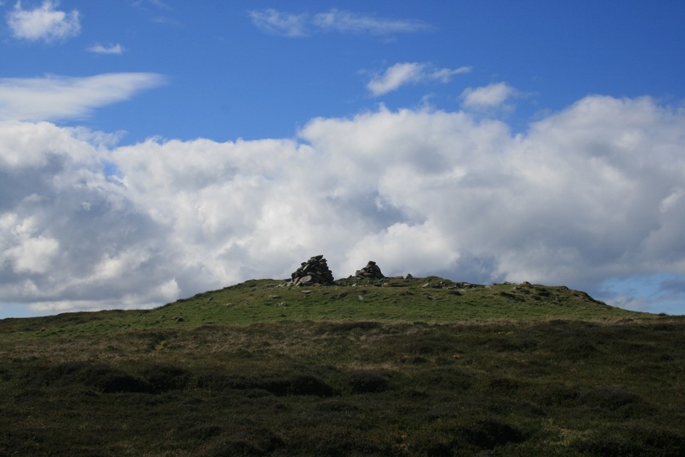
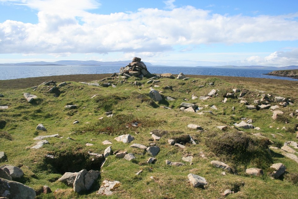
The cairn at Cairnhead is clearly visible on the southern tip of the island as we cross the causeway, two modern cairns at either end of it sticking up like small ears. A clearly trodden path leads all around the coast of Hunda, and we follow it across a small stretch of heathland up to the cairn.
Up close its size is impressive, the top is now heavily denuded of stones, looking as if someone’s taken a giant scoop out of it, but it does uncover what might be the remains of a cist. The two modern cairns at either end delineate the width of the mound, and make it an unmistakable landmark. We sit at the cairn and relax for a while enjoying the lovely views out over Scapa Flow. The blues of sky and sea are almost surreal, and the bright pinprick of light from the Flotta flare at the oil terminal to the west marks the horizon. Due south the cairn of The Wart, atop Hoxa Hill on South Ronaldsay is directly in line, and I wonder if there is any significance in the alignment?
Canmore reckons The Cairnhead may have been a broch, but I just don’t see it myself, I can’t find any features that are vaguely ‘brochlike’, yet a cist chamber is visible? Hmm, well they’re the experts I suppose.
Whatever it may have been (and sometimes the uncertainty just adds to the mystery of the place) this is a lovely spot, made all the better by the solitude. Ellen and I are currently the only human beings on this island, and relaxing here, contemplating, and just watching and listening to the myriad of birds that make this place their home, pervaded by the atmosphere of this ancient place, the magic of Orkney has us captivated once again.
|
Visited 3rd May 2014
There’s a wildness to the far north of Scotland, a bleak beauty and atmosphere quite unlike anywhere else, and surprisingly more ancient remains than you might realise. On our regular trips back up to Orkney we’ve been making an effort to try and visit at least one new place each time. Today the lucky site was Dunbeath broch, a nice and easily accessible site to break up our ten hour drive.
The A9 normally thunders past the village of Dunbeath, but if you take the time to turn off and park at the Dunbeath heritage centre, an old mill signposted from the turn and a mere minute from the A9, you’ll be right next to a nice footpath which leads to the broch, as well as, according to the nearby information board, a few other enticing megalithic sites.
The walk along the Strath of Dunbeath is beautiful, the babbling of the river a gentle accompaniment to your stroll, with little sound other than that of birds to be heard. The trees flanking the path are shrouded with a pale green moss, which hangs from the branches in wisps, and adds to the ethereal atmosphere.
Soon we are confronted by a slightly wonky looking Indiana Jones style wooden suspension bridge over the river, which despite my remonstrance’s to Ellen about its structural integrity, wobbles and creaks in such as precarious manner as to cause her some consternation. I scoot across it, and with some encouragement Ellen joins me on the other side, where the path forks. Directly ahead the path heads up a steep incline, at the top of which a dry stone wall is visible enclosing a stand of trees, and within which I know the broch can be found.
The broch is not the biggest or best preserved I’ve ever seen, but any shortcomings it might have are more than made up for by its atmosphere. Inside the enclosure of the dry stone walls a circle of moss covered trees protectively surround the remains of the broch. The open tower interior faces you, with the highest remaining parts of the walls at the back, and a small entranceway to a chamber built into the thickness of the wall encouraging you in. Although a low stoop is required to enter the chamber once inside it’s possible to stand upright, the roof, displaying fine corbelling, must be a good 7’ high.
I’m impressed with Dunbeath. As I walk around the exterior of the ruined broch wild primroses can be seen growing in clumps at the base of the walls, the sheltering trees reach out skeletal, branch like fingers over the tower, and mosses and grass colonising the still firm masonry give a sense of the broch gradually settling into the landscape and becoming another part of nature. I feel like I’ve stumbled upon something from a landscape out of Game of Thrones, but of course this is better because it’s real, and I’m here, enjoying just another part of Caithness’ rich historic remains.
We’re conscious of the time, having a ferry to catch, but it’s been much better spending time here rather than hanging around in Scrabster waiting for the boat (if you’ve ever been to Scrabster you’ll appreciate why!) and it’s a place that definitely warrants a return visit, especially since a visit to the broch can be combined with a lovely tree lined walk which continues along the river and on to some chambered cairns and a standing stone further down the valley.
|

|
  
|
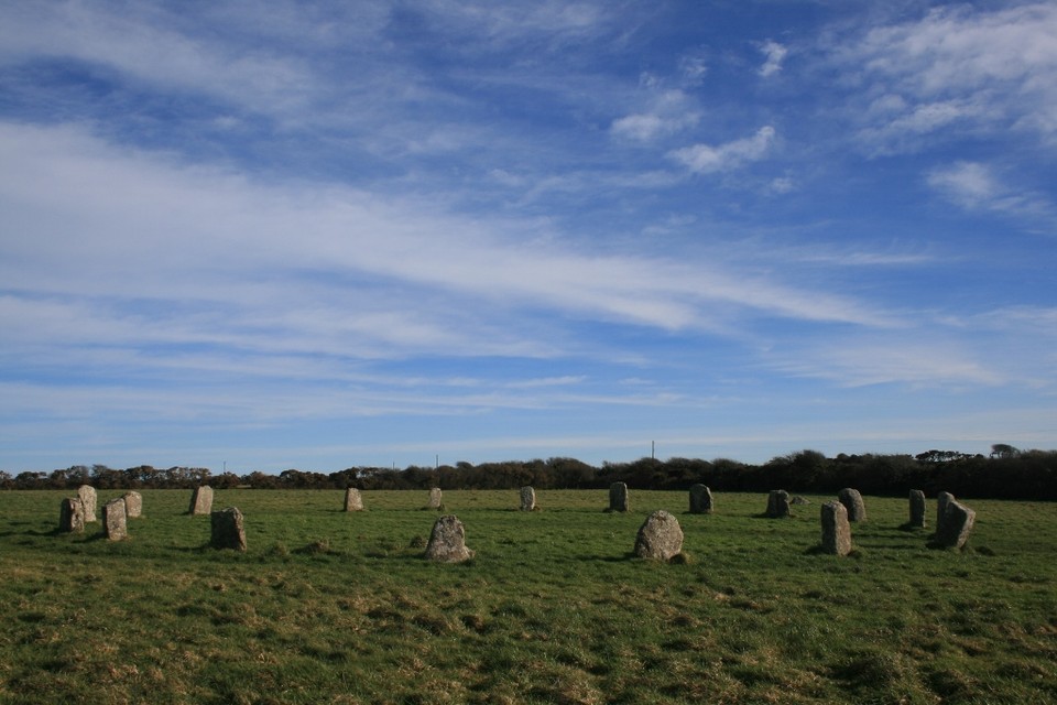
Visited 9th March 2014
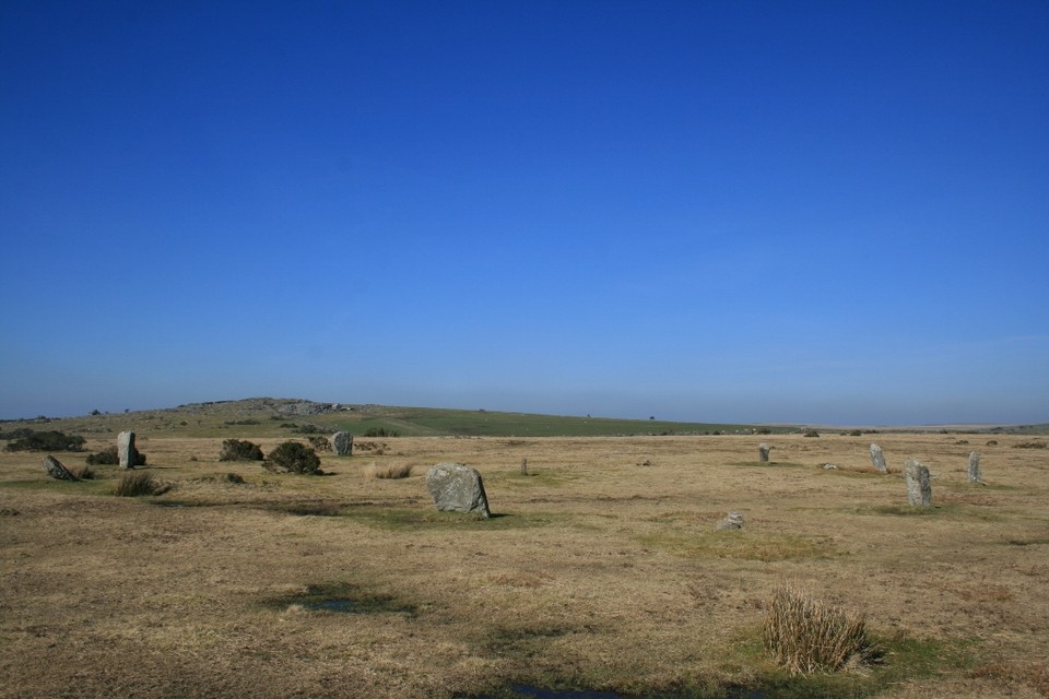
Another session of Google Earth scrying along with Ocifants excellent directions, led me to believe this site would be easily to visit on the way home from our holiday in Cornwall. So with the sun blazing down from a clear sky, and with the car packed and ready for home, we started our journey north with at least the promise of a stone circle on the way to keep our spirits up.
Heading north we took a left turn off the A30 signposted ‘St Breward 4’, which I recognised from my earlier Google reconnaissance, and heading across the small moorland road, we first saw what appeared to be several small standing stones dotted about, along with a variety of other interesting looking lumps and bumps.
Soon we spotted the circle itself off to our right, the telegraph pole right next to it providing an unmissable landmark. I’d intended to turn right at the first crossroads up the farm track towards the circle and park near Hawkstor farm, but on arrival the track looked in a poor state, a huge gouge out of the surface leaving a nasty dip to be negotiated in order to pass. Fearing for the car’s suspension, and with still another 250 miles to drive before getting home, I decided not to risk it and instead turned left towards Treswigga, and taking the example of another couple of cars, pulled up on the spacious verge.
No maps were needed today, the visibility perfect, the stones of the circle beckoning to us across the moor. The pull of a previously unvisited site causes me to hurry past what looks like a small stone row, but I vow to investigate on the way back, and soon I’m here in the centre of the stones, looking out over the empty moorland and soaking up the atmosphere. As Postie says, there is a feeling of ‘bigness’ here far out of scale with the actual size of the stones or circle, probably the wide skies and open moorland give it a sense of a larger landscape.
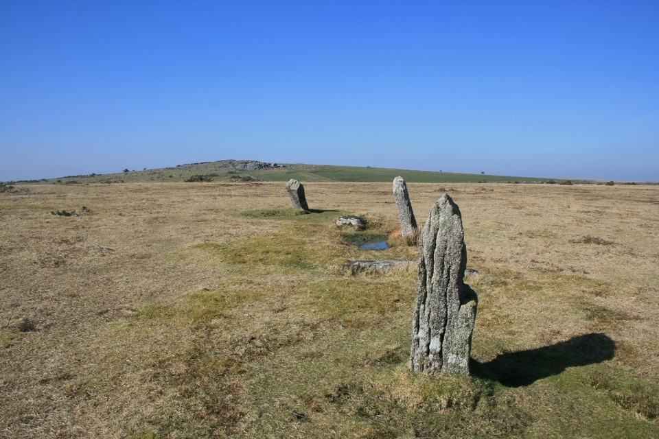
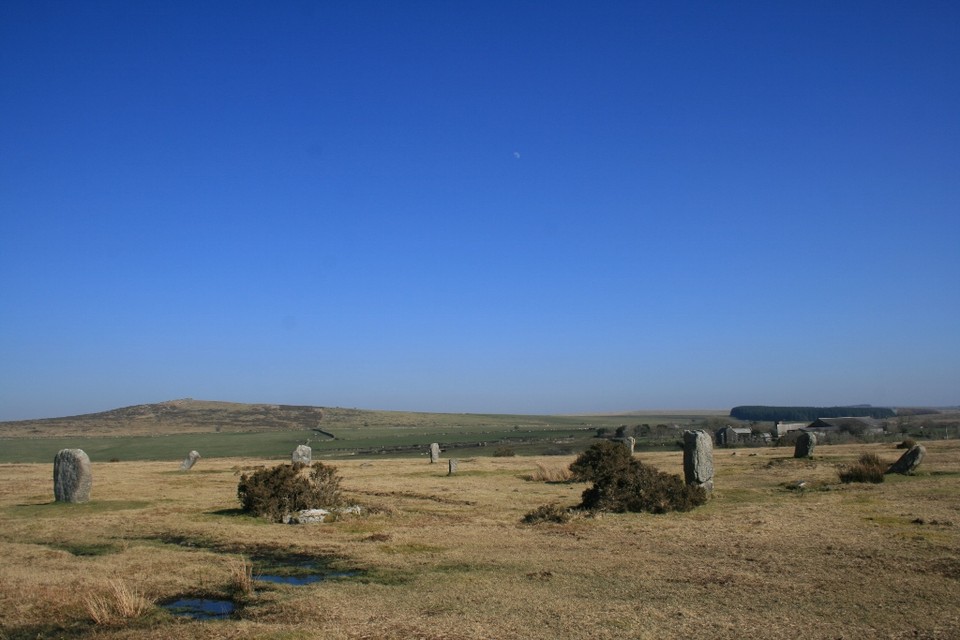
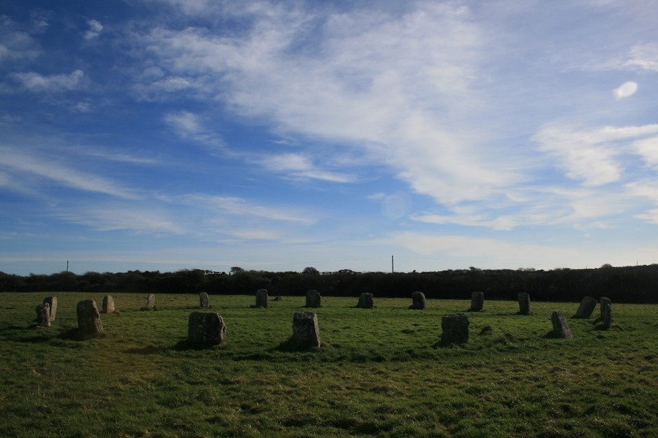
The circle of eleven remaining stones (or is it twelve, we seemed to get different results each time we counted!) looks as if it’s had a battering over the ages, but I’m pleased to see that currently there are no signs of erosion by livestock around the stones themselves. A small central stone, and two further outliers which line up to it intrigue, but on closer investigation it’s clear that they don’t fit with the rest of the circle, the carvings of ‘M’ and ‘C’ on them pretty much confirming their use as boundary stones across the moor. Normally this sort of interference with a site would annoy me, particularly when it’s a result of the imposition of artificial fences or boundaries that impact on things (I’ll stop there before I start on a rant about the ‘ownership’ of land!), but here it just sort of fits in. In fact there is an absolute air of relaxation about the whole visit. Maybe it’s the unseasonable warmth of the sun, maybe it’s just the vibe of the place but I’m feeling particularly laid back, and just suffused with an aura of happiness and wellbeing. Ellen feels it too, so it’s not just me coming over all hippyish, and we sit in the circle with a flask of coffee and some very lovely chocolate muffins from the bakers in St. Just, and just chill out. On a day like this people will be flocking to the Cornish beaches, but nice as it is to be beside the seaside, I’d rather be here on a lonely moor, away from the crowds at this lovely ancient place. A couple of dog walkers are visible in the distance, but no-one else seems to pay the circle any mind, or intrude on our blissful solitude.
While Ellen goes off to take photographs I recline on a recumbent stone and feel so completely relaxed I’m almost drifting off to sleep, the gentle susurrations of the traffic from the nearby A30 and the tweeting of birds providing a soothing soundtrack, and from my prone position looking around it’s almost as if the circle sits within a natural amphitheatre of hills, with the rocky outcrops of Carbilly and Hawk’s Tor looming large on the horizon, and the moon visible in the sky hanging over the circle only enhancing the numinous atmosphere.
I’d love to have visited the nearby Stipple stones while we were here, but we’d already spent nearly two hours at the circle, and with a pint at the Jamaica Inn calling, and a further four hours of driving ahead of us before reaching home, we had to drag ourselves away.
This place has been a revelation though, probably the perfect combination of fine weather, the endpoint of a great holiday and the giddy excitement of going to a site for the first time, means it’s exceeded all expectations. Knowing now how easy it is to get to, I can see this being a regular stop off when we come down to Cornwall again.
|
  
|
Visited 8th March 2014
This was another site on my must see list for this trip down to Cornwall. With some judicious Google Earth scrying beforehand, in conjunction with a trusty O.S map, I’d identified the parking spot on the bend mentioned in Carl’s notes.
We approached down a narrow lane off the A30, a signpost warning that the track was unsuitable for HGV’s, and even in our little car it was tight going. Ellen drove as I navigated, somewhat fretful in case she met something coming the other way, as there were few passing places, and reversing on the narrow twisty roads would have taken some doing.
Following the signs towards Carn Euny we reached an even narrower track, this one with a no through road sign at the start of it. Ellen was reticent about taking it, but I encouraged her to take a drive of faith and so we carried on. Within minutes there is a thick band of grass growing up the centre of the road, but we’d come this far so there’s no turning back now! It’s not long though before I recognise the pull-in next to the public footpath sign I’d seen on Google Earth.
Parking up here Ellen decided to wait in the car, worried in case we ended up blocking the way for some huge agricultural machinery, and also being a bit more wary of trespassing than my blasé attitude towards it. I happily hopped over the gate however, and walking up the edge of the currently empty meadow, again followed Carl’s directions into the neighbouring field.
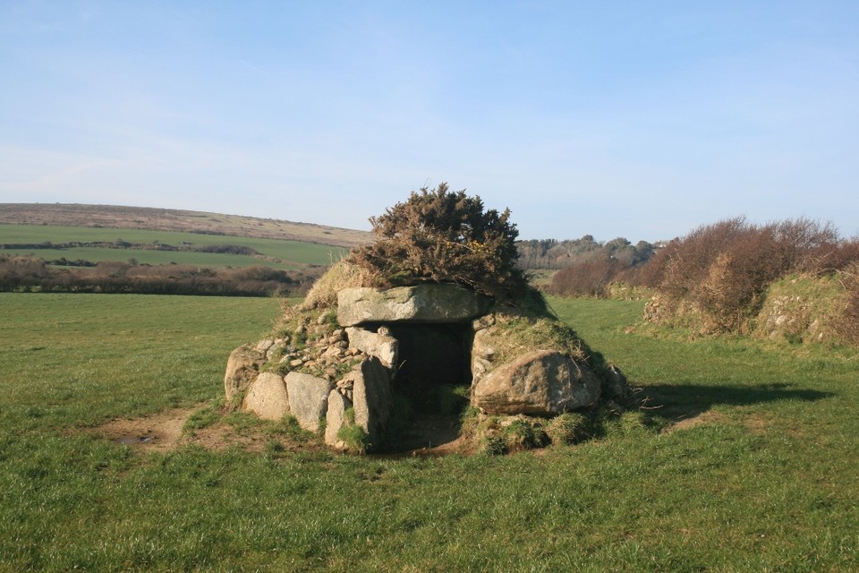
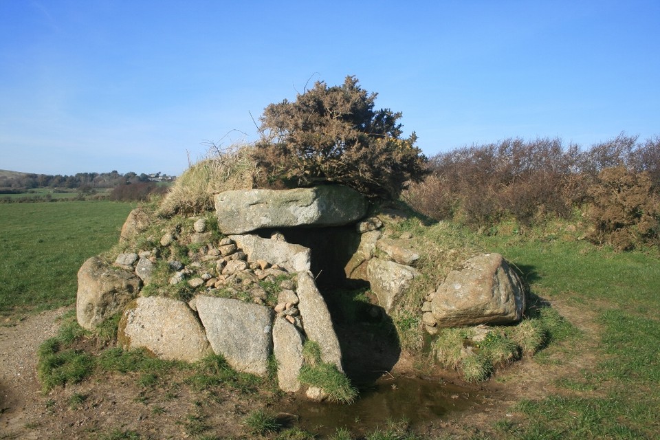
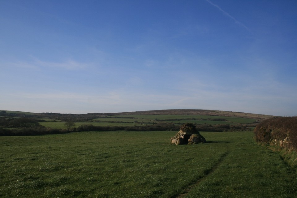
As I entered the field I was taken aback, the burial mound, so perfectly small and round sitting there incongruously in the field, just looked so unreal. Getting up close I could see just how different this chamber seemed from other barrows I’d visited, looking more like a roundhouse than a tomb (perhaps that’s the idea?).
Either way it’s lovely, probably the first chambered tomb I’d describe as cute. The gorsey toupee just adds to its character, and the vegetation growing around it gives the place an organic quality. As I bend down to look into the entrance it’s almost as if the stones of the entranceway are reaching around to give me a hug. Squeezing into the chamber, no slugs are in evidence today, but creeping tendrils of bramble are starting worm their way in, grabbing at my coat, and I really wish I had a pair of secateurs with me just to keep the chamber clear.
As I lean against the side of the mound to write my notes everything seems a bit illusory here, the sky is perfectly blue, the grass low cropped and gently rippling in the breeze, the lonely cawing of crows overhead, and not a sight or sound of the modern world in evidence. It’s like some bucolic idyll, and it feels as if nothing has changed since Borlase was here, if ever a site had a palpable vibe, it’s this one.
Utterly enchanted I forget the time, and feeling a bit mean about abandoning Ellen, I drag myself away, only to find on my return she’d dozed off in the car, so I could have stayed a bit longer I suppose! Anyway I will be back!
With all the abundance of megalithic wonderment crammed into this small part of West Penwith it’s interesting that this little burial chamber seems to have affected me most of all the places I’ve been so far this week, I can’t recommend a visit to this hidden gem highly enough.
|
Visited 8th March 2014
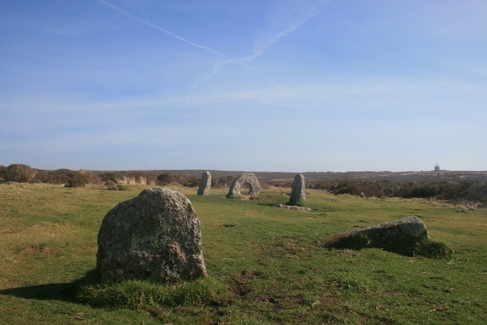
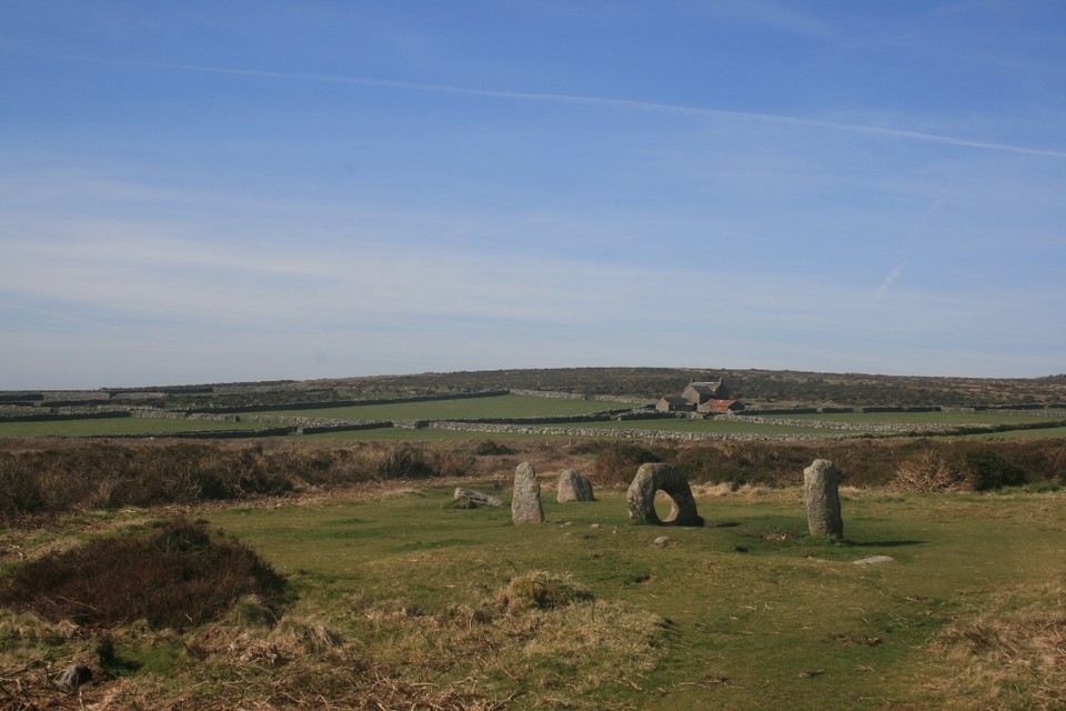
My quest this week was to visit the four West Penwithian stone circles, and the Boskednan Maidens were the last elusive stones to find. Our intention had been to park at the Men-an-Tol lay-by and walk from there to the circle. On arrival though our plans were foiled by due to a plethora of horse-boxes and 4x4’s disgorging the local hunt, and blocking up the pull in and nearby verges, and clogging the road with all the arrogance and inconsideration that only a bunch of red coated buffoons can exhibit.
Continuing up the lane we spot a place to pull in just on the left, opposite a track to a house called Dakota. A quick check of the O.S. map shows we can reach the stones from here, and then head via Ding Dong back down to Men-an-Tol, the engine house of the ruined mine providing a useful landmark with which to orient ourselves. We set off along the path onto the moors, and before long I’m delighted to spot the stones on the skyline.
Tramping across the moorland it’s a great walk, but very muddy, wellingtons again proving their worth. After walking for about twenty minutes, and fixedly gazing at either the stones on the horizon, or our feet lest we tread in a muddy bog, I look back and notice Men Scryfa some way behind us. I’m annoyed we missed it, but would rather spend more time at the circle than go back to visit it now, so as always, there’ll be another time to visit I’m sure, and it’s always a good excuse to return (as if I need one!).
We steadily climb up the ridge of the moorland, the circle temporarily hidden from view, before coming upon some stones, which I initially take for the circle, and am a bit taken aback, as it seems a lot smaller than I was expecting. It’s only when Ellen points out some more stones ahead, that I check the map and realise we are at Boskednan cairn, a nice bonus to stumble on as I didn’t even realise this place was here!
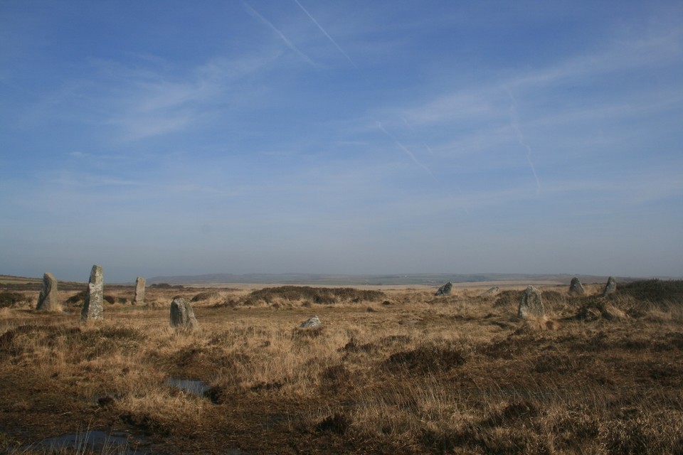
It’s been a walk of just under two miles, but the circle is soon reached, and what a lovely atmospheric place it is. The eleven stones (the nine maidens in this case coming from the magical symbolism of the number, rather than the extant number of stones), lean attractively in that romantic ruin type of way. The dun winter shades of the moor make it look as if the stones are sprouting organically from the ground. It’s still windy, but also seems surprisingly sheltered, and the circle has a warmth about it, a welcoming sheltering place atop the bleak moors.
The contrast between the Boskednan maidens and the Merry Maidens couldn’t be greater, for all the manicured perfection of the latter, here is a wild elemental place, raw, lonely and magnificent, and all the preferable for it. A truly wonderful circle.
|

|
Visited 8th March 2014
I’d been itching to get back here all week, seeing as it was just a five minute walk away from where we were staying, however every morning I got up to be greeted by either grey rain swept skies, or cold dank sea mists. Today however I was woken by bright sunshine peeking its way through the curtains. So enticed by the thought of a barrow before breakfast, I was up and out by 8am.
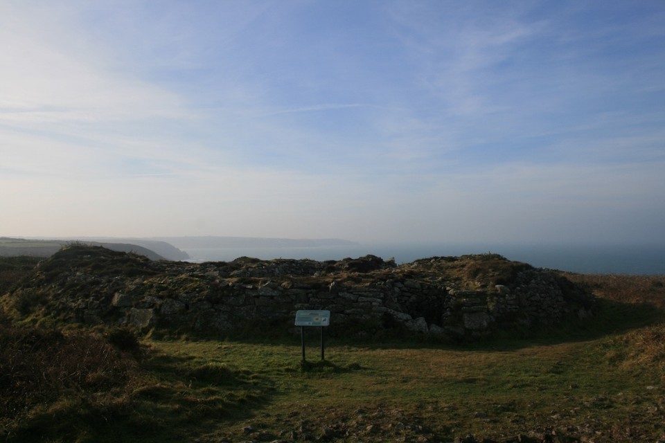
Just a short walk along the top of the headland above Priest’s Cove and I arrived at Carn Gluze, and now knowing why the sea mist had vanished, blown away by a bitter wind of such incessant force it made me homesick for Orkney!
The barrow itself is big. Standing in the shadow of an old mine chimney which looms nearby, it could at first glance be mistaken for the remains of one of the old industrial buildings, or the remains of a spoil heap, which is not helped by the 19th century ‘reconstructions’ of William Borlase, which only seek to confuse the layout of the site. Climbing onto the outer stone ‘collar’, I’m almost blown off by the wind, but clambering down into the space between the dry stone walls allows me surcease from the icy gusts, and the ability to inspect the cists a bit better and write my fieldnotes.
It’s certainly an impressive place, and amazing views are to be had out to sea, looking down to the Land’s End peninsular, but I find it difficult to get a handle on this place. It is very different in layout to most barrows and chambered tombs, and the radical alterations undertaken by Borlase in 1878 obfuscate the original layout to such an extent the monument as a whole loses something for me. I’d love to see a more sympathetic modern archaeological restoration undertaken to more properly bring out the wonder of this place.
My hands are freezing by now, even in the shelter of the barrow, and I’m too cold to stay much longer, so clambering out I bid the place farewell. I’m sure I’ll be back, I’ll need at least few more visits to try and work out this place!
|

|
 
|
Visited 8th March 2014
On previous visits we’d just parked up in the lay-by and walked down the track to the stones, but today Men-an-Tol came at the end of our circular walk over the moors.
We approached down the path from Ding Dong mine, and all was well until we reached the dip at the bottom of the hill where all the accumulated rainwater runoff from the moors had collected into a swampy morass. Ellen was a bit perturbed about crossing the quagmire but with the famous last words of ‘Don’t worry I’m sure it’s not that deep’ I strode forward and plunged knee deep into sucking mud. Fortunately Ellen was able to extricate me from the bog whilst miraculously managing not to loose my wellingtons, and we gingerly picked our way through some tussocky areas just visible above the water.
After this it was all plain sailing on the rest of the walk. The stones are so small though they’re not really that noticeable from this direction until you get right up close to them, then seeming to magically appear from the moorland in front of you. We’ve got the place to ourselves, a rare occurrence, and it’s nice to rest in the sunshine by the diminutive stones. I’d forgotten how small they were, and despite lacking the grandeur of some of Penwith’s other sites, and if you wanted to be unkind, perhaps looking a bit like a garden feature (although this is exactly the sort of thing I’d give anything to have in my garden!), there is an indescribable something to this place, that grants it a magic all of its own.
I’m pleased to see no signs of cattle damage or erosion as I walk around the stones, although today I’m too tired and muddy to squeeze myself through the holed stone. Instead I bend down and look through the aperture, loving the perfectly smooth roundness of the holed stone as I run my hand around it. I know it was once supposed to be a stone circle, but it just seems to me so unlike any other monument of that type, I do wonder. Making the hole in the stone would have needed tremendous effort, and if the monument was once a circle with the holed stone as a just a perimeter stone set obliquely to the rest, why go to all that effort? I would have expected it to be more of a feature, perhaps a portal entrance or setting within the circle, or perhaps it was the case that the hole was made later in an orthostat, perhaps after the circle had fallen into disuse. It all just adds to the enigmatic mystery of this lovely place.
So after a good long ponder, we finally set off down the track which takes us back to the lane and the end of our walk, tired, happy, and with the prospect of a nice lunch in the Kings Arms at St Just ahead of us, exactly what a day out megalithing should be!
|

|
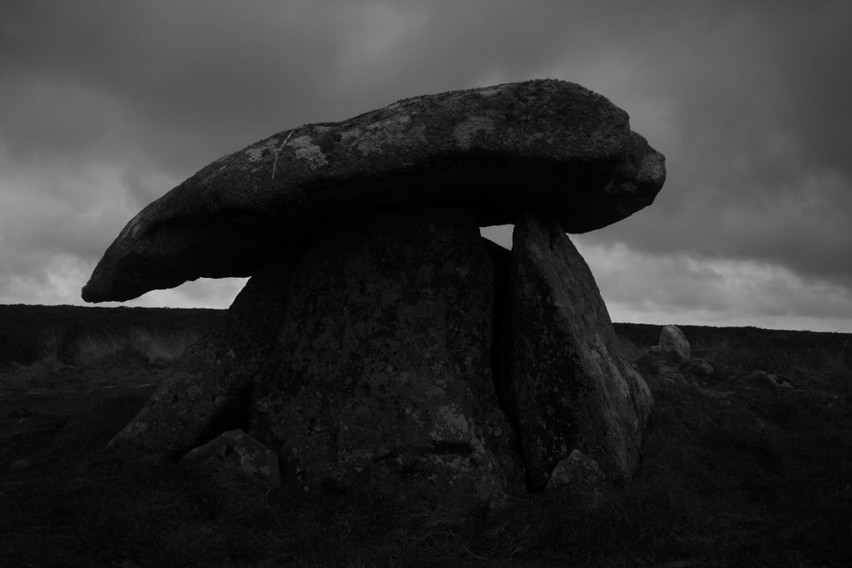
Visited 5th March 2014
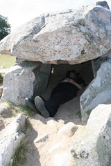
This place has been high on my list of must see sites for ages, and I must say it didn’t disappoint. Parking up at the wonderfully named Woom Grumpus common on the B3318, the quoit is visible on the horizon from the parking spot. Wellingtons were an absolute necessity as to describe the path as ‘boggy’ would constitute a gross understatement!
Huge puddles of indeterminate depth straddled the path, but properly equipped for a change we soldier on, the walk up to the stone being just under a mile, soon though we arrive at this most perfect of dolmens. Wonderful vistas can be had from the site looking out over the sea, but skies are grey and murky today, low cloud clinging on and obscuring the horizon.
I squeeze into the chamber, but it’s a tight fit. Inside though it’s nice and sheltered, and some handy stones inside allow a perch out of the mud for me to write my fieldnotes. It’s wonderful here inside the quoit, I can hear the wind howling away around the stones, and I feel far from the mundane world, almost as if I’m about to be whisked off to the otherworld at any moment.
The four closely placed orthostats support a wonderful sloping capstone, and I can’t help but admire the economy of design, it’s a dolmen at its most streamlined. The entrance seems to be aligned south-easterly, and the granite tor of Carn Kenidjack looms away to the south in line with the quoit, and possibly the alignment continues on south to the circle of Tregeseal.
I can’t think of enough superlatives to describe Chûn Quoit, although one of West Penwith’s most iconic sites the necessity for a walk to reach it probably keeps away the casual visitor so the sense of isolation remains. A truly wonderful place, and I know I’ll be back!
|
 
|
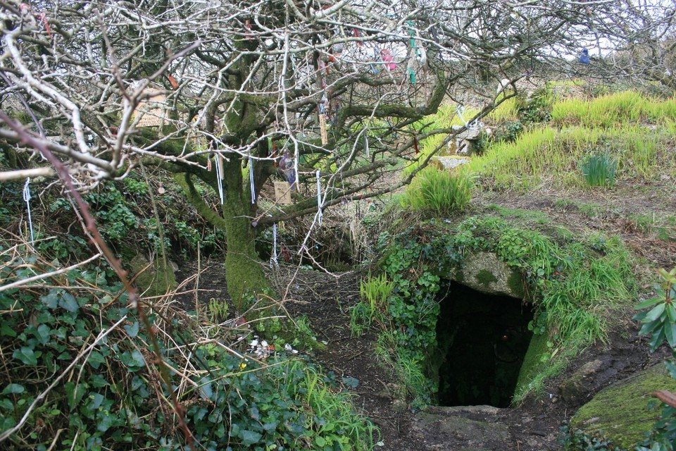
Visited 5th March 2014
Although some of the places we’ve visited on this trip to Cornwall seemed very different to my past recollections of them, Sancreed Well felt so familiar I could have been here yesterday rather than ten years ago. As soon as we drove into Sancreed I remembered the phone box you park up next to, at the side of which is the path to the well.
The path seemed very overgrown though, and I began to wonder how long it might have been since someone last came this way. The answer was obviously very recently as when we arrived at the well the small glow of a freshly lit tealight shone out at us from the gloom of the subterranean well chamber, so someone was here very recently, despite us seeing no sign of anyone around, either on the path or as we drove through the village, spooky.
The well itself is a magical place, a little verdant grotto with an otherworldly feeling as you descend the steps down to the clear cold water, your breath misting in the cave like interior. Green mosses and ferns sprout from the side walls, and no matter the antiquity of this well the tranquil atmosphere it exudes makes it ever a sacred place.
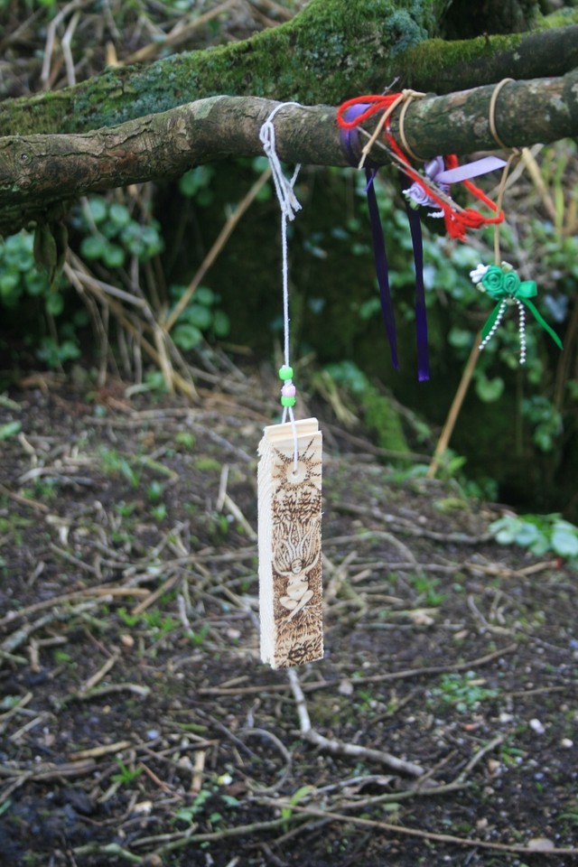
I didn’t notice any phosphorescence in the well chamber, but it probably needs to be darker to see the effect. Although nearby is a modern stone Celtic cross, this still feels a pagan place, the overhanging hawthorn tree covered in offerings. I must say the offerings left here are lovely, several pyrographed pieces of wood hang from the tree, exhibiting an artistry that must have taken some time to complete, crystals, ribbons and windchimes are also in evidence, and there is a refreshing lack of mouldy old ribbons or plastic which sometimes blight these places, it’s evident someone cares for and regularly visits the place, and if I lived down this way I would too.
|
Visited 7th March 2014
The Merry Maidens are almost too perfect. A perfect circle of perfect little stones, in a perfectly mowed field, you almost feel the need to check whether inscribed somewhere on a stone is ‘copyright Disney Co.’ Beautiful but somehow superficially lacking in atmosphere, they are like the supermodel of stone circles, very appealing to look at but somehow a little vacuous underneath.
However on a day like today, with blue skies, and no-one else around (one of the advantages of coming to Cornwall this early in the year) all is forgiven. In fact I’m being a bit harsh as this is a really lovely place, just after visiting the wilder locales of West Penwith’s other circles, it all seems a bit too manicured here.
We wander around the ring though enjoying the sun, now warm on my back, and the gentle cawing of the crows in the next field, and I can see why this place is such a magnet for people, and it’s nice that after 4,000 years it draws folk still.
|
 
|
Visited 7th March 2014
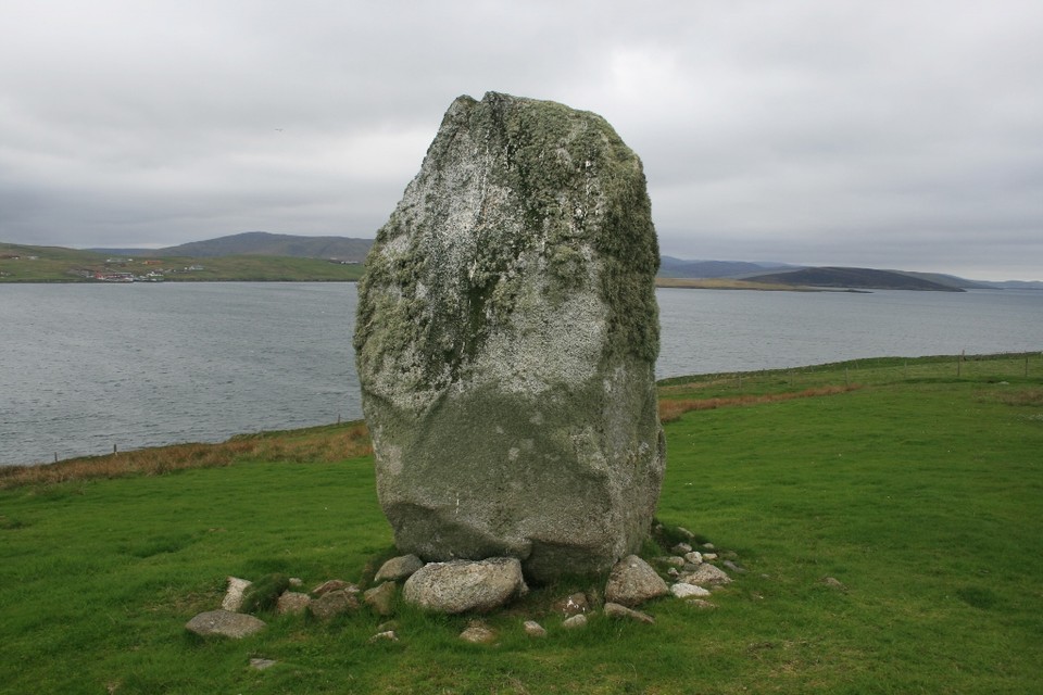
The Blind Fiddler is visible over the top of the hedge which borders the A30, just up the road from the Sisters at Drift. Also handily, almost directly opposite is a layby for convenient parking to visit the stone.
Once over the stile into the field the stone is satisfyingly chunky, and surprisingly tall. The sun glints from flecks of quartz embedded in the menhir, as I approach to give the stone a customary hug. The landscape is too enclosed with hedges to get a proper view so it’s difficult to see any alignments, but the Drift stones seem to be pretty much directly to the east, so I wouldn’t be surprised if there was a link in the past.
The top of the stone is shrouded in lichen, which wraps around its top, like a mossy blindfold, and the stone from one aspect almost resembles a hunched figure stumbling forward, like a petrified Blind Pew (although it has been said I anthropomorphise stones too much!) but standing in this lovely meadow the Fiddler has a lot of character, and deserves more attention than just a cursory glance on a hurried drive.
|
 
|
Megalithic wanderer and modern day pagan.
I've always loved anything historical, particularly megalithic sites (I've many a fond memory of visits to Stonehenge in the mid 1970's as we used to stop there every year on the way to the annual family holiday down in Bournemouth, which I think started it off), and the discovery of a certain book by Mr. Cope set off an obsession in the late 1990's to see as many of these wonderful places as I can.
Enjoys walking in the wildnerness and climbing mountains (currently on the worlds slowest round of Munroe bagging), travel, playing guitar, real ale and malt whisky, historical re-enactment, fencing and wargaming (although not all at the same time!) Also adores small furry critters (particularly cats)
Spends most of the year in the megalithic desert of the Midlands, although fortunate enough to live part of the time in Kirkwall in the megalithic oasis of Orkney, with my lovely (and very patient) wife Ellen, and the cute furball that is our cat Hecate.
Favourite sites would be Callanish and Ring of Brodgar (where I was handfasted) in Scotland, Les Pierres Platts in Brittany, Havangsdosen in Sweden, Glavendrup in Denmark, and Sunkenkirk in England.
|
|