Visited: June 25, 2018
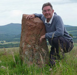
This remnant broch, also known as Upper Suisgill, seems only to have been discovered by the OS as recently as May 1961: it is not shown on any previous historical OS map.
Carn Nam Buth is extremely dilapidated, and while it has been categorised as a 'possible' broch on account of size, shape and position, it may simply have been a ditched homestead or dun. It occupies the summit of an impressive knoll that has been artificially steepened, and which would have provided an easily defended position overlooking cultivable land, immediately north of the A897 Kildonan road and 180 metres east of the bridge over the Suisgill Burn.
A visit entails an easy uphill walk over grass to a largely heathery dome showing little remaining structure apart from a hint of foundation course on the southeast flank.
|
Visited: June 28, 2018
Immediately below the hill of Baile Mhargaite, with its summit broch, lie the remains of a Bronze Age village and burial ground on a sandy plateau some 15 metres above sea level. The plateau undulates a little and includes a number of hut circles and three cists.
The main cist, by far the best preserved of the three, lies at NC 69863 61030, sunk into the summit of a mound (cairn ?) about 2.5 metres tall. The cist, measuring 107x56x51 cm, is perfectly preserved, and open (its capstone lies just to one side of it), and is lined on all sides with flagstones.
Just a few metres away at NC 69856 61027 is a second open cist with one end flagstone and its cover both absent.
The third cist lies in level ground some 22 metres north of the first two at NC 69847 61051. It has no capstone, both end flagstones are missing, and the crypt has infilled with sand.
|
Visited: June 26, 2018
Canmore dramatically describes Dun Carnachaidh as: 'The remains of a broch on a cliff overlooking the river valley'!
What cliff?
There's no cliff within sight, and the broch stands just 90 metres west of the Strathnaver road up a steepish grassy hillside.
This broch cannot be seen from the road as it sits on a level shelf about 25 metres up the hillside. It takes but a few minutes to reach it. It is extremely ruinous with few major features extant. The foundation course can be followed intermittently around the structure and there are some impressively large stones of the 2nd course around the southeastern arc. Amongst the tumble to the west of the broch is what appears to be the remains of an intra-mural gallery.
Access to Dun Carnachaidh is straightforward as there is parking in a bay beside a cattle grid on the road just 1½ kilometres north of Carnachy. The fence at the roadside consists only of wire strands which it is easy to wriggle between (no barbed stuff).
|
Visited: June 25, 2018
Located no more than 3 km west of the A9, and not far from the town of Golspie on the Dornoch Firth, Backies must rate as one of the 'must see' brochs of northern Scotland. Considered to be a solid-based broch, Backies was excavated in 1846, and the spoils simply tossed over its walls to form a stoneheap all around it. In this respect, its profile is almost identical to that of Carrol Broch. Backies stands on a steep rocky knoll just north of the community of the same name, and the only feature evident from outside is the 5 metre long entrance passage and the entrance portal itself, surmounted by a huge lintel.
But the interior is another matter altogether. The foundation course is completely buried in rubble but
the second level is virtually complete and still stands 2½ metres tall round the entire structure with a well preserved ledge scarcement at 1.7 metres. The second level is hollow, and a well constructed doorway leads into the intra-mural cavity. A feature of the doorway is a lintel below the top which serves as part of the scarcement ledge.
Canmore states that: "Backies is a good example of a once well preserved, hollow-walled broch which is steadily falling into ruin. Only its remoteness has preserved it from greater destruction, but there can be little doubt that in a few more decades all the surviving traces of hollow-wall architecture in Level 2 will have disappeared." There is a huge amount of information about Backies broch on the Canmore website.
To access Backies broch, look out for a sign indicating left to 'Backies' just a few hundred metres north of Golspie as you drive north on the A9, and mid-way between Golspie and Dunrobin Castle. Follow this road for 2½ km till you encounter a sign pointing right to a Scottish Water Treatment Works (marker 'W' on the map). There is room for one car to park on the verge just before this sign. Head up the road to the Treatment Works, where there is a possibility of parking just past their building on the right (marker 'P').

From the Treatment Works, walk up the road for 80 metres or so till you encounter a well constructed sinuous road heading to the right (east). The road ends at a ruined croft house in sight of Backies broch (yellow line). Although the terrain towards the broch (marker 'B') looks a bit of a jungle of woodland thickets and bracken there is a narrow footpath to it (though I missed it and had to fight my way round to the broch).
On the road's final bend, just a few metres before the ruined croft house, a drainage culvert passes under the road. The path to the broch, which I only discovered on the way back from it, starts immediately before the culvert and heads in nearly a straight line to the broch (cyan line on map). In summer, it's just a case of searching for the trampled path beneath the bracken and following it as best possible.
|
Visited: June 28, 2018
To visit this broch (which lies about 4½ km west of Kilphedir) park on the verge beside a large stone walled enclosure to the south of the road through the Strath of Helmsdale at NGR NC 945 188. The broch cannot be seen from the road, but it lies only about 100 metres uphill. Across the road, a path heads uphill towards a gate bearing a notice that this is part of the Suisgill Estate. Pass through the gate and follow the path uphill, looking to the right for the pile of rubble that signifies the remains of Balvalaich broch, and cut across to it.
Balvalaich broch is severely denuded, having been quarried for stone when the original road was laid through the strath. All that remains in the interior is a wilderness of small stones. Nevertheless, both inner and outer wall faces can still be traced, with some particularly large foundation course stones surviving on both the southwest and eastern quadrants.
|
Visited: June 28, 2018
When you visit Dun Viden broch you will undoubtedly also encounter the Orkney-Cromarty type Neolithic chambered cairn of the same name; in fact, you will most probably walk over it as you leave the path.
Visually, the site appears to be a set of large stones resting on the top of a heather-clad mound. These are residual chamber slabs from the severly robbed tomb. The small stones that once covered the cairn are long gone, and it is surmised that they may well have been used in the construction of the nearby broch.
Canmore adds that: " ... the cairn has been removed and its edge cannot be traced, although the situation dictates that it could not have been more than 11 metres in diameter. The chamber has been about 3 metres wide and entered from the east".
|
Visited: June 25, 2018
No journey up the Strath of Kildonan would be complete without inspecting the impressive remains of Kilphedir broch. Invisible from the roadside, the broch sits 90 metres up the hillside just east of the Allt Cille Pheadair (Kilphedir burn), and about four kilometres from Helmsdale. There is ample parking at the bridge over the burn, from where a rough land rover track leads uphill, soon revealing the broch as a huge pile of tumbled masonry perched on a knoll some 400 metres to the east. The broch is surrounded by outworks consisting of a deep ditch, an outer rampart wall over 3 metres wide, and an outer ditch, well illustrated by Greywether's photograph.
The external wall face is completely hidden beneath tumbled masonry, the only feature remaining being the entrance passage on the northwest—almost five metres long—where three lintels remain in place. The interior on the other hand displays much of interest with walls four metres thick rising to eight courses around most of the structure's circumference.
There is a doorway leading into an intra-mural passage where a stairway (no longer evident) was reported early in the 20th century.
You can learn much more about this broch by following this link to the Canmore website.
|
Visited: June 28, 2018
Dun Viden lies in Strathnaver, some ten kilometres south of Bettyhill and just 250 metres to the east of the River Naver. It can be reached by driving to the end of the metalled road to Skelpick, then walking an excellent (though rough in places) estate road for a further 4 km. As the broch comes into view, you will be aware of a number of standing stones just west of the road, the only surviving evidence of a Neolithic Tomb. At this point, cut across the heather to the broch.
The broch sits atop a grassy, twenty metre tall, conical knoll which slopes steeply down on all sides except the east. The structure has been severely robbed, almost certainly to aid construction of the Settlement (a so-called 'Clearance Village') that still stands immediately adjacent to the southeast of its knoll.
Although badly ruined, Dun Viden still has a recognisable entrance passage to its southeast, but most of the walling and interior have been reduced to a field of amorphous rubble. There are, however, a few places where large foundation level stones along the external wall face can still be seen.
Dun Viden must have been a great look-out point in its day; and remains so.
|
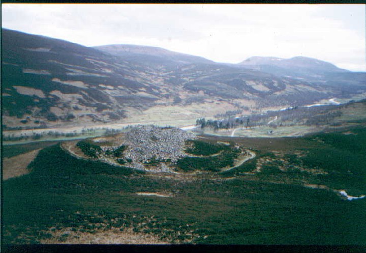
Visited: June 26, 2018
June 2018 proved to be an exceptionally good time to visit Dun Creagach. Normally perched on a small island, and accessible only via a causeway of rough boulders, the drought had so lowered the waters of Loch Naver that I could actually walk completely round the broch on the dried-out loch bed without fear of getting a boot wet!.
Dun Creagach is huge and mighty impressive. Possibly because of its relatively remote location, stone-robbing does not seem to have been an issue here, as evidenced by the unusually large quantity of tumbled masonry that buries much of the broch's outer walling: certainly there are no dykes or signs of former habitation—so often the prime reason for destructuring—anywhere nearby. Of course, over the centuries, Nature has taken her toll in the shape of vast heaps of tumbled stone, mainly outside the structure. Even so, the broch walls still tower to over three metres almost everywhere around its periphery, and everywhere, the outer face stands at least a metre above the surrounding tumble.
Despite the all-encompassing rubble, there is a lot to see in the interior of the broch. The largely blocked entrance passage with its massive inclined lintel, a large almost square doorway that leads into the intra-mural galleries, and several locations where gaps in the tumble suggest strongly a void within the walls. Indeed, Canmore states that Dun Creagach "is certainly a true hollow-walled broch".
Dun Creagach can most easily be accessed from Altnaharra, from a point just south of the village, walking up the road that heads to Klibreck Lodge. Just 50 metres south of this point, on the A836, is an enlarged passing place, where there is room to park several cars without compromising its use by road traffic.
The distance to the broch is almost exactly 4 km, the first 1.5 km on a metalled road as far as the Lodge. On reaching the Lodge, head right for a few meters then left round the building to a field gate and continue along a good dirt road that continues east. Two streams (marked 'ford' on the OS map) are actually now crossed by footbridges before the path peters out at the edge of a wooded plantation.
Now comes the tricky part: It is important to continue due east through woodland to a third stream. This is where I came unstuck, losing direction and heading away from Loch Naver. On reflection, I might have been better following the second stream to the shore, then continuing along the lochside to the broch.
In all, it took just an hour and a quarter to reach Dun Creagach, but underfoot conditions were particularly easy with the ground being parched: there were none of the usual bogs to negotiate.
This is a broch for the connaisseur, with much to see and enjoy. It takes more than the usual effort to make its acquaintance—a round trip on foot of some eight kilometres—but has so much to offer in return.
|
Visited: May 2, 2018
Some 250 metres due north from the car-park opposite Trumpan Churchyard lie the remains of a small promontory fort called Sgoir Beag. From the car-park head northeast up the road for about 130 metres till you cross a stream then immediately enter the field on the left via the gate. Follow the stream which dives down to the sea immediately adjacent to the fort.
The grassy rise ahead quickly leads to a deep natural ditch which cuts off the dun from the east. Descent into the ditch is easy but the face of the dun rises much more steeply beyond. A well worn path to the left eases the climb to the top of the dun, overlooking the precipitous drop into the stream valley.
The surface of the dun is a grassy oval, with only a small fragment of walling, two courses high, showing at its nothern edge.
|
Visited: May 2, 2018
Skye's Waternish peninsula is best known for its three brochs: Dun Hallin, Dun Gearymore and Dun Borrafiach. But near the community of Geary on its eastern coast, unmarked on the OS map, lie the scant remains of Geary Promontory Fort.
Canmore's notes from 1990 state:
This fort is situated on a small promontory on the precipitous cliffs towards the N end of the Geary crofts; it is defined by an arc of walling 4m thick and 0.75m in height that cuts across the promontory and line of the cliffs to the E, N and S providing protection on these flanks. At the S end the wall does not run up to the cliff edge, and although the N end is now wasted it can be traced up to the edge of the cliff.
At the time of my visit it was hard to believe that any defensive wall existed. But the location of the site was absolutely confirmed by GPS: I was definitely on the correct promontory.
The promontory is totally overgrown, in part by semi-mature thickets of shrubbery and elsewhere by rank grass and vegetation. I could find no coherent evidence of any protective wall: just a couple of large boulders, an earthfast moss-covered stone, and what appeared to be a thickly vegetated rampart which stretched across around a third of the neck of the promontory.
The only redeeming feature of this site is the views it gives across Loch Snizort to the Ascrib Islands, and northwards along the rugged Waternish coastline.
If visiting by car, parking places are non existent. However a helpful local told me to 'just park in a lay-by'. As there is no through traffic in Geary, the temporary loss of one lay-by for parking is of no great consequence as everyone living there has parking on their properties.
|
Visited: April 29, 2018
About half a kilometre south of Flodigarry, on the A855, you pass Lochan nan Dunan, a small roadside lochan with a parking area beside it. Immediately on the right hand side of the road (if travelling north) is a heathery hillside rising steeply for about 15 metres. A stout barbed wire fence precludes immediate access opposite the parking area, but walking back down the road for 50 metres or so revals twin boulders arranged to form a stile.The fort of Lochan nan Dunan is revealed after making this short climb.
The fort comprises two enclosures, separated by a mighty rock stack twelve metres in height. There is little of real note to see although the grassy stumps of the enclosing wall of the eastern enclosure, little more than half a metre in height, can still be picked out. The western enclosure, located on a gentle slope, boasts an even less significant grass-grown wall.
The best part of the visit is the view it provides towards the mountainous backbone of the Trotternish peninsula. Particularly prominent is Sron Vourlinn, the gaunt flat topped hill to the northwest, and the Quiraing to the southwest.
|
Visited: April 29, 2018
Near the farthest northeast point of Skye's Trotternish peninsula lies Kilmaluig Bay with its mighty Stac Lachlainn, a sea stac of truly immense proportions that towers above the clifftops. And immediately adjacent to the stac, to its northwest, is a small promontory on which stand the ruins of Skye's northernmost fort, Dun Aird.
Like many if its ilk, little of the structure of Dun Aird has survived to the present day other than an obvious grassed bank to the west that is all that remains of its walls and a hint of facing stones on the approach to the crag from the gate in the fence. The interior is generally level and grassed over, sloping noticeably down towards the sea.
As with such eyries, the main pay-off comes with the views the dun affords, specially on a sunny day, when the shallow coastal waters of Kilmaluig Bay glisten with myriad hues. To the north the sea stretches off towards the North Pole, but the finest views are southward, towards Stac Lachlainn and the mountainous spine of the peninsula.
Access to the dun seems fraught by fences from all directions. There is certainly a coastal path skirting the bay, and though it is clearly well worn, it still requires the negotiation of at least three stout, gateless barbed wire fences. The other option is to take the metalled road up from the bay for a few hundred metres and then branch to the right past Aird House. This road ends at a gate that leads on to the moor. From here the dun and stac are due east, but again there are fences to negotiate (but no definite path to take - unless I missed it). Finally you arrive at the fence cordoning off the clifftops, which does, thankfully, offer an access gate immediately above the dun.
For the motorist, there is a car-park at Kilmaluig Bay.
|
Visited: May 2, 2018
The rarely visited fort of Meall An Duna stands of a low, crag girt ridge west of Greshornish Hotel and some hundred metres from the shore of an attractive unnamed lochan. Little of the structure remains but the broad vegetated northern arc of its surrounding wall still stands around a metre in height with facing stones peeking out intermittently. At the east of the dun a level rising path leading to the summit might be the entrance passage. On reaching the fort, the reward for the intrepid adventurer is a wonderful view to the east, encompassing Loch Greshornish and the Trotternish mountains beyond.

From the end of the metalled road, just west of the Greshornish House Hotel, a dirt road heads west and curves northward for 250 metres towards a small stand of mature trees. Here, another path branches west through a gate, for about 180 metres, and through a second gate, till it meets a fence line heading due south. Just follow the west side of the fence for 250 metres and you arrive at the foot of the crag bearing the fort of Meall an Duna (marker 'F').
|
Visited: April 29, 2018
Surely few megalithic monuments in Britain can be found in such stunning surroundings as this diminuative dun, just 200 metres north of Loch Leum na Luirginn in Skye's Trotternish peninsula. Nestling just east of the spectacular Trotternish mountains there are views to the pyramidal Cleat in the south while northward rise the precipitous cliffs and pinnacles of the Cuiraing.
The dun itself lies 150 metres south of the Brogaig to Uig road, behind the modern cemetery, itself about two kilometres from Brogaig (not the old cemetery adjacent to the community). From the cemetery gate, follow the fence line south outside the cemetery as far as the unnamed stream that flows east into the River Brogaig. Step across the stream where the slope rises steeply for some 20 metres (too steeply to consider an ascent), and follow a path that follows the stream to the right (west) towards easier heather clad slopes where an ascent can be made.
All of a sudden you emerge on a plateau with the loch and Cleat prominent, and the site of the dun is obvious as a low, grassy platform amongst the heather. The dun stands at an altitude of 149 metres and has clearly been severely robbed. Nonetheless, though heavily vegetated, its outline is clear, with a pronounced saucer-shaped depression within. Inside the dun sufficient stonework can be seen to surmise that two or three courses of foundation blocks probably lurk beneath the tussocks of grass.
|
Visited: May 2, 2018
The location of this cairn, according to Canmore, lies at the junction of two dykes on a gentle rise directly southeast of the graveyard of Trumpan Church and just 60 metres distant from the back wall of the cemetery.
There is absolutely no mistaking the location, but the site is so completely trashed that there is little evidence of a cairn now. There are a few moss covered stones that could be the remnants of a kerb, but no clear rise in the topography into the 'V' between the two dykes.
|
Visited: April 29, 2018
Dun Connavern sits just 2½ kilometres south—as the crow flies—of the well-known Loch Mealt Kilt Rock viewpoint.
The starting point for the one kilometre walk to Dun Connavern is from the prominent roadside sign on the A855 advertising the Ben Edra Hotel at NG 5144 6341. Here, a small section of old road near the entranceway affords a parking space (marker 'P').
Next, walk 50 metres north along the main road to the sign for the Taigh nam Brathrean self-catering cottage and follow the path that leads between it and the hotel to a gate (marker 'G').

The path beyond this gate, though overgrown, still provides excellent walking, and continues for some 250 metres before curving left (south) for a similar distance before finally making a sharp turn to the right. From here, a prominent fence-line leads directly to Dun Connavern (marker 'D'), first ascending a very steep but short grassy slope, 100 metres beyond which, at an altitude of 140 metres, lies the dun, on the summit of an oval rocky knoll.
Little structure remains of the encircling walls of Dun Connavern, save for a section of walling blocks, two courses high, on its northeast facing slope. But visiting the dun is greatly rewarding, its modest elevation providing unsurpassed views towards the Trotternish mountains from the Storr in the south to the Cuiraing in the north.
|
Visited: April 20, 2018
Crabs Cairn Revealed
With summer in full flow I spent the morning enjoying a ramble round the Tullos Hill Cairns in Aberdeen. And I was delighted to note that major removal of gorse thickets had at last opened up Crab's Cairn to view.
The offending undergrowth had been sawn off about 15 centimetres above ground level, and completely removed from the site. My only complaint is that the remaining stumps of the gorse bushes now represent a significant 'trip hazard' for the unwary.
Hopefully, further work to render this site visitor friendly will be undertaken before long.
|
Visited: January 20, 2018
I have visited Clune Hill and its Recumbent Stone Circle more times than I can remember over the years. When time is limited, the forest walks surrounding this site provide atmospheric short excursions. But what seems to have escaped the notice of most contributors to TMA is the ring cairn immediately adjacent to the east of the RSC. A couple of photographs of the cairn do appear on the RSC page, but surprisingly, this site has hitherto received no fieldnote.
Clune Hill Ring Cairn extends some ten metres in width and rises to around ¾ metre in height, but because of the uneven nature of the terrain here—covered with tussocks of grass and heathery hummocks, not to mention the ever-encroaching bracken—only the neat central chamber catches the eye: the edges of the cairn are ill-defined and there is no outer kerb to be seen.
There is a fine image from 'Greywether' which shows the central chamber of the Ring Cairn in 2005 when it appeared to have recently been cleared of vegetation.
This chamber, largely overgrown by heather and bracken, particularly during the summer months, has been built of irregular, rounded stones, which are particularly prominent in the northeast quadrant. The almost continuous kerb consists of graded boulders which increase in size and height towards the southwest: the tallest kerbstone, at 0.8 metres in height, stands on the SSW and the smallest on the NE. There is a gap in the kerb towards its south, about three metres from the nearest stone of the RSC (orthostat No 4), but Aberdeenshire Council's website describes the ring cairn as 'incomplete', and states that there is no evidence for a passage leading to the cairn edge.
|
Visited: May 23, 2017
The existence of this 'possible' stone circle was announced following a Discovery and Excavation in Scotland exploration on Skye's Strathaird estate in 1998. Don't go expecting to see a monumental structure: like most of Skye's stone circles, there is really very little remaining.
The site is located half a kilometre north of the small community of Drinan, situated half-way down the western margin of Loch Slapin. To visit, step on to the moor immediately north of the cattle grid (on the road, just before entering Drinan) and head north for 450 metres, uphill of the fence (you will have to park down in the village). The walking is excellent on firm, short heather and there are no fences to cross.
Make for the slightly higher ground and look down. The circle occupies a conspicuous grassy spot in the otherwise dark heather of the moor, about 40 metres west of the fence line. Three earthfast stones stand on the southern arc of the slightly raised grassy oval: the rest of the perimeter is devoid of stones. A trickle of stream runs close by it.
This location is about 30 metres northwest of the Grid location quoted by Discovery and Excavation in Scotland. However, I don't consider this significant: after all, the Grid reference they gave for the Cuidrach Stone Setting in 1989 proved to be more than a hundred metres in error.

The walk to the site is rather featureless but, as the map above shows, there is a slight 'greening' of the vegetation where the small stream trickles down past the circle. Also, looking east towards the loch, you should be level with a band of trees that straddles the path to the cottage beyond.
|
|
A keen hillwalker most of my life, my interest was restricted when the need arose to care for an ageing parent.
With limited opportunities to travel far from home, I 'discovered' the world of stone circles, mainly in my native Aberdeenshire.
This provided the ideal opportunity for short walks of just a few hours duration, and resulted in me visiting many places of interest that I had never considered previously.
Website:
Stone Circles of NE Scotland
Here you will find both Google and Bing maps displaying more than 100 sites of stone circles, the majority in my native Aberdeenshire. The markers on the maps are clickable, to reveal a photo of the stone circle and a link to their Canmore Site Record.
A menu at the side of the maps allows you to zoom in to any individual circle, viewing its environs as a zoomable aerial photograph (Google) or an OS Map (Bing).
Hunebedden
I've since extended my interest to the megalithic remains in The Netherlands, where there are some magnificent passage graves known as hunebedden (giant's beds). Despite the fact that The Netherlands is essentially flat and sandy, these 5000 year old monuments from the Funnel Beaker Culture are often found in exquisite woodland settings, nearly all of them in the province of Drenthe. There are almost limitless opportunities for delightful walks between small villages, taking in a diversion to a hunebed here and there.
|
