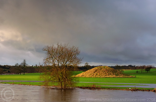
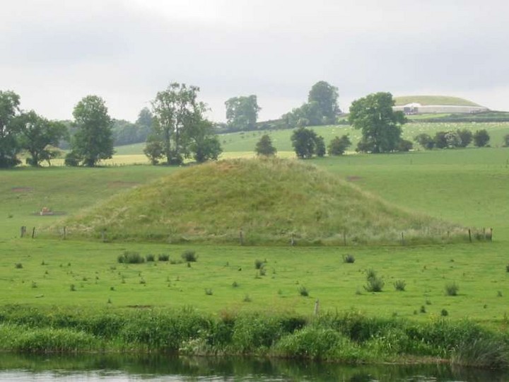
Log in
|
Register
Home
Latest Posts
Forums
Maps
Help
Browse Sites
News
Blog
Contributors
The Books
Select
-
Belgium
Denmark
Eire
France
Greece
Italy
The Netherlands
Norway
Portugal
Republic of Malta
Spain
Sweden
Switzerland
United Kingdom
County Meath
Boyne Valley Complex
Newgrange
Newgrange Tumulus B
Passage Grave
Newgrange Tumulus B (Passage Grave) on The Modern Antiquarian, the UK & Ireland's most popular megalithic community website. 2 images, plus information on many more ancient sites nearby and across the UK & Ireland.
Image © ryaner
Nearest Town:
Duleek (5km SE)
OS Ref (IE):
O016722 /
Sheet: 43
Latitude:
53° 41' 22.57" N
Longitude:
6° 27' 42.7" W
Added by
ryaner
Images (2)
0 discussions
Start a topic
Show |
Hide
Web searches for Newgrange Tumulus B
Flash Earth
Flickr
Google
Google Images
The Megalithic Portal
Multimap 1:25000
Stone Pages
Wikipedia
Show map
(inline Google Map)
- Sites within 20 km -
-
Hedgerow Stone (0.3km N) (2 posts)
Newgrange Tumulus A (0.45km W) (2 posts)
Newgrange Cursus (0.86km WNW) (2 posts)
Newgrange (1.06km W) (92 posts)
The Great Circle (1.11km W) (12 posts)
Newgrange Standing Stone C (1.11km W) (6 posts)
Dowth Mound II (1.17km NNE) (0 posts)
Newgrange K & L (1.2km W) (10 posts)
Dowth Mound III (1.25km NNE) (0 posts)
Dowth I (1.74km NNE) (44 posts)
Dowth (1.74km NNE) (3 posts)
Dowth II (2.2km NE) (0 posts)
Dowth Mound I (2.27km NE) (0 posts)
Knowth (2.32km W) (103 posts)
Longford (2.66km ESE) (0 posts)
Dowth Henge (2.68km NE) (5 posts)
Cloghalea (2.98km NE) (6 posts)
Monknewtown II (3.39km NNW) (3 posts)
Monknewtown (3.44km NW) (0 posts)
Rossnaree (3.5km WSW) (0 posts)
Littlegrange (3.56km N) (6 posts)
Townley Hall Souterrain (4.23km NNE) (0 posts)
Townley Hall Barrow (4.6km NNE) (0 posts)
Gallows Hill (5.18km W) (0 posts)
Stanley Hill (5.26km W) (0 posts)
Johnstown (5.39km WSW) (0 posts)
Hill of Slane Souterrain (5.71km W) (0 posts)
Mellifont (5.8km NNW) (0 posts)
Hill of Slane Barrow (6.28km W) (1 post)
Painestown (6.58km WSW) (0 posts)
Bellewstown (6.79km ESE) (0 posts)
Gaulstown (6.81km SSE) (3 posts)
Rathmaiden (7.48km WNW) (0 posts)
Hilltown Little (7.94km ESE) (0 posts)
Boolies Great (7.96km SE) (0 posts)
Bey More (8.21km ENE) (0 posts)
Drogheda (8.35km ENE) (0 posts)
Danestown Ringfort (8.43km SSW) (4 posts)
Gernonstown (8.85km W) (0 posts)
Realtoge (9.51km WSW) (0 posts)
Kingstown & Carnuff Great (9.61km WSW) (1 post)
Davidstown Barrow (9.86km W) (0 posts)
Gerrardstown (10.3km SW) (0 posts)
Balgeeth (10.46km SE) (2 posts)
Fieldstown Hill (10.61km NE) (0 posts)
Mullagharoy (10.61km WNW) (4 posts)
The Stuck Stone (11km WNW) (0 posts)
Paddock (11.4km NNE) (3 posts)
Mount Oriel (11.59km NW) (3 posts)
Moorepark (11.59km SE) (0 posts)
Slieve Beagh (11.71km WNW) (5 posts)
Mullahteelin (11.74km E) (0 posts)
Dunmore (11.79km NW) (0 posts)
Roadmain (11.98km SSE) (0 posts)
Heathtown Henge I (12.25km ESE) (0 posts)
Greenanstown (12.4km ESE) (0 posts)
Piperstown (12.4km NE) (1 post)
Piercetown (12.47km SSE) (0 posts)
Clonardran (12.48km SW) (0 posts)
Heathtown Henge II (12.56km ESE) (4 posts)
Heathtown Mound (12.63km ESE) (2 posts)
Belpatrick (12.85km NW) (0 posts)
Herbertstown (13.08km ESE) (0 posts)
Drumshallon (13.14km NE) (0 posts)
Mullaghash (13.17km NW) (2 posts)
Mullaghash (13.17km NW) (3 posts)
Micknanstown (13.2km ESE) (2 posts)
Garlagh (13.2km SW) (0 posts)
Rath Lugh (13.31km SW) (3 posts)
Lismullin (13.39km SW) (7 posts)
Milltown (13.4km NE) (0 posts)
Fourknocks (13.69km ESE) (22 posts)
Rathbran More (13.71km WNW) (6 posts)
Laytown (An Inse) (13.87km E) (5 posts)
Blundelstown (13.89km SW) (0 posts)
Fourknocks (13.9km ESE) (2 posts)
Primatestown (14.01km SSE) (0 posts)
Collierstown (14.06km SSW) (0 posts)
Baltray (14.31km ENE) (7 posts)
Termonfeckin (14.32km ENE) (0 posts)
White Mountain (14.33km NW) (0 posts)
Corracon (14.38km NW) (0 posts)
Windmill Hill (14.39km SSE) (0 posts)
Kilbrew (14.68km SSE) (3 posts)
Rathkenny (14.79km W) (0 posts)
Hodgetown (14.85km ESE) (0 posts)
Cabragh (15.01km SW) (0 posts)
Garristown (15.09km SE) (0 posts)
Newtown (15.12km SSE) (0 posts)
The Banqueting Hall (15.48km SW) (4 posts)
Tullog (15.51km ESE) (0 posts)
The Sloping Trenches (15.53km SW) (1 post)
Grainne's Enclosure (15.53km SW) (1 post)
Churchyard Stones (15.66km SW) (4 posts)
The Barrows (15.78km SW) (0 posts)
Rath of Synods (15.78km SW) (4 posts)
The King's Seat (15.86km SW) (9 posts)
Cormac's House (15.86km SW) (3 posts)
The Royal Enclosure (15.86km SW) (1 post)
The Mound of Hostages (15.86km SW) (15 posts)
Lia Fail (15.86km SW) (10 posts)
Rath Laoghaire (15.94km SW) (0 posts)
Knockdinnin (16.1km N) (0 posts)
Dardisrath (16.15km ENE) (0 posts)
Purcellstown (16.53km NW) (0 posts)
Blakestown (16.54km NW) (0 posts)
Roestown (16.55km NNW) (0 posts)
Walshestown (16.62km NE) (0 posts)
Rath Maeve (16.68km SW) (0 posts)
Hurlstone (16.92km NW) (2 posts)
South Stone (17.02km NNW) (2 posts)
Barnaveddoge Mound (17.13km NNW) (0 posts)
North Stone (17.2km NNW) (0 posts)
Knocknagin (17.2km E) (1 post)
Trevet (17.22km SSW) (3 posts)
Knocknagin Beach (17.55km E) (0 posts)
Mullameelan (17.71km NW) (0 posts)
Arch Hall (17.85km W) (6 posts)
Skeaghmore (18.16km NNE) (0 posts)
Mallahow (18.2km ESE) (0 posts)
Labanstown (18.46km NE) (0 posts)
Kichenstown (18.5km ESE) (0 posts)
Knockbrack (18.64km ESE) (0 posts)
Knockbrack (18.76km ESE) (0 posts)
Bremore (18.97km E) (19 posts)
Clogher Head (19.7km NE) (0 posts)
Nags Head (19.82km ESE) (0 posts)
- Add -
-
Add news
Add an image
Add fieldnotes
Add folklore
Add miscellaneous
Add a link
-
Add a site
Add a nearby facility
Add an alternative name/spelling
Images
(click to view fullsize)
Add an image