Log in
|
Register
Home
Latest Posts
Forums
Maps
Help
Browse Sites
News
Blog
Contributors
The Books
Select
-
Belgium
Denmark
Eire
France
Greece
Italy
The Netherlands
Norway
Portugal
Republic of Malta
Spain
Sweden
Switzerland
United Kingdom
Scotland
Orkney
West Mainland
The Howe
The Howe
The Howe on The Modern Antiquarian, the UK & Ireland's most popular megalithic community website. 2 images, 1 fieldnote, plus information on many more ancient sites nearby and across the UK & Ireland.
Image © wideford
Nearest Town:
Stromness (3km SW)
OS Ref (GB):
HY276109 /
Sheet: 6
Latitude:
58° 58' 45.61" N
Longitude:
3° 15' 34.53" W
Added by
wideford
Images (2)
Fieldnotes (1)
Miscellaneous (1)
0 discussions
Start a topic
Show |
Hide
Web searches for Howe
Flash Earth
Flickr
Google
Google Images
MAGIC
The Megalithic Portal
Bing
Stone Pages
Streetmap.co.uk
Wikipedia
Show map
(inline Google Map)
- Sites within 20 km -
-
The Howe (0km N) (5 posts)
The Howe (0km N) (11 posts)
Cummi Howe (0.82km E) (17 posts)
Deepdale (0.91km WNW) (16 posts)
Point of Onston (1km NE) (3 posts)
Unstan (1.06km NE) (53 posts)
Corn Hillock (1.15km ESE) (8 posts)
The Cairns, Hall of Ireland (1.77km E) (5 posts)
Quoyelsh (2.28km SW) (9 posts)
Nether Bigging (2.68km ENE) (2 posts)
Standing Stones Hotel (2.81km ENE) (5 posts)
Salt Knowe (2.93km NE) (9 posts)
Ring of Brodgar (3.07km NE) (127 posts)
Wasbister Disc Barrow (3.08km NNE) (16 posts)
Comet Stone (3.14km NE) (25 posts)
Fresh Knowe (3.19km NE) (8 posts)
Quholm, Burn of Una (3.2km W) (12 posts)
Plumcake Mound (3.21km NE) (6 posts)
Bookan Cairns (3.26km NNE) (24 posts)
Lochview (3.29km ENE) (25 posts)
Wasbister Cairn (3.29km NNE) (10 posts)
Ness of Brodgar (3.35km ENE) (25 posts)
Bookan (3.38km NNE) (19 posts)
The Watchstone (3.44km ENE) (21 posts)
The Standing Stones of Stenness (3.48km ENE) (81 posts)
The Brecks (3.54km NNE) (56 posts)
Skae Frue (3.54km N) (11 posts)
Stone of Odin (3.57km ENE) (14 posts)
Barnhouse Settlement (3.66km ENE) (33 posts)
Ring of Bookan (3.68km N) (23 posts)
Barnhouse Stone (3.91km ENE) (8 posts)
Stackrue-Lyking Mound (4.22km NNW) (6 posts)
Stackrue Broch (4.23km NNW) (21 posts)
Voy (4.36km NW) (29 posts)
Voy (4.47km WNW) (5 posts)
Harray Viewpoint (4.51km NE) (8 posts)
Maeshowe (4.55km ENE) (64 posts)
Brockan (4.67km WSW) (12 posts)
Burrian Broch (4.67km NNE) (2 posts)
Leafea (4.76km WSW) (18 posts)
Grimston (4.87km NE) (10 posts)
Burn of Cruland (4.95km WNW) (3 posts)
Vola (4.97km NE) (18 posts)
Via Mound (5.24km NW) (6 posts)
Via Mound (5.24km NW) (8 posts)
Breckness (5.33km WSW) (14 posts)
Stones of Via (5.33km NW) (6 posts)
Via Barrow (5.49km NW) (3 posts)
Shennar Howe (5.6km N) (1 post)
Pickaquoy (5.82km NE) (6 posts)
Lower Hobbister (5.83km ENE) (8 posts)
Loch of Clumly (6.08km NW) (5 posts)
Feolquoy (6.14km NE) (3 posts)
South Seatter (6.29km WNW) (3 posts)
Staney Hill (6.39km NE) (22 posts)
Henge (6.42km NE) (3 posts)
Staney Hill (6.44km NE) (17 posts)
Maesquoy (6.59km NE) (2 posts)
Dale (7.08km NE) (7 posts)
Hurkisgarth (7.13km NW) (2 posts)
Appiehouse (7.27km NE) (11 posts)
Angerow (7.28km WNW) (4 posts)
Hill of Heddle (7.35km ENE) (2 posts)
Brough of Bigging (7.43km WNW) (9 posts)
Knowe of Angerow (7.5km WNW) (13 posts)
Broch of Borwick (7.58km WNW) (19 posts)
Wasdale (7.68km ENE) (29 posts)
Burrian (Russland) (7.71km NNE) (5 posts)
Howe Harper (7.76km ENE) (12 posts)
Knowe of Nebigarth (7.91km WNW) (3 posts)
Loch of Skaill Niche (7.97km NW) (4 posts)
Nettletar (8.02km NE) (7 posts)
Knowe of Geoso (8.47km WNW) (12 posts)
Snaba Hill (8.47km ENE) (6 posts)
Harproo (8.78km ESE) (8 posts)
Gyre (8.88km ESE) (4 posts)
The Fairy Knowe (8.95km ENE) (53 posts)
Konger's Knowe (8.99km ESE) (18 posts)
Skaill road (9.01km WNW) (2 posts)
Skara Brae (9.08km WNW) (62 posts)
The Hillock (9.09km ENE) (12 posts)
Graystane (9.23km E) (8 posts)
Knowes of Trotty (9.24km NE) (10 posts)
Hillock of Breakna (9.61km E) (10 posts)
Burrian (Corrigall) (9.74km NE) (8 posts)
Skaill Church (9.82km NW) (2 posts)
Knowe of Verron (9.95km WNW) (24 posts)
Linnahowe (10.13km NW) (12 posts)
Knowe of Makerhouse (10.34km N) (2 posts)
Upper Garson (10.49km NW) (2 posts)
The Dwarfie Stane (10.95km SSW) (30 posts)
Nabban (11.49km ENE) (7 posts)
Ingshowe Broch (11.51km ENE) (17 posts)
Knowes of Yonbell (11.98km NW) (1 post)
Rennibister (12.16km ENE) (39 posts)
Wideford Hill (13.1km ENE) (10 posts)
Harraymen's Graves (13.12km NE) (1 post)
Knowe of Skorn (13.15km NW) (1 post)
Wideford Hill (13.3km ENE) (36 posts)
Spurdagrove (13.63km NNW) (1 post)
Ravie Hill (13.93km NNW) (3 posts)
Queena Fjold (14.09km NNW) (9 posts)
Quanterness (14.19km ENE) (5 posts)
Loch of Boardhouse (14.28km N) (2 posts)
Wideford (14.49km ENE) (8 posts)
Knowe of Nesthouse (14.77km N) (2 posts)
Crossiecrown (15.13km ENE) (3 posts)
Wheebin (15.54km NNW) (11 posts)
Lingrow (15.71km E) (10 posts)
Oxtro Broch (15.93km NNW) (15 posts)
Saverock (15.95km ENE) (11 posts)
Broch of Lingro (15.98km E) (25 posts)
Saverock (16.18km ENE) (15 posts)
Pickaquoy (16.44km ENE) (10 posts)
Crantit (16.45km E) (22 posts)
Grain Souterrain (16.55km ENE) (30 posts)
Nether Crantit (16.6km E) (6 posts)
St. Magnus's Well (16.67km NNW) (6 posts)
Stanerandy (16.69km NNW) (13 posts)
Newan (16.77km NNW) (7 posts)
Scapa (17.14km E) (5 posts)
Hillhead Well (17.19km E) (4 posts)
Hillhead Enclosure (17.2km E) (21 posts)
Tingwall (17.21km NE) (27 posts)
Mittens (17.38km N) (3 posts)
Knowe of Dishero (17.44km ENE) (12 posts)
Knowe of Buckquoy (17.54km NNW) (10 posts)
Knowe of Midgarth (17.57km NE) (10 posts)
Point of Buckquoy (17.65km NNW) (5 posts)
Point of Buckquoy (17.65km NNW) (10 posts)
Knowe of Crustan (18.06km NNW) (12 posts)
Knowe of Stenso (18.08km NE) (9 posts)
Knowes of Lingro (18.08km N) (3 posts)
Knowes of Lingro (18.08km N) (11 posts)
Crustan (18.16km NNW) (5 posts)
Knowe of Grugar (18.22km NNE) (7 posts)
Burgar (18.35km NNE) (10 posts)
Broch of Burgar (18.4km NNE) (4 posts)
Lower Arsdale (18.5km NNE) (1 post)
Peterkirk (18.77km NNE) (3 posts)
Costa Hill (18.85km N) (4 posts)
Broch of Gurness (19.06km NE) (32 posts)
The Five Hillocks (19.13km E) (6 posts)
Berstane Broch (19.86km E) (10 posts)
- Facilities within 20 km -
-
Mill of Eyrland (Bed & Breakfast: 2.8 km ESE)
Browns Hostel (Stromness) (Youth Hostel: 2.8 km SW)
Lochend (Holiday Cottage: 3.1 km ENE)
Stromness Youth Hostel (Youth Hostel: 3.2 km SW)
Point of NessCaravan a... (Camping Site: 3.5 km SSW)
Tormiston Mill (Cafe: 5.2 km ENE)
Atlantis Lodges (Holiday Cottage: 9.2 km ENE)
Kirkwall Youth Hostel (Youth Hostel: 16.8 km E)
The Kirkwall Hotel (Hotel: 17.3 km ENE)
Tankerness House Museum (Museum: 17.3 km ENE)
- Add -
-
Add news
Add an image
Add fieldnotes
Add folklore
Add miscellaneous
Add a link
-
Add a site
Add a nearby facility
Add an alternative name/spelling
Images
(click to view fullsize)
Add an image
Fieldnotes
Add fieldnotes
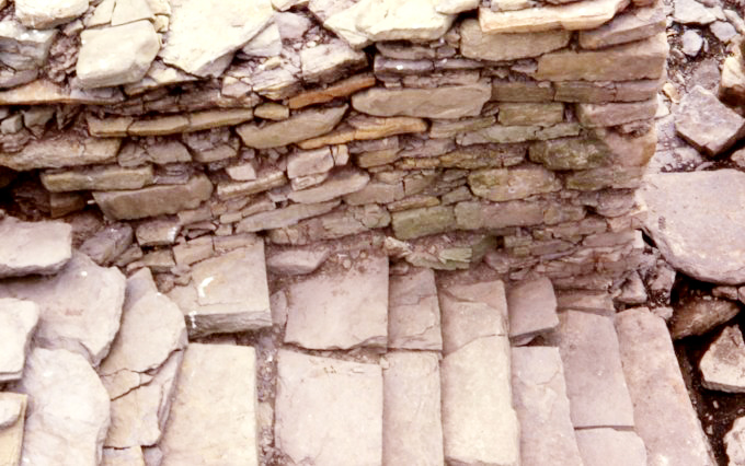
This is the broch that most people think of in association with the howe
Comments (0)
|
Add a comment
|
Permalink
Posted by
wideford
23rd December 2003ce
Miscellaneous
Add miscellaneous
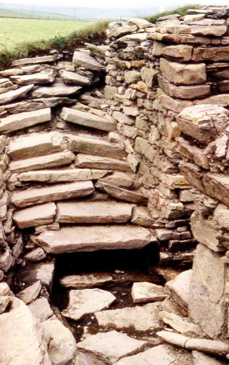
Some of the broch shows on pictures of the settlement
Comments (0)
|
Add a comment
|
Permalink
Posted by
wideford
23rd December 2003ce