The Modern Antiquarian
Log in
|
Register
Home
Latest Posts
Forums
Maps
Help
Browse Sites
News
Blog
Contributors
The Books
Select
-
Belgium
Denmark
Eire
France
Germany
Greece
Italy
The Netherlands
Norway
Portugal
Republic of Malta
Spain
Sweden
Switzerland
United Kingdom
County Tipperary
Knockalton Lower
Standing Stone / Menhir
Knockalton Lower (Lisbunny) (Standing Stone / Menhir) on The Modern Antiquarian, the UK & Ireland's most popular megalithic community website. 1 image, plus information on many more ancient sites nearby and across the UK & Ireland.
Image © Bawn79
Also known as:
Lisbunny
Nearest Town:
Nenagh (3km W)
OS Ref (IE):
R895786 /
Sheet: 59
Latitude:
52° 51' 29.82" N
Longitude:
8° 9' 21.25" W
Added by
FourWinds
Images (1)
2 discussion topics
Start a topic
Show |
Hide
Web searches for Knockalton Lower
Flickr
Google
Google Images
The Megalithic Portal
Bing
Stone Pages
Wikipedia
Show map
(inline Google Map)
- Sites within 20 km -
-
Rathurles (1.56km NE) (2 posts)
Rathfalla (1.98km NE) (5 posts)
Rathurles (2.24km NE) (9 posts)
Rathurles (2.39km NE) (6 posts)
Kilruane (4.7km N) (3 posts)
Tullahedy (5.96km WSW) (2 posts)
Knigh Hill (7.73km NW) (3 posts)
Kilcolman (7.97km W) (2 posts)
Middlewalk (8.14km NE) (3 posts)
Ashley Park (8.26km NNW) (3 posts)
Creggane (8.27km W) (2 posts)
Ashley Park (8.65km NW) (21 posts)
Ardcroney (8.82km NNW) (7 posts)
Ardcroney (8.95km N) (12 posts)
Corravalley (9.11km NNE) (3 posts)
Ballinacurra (9.28km SE) (1 post)
Coolagorane Upper (9.9km N) (5 posts)
Cooneen (10.32km SSE) (8 posts)
Ballinlough (10.51km E) (1 post)
Ballinlough (10.51km E) (2 posts)
Youghalvillage (10.75km W) (4 posts)
Foilnamuck (10.88km SSE) (10 posts)
Whitstone (11.01km NNW) (4 posts)
Foilnamuck (11.46km SSE) (5 posts)
Cooneen (11.63km SSE) (3 posts)
Bauraglanna (11.75km SSW) (9 posts)
Carrigeen (12km WSW) (7 posts)
Garranmore (12.2km W) (3 posts)
Lackamore (12.35km W) (3 posts)
Gorraun (12.37km NE) (7 posts)
Cloneygowny (12.42km W) (2 posts)
Coumroe (12.47km WSW) (4 posts)
Townfields (12.51km NNE) (3 posts)
Burgesbeg (12.51km WSW) (1 post)
Burgesbeg (12.88km WSW) (6 posts)
The Commons of Carney (13.35km NNW) (3 posts)
Lisheentyrone (13.41km W) (10 posts)
Lisheentyrone (13.44km W) (4 posts)
Knockanora (13.63km E) (4 posts)
Cureeny Commons (13.9km S) (17 posts)
Garrangrena Lower (14.22km ESE) (2 posts)
Ballyquinlevan Upper (15.09km NW) (3 posts)
Bendubh (15.54km ENE) (3 posts)
Knockaunreelyon (15.64km WSW) (2 posts)
Clonalough (16.02km SW) (2 posts)
Laghtea (16.04km WSW) (2 posts)
Glastrigan (16.07km SE) (13 posts)
Garraun (16.24km SW) (3 posts)
Garruan (16.24km SW) (1 post)
Cappadine (16.25km WSW) (5 posts)
Graves of the Leinstermen (16.26km WSW) (10 posts)
Ballymalone More (16.58km WSW) (2 posts)
Devilsbit Mountain (16.65km E) (6 posts)
Mauherslieve (16.81km S) (6 posts)
Mauherslieve (16.81km S) (1 post)
Toorfiba (17.15km SE) (3 posts)
Ballinahinch (17.43km SW) (1 post)
Ballinahinch (17.51km SW) (1 post)
Ballinahinch (17.55km SW) (2 posts)
Reisk (17.79km SSE) (1 post)
Ballina (18.04km WSW) (1 post)
Borrisnoe (18.13km E) (2 posts)
Borrisnoe (18.13km E) (5 posts)
Borrisnoe (18.13km E) (2 posts)
Knockcurraghbola Commons (18.47km SE) (22 posts)
Baurnadomeeny (18.67km SSW) (4 posts)
Ballynahinch (18.7km WSW) (1 post)
Knocknabansha (18.75km SSE) (5 posts)
Goulmore (18.78km S) (4 posts)
Baurnadomeeny (18.92km SSW) (6 posts)
Knockmaroe (19.03km SSE) (3 posts)
Ballynahinch (19.17km WSW) (2 posts)
Ballynahinch (19.17km WSW) (3 posts)
Baurnadomeeny (19.18km SSW) (38 posts)
Cooga (19.25km SE) (4 posts)
Cooga (19.25km SE) (2 posts)
Reardnogy More (19.26km SSW) (3 posts)
Roolagh (19.35km WSW) (5 posts)
Loughbrack (19.41km SSE) (11 posts)
Killawardy (19.57km E) (3 posts)
Knockcurraghbola Crowlands (west) (19.59km SSE) (8 posts)
Knockcurraghbola Crowlands (central) (19.62km SSE) (2 posts)
Knockcurraghbola Crowlands standing stone (19.71km SE) (3 posts)
Knockcurraghbola Crowlands (19.76km SE) (1 post)
Pestruper Gräberfeld (19.77km W) (9 posts)
Killaloe (19.79km WSW) (4 posts)
Knockcurraghbola Crowlands (east) (19.86km SSE) (2 posts)
- Add -
-
Add news
Add an image
Add fieldnotes
Add folklore
Add miscellaneous
Add a link
Add a nearby facility
Add an alternative name/spelling
Images
(click to view fullsize)
Add an image
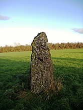 Image © Bawn79

