The Modern Antiquarian
Log in
|
Register
Home
Latest Posts
Forums
Maps
Help
Browse Sites
News
Blog
Contributors
The Books
Select
-
Belgium
Denmark
Eire
France
Germany
Greece
Italy
The Netherlands
Norway
Portugal
Republic of Malta
Spain
Sweden
Switzerland
United Kingdom
Wales
Pembrokeshire
Ramsey Island
Carnysgybor
Round Cairn
Carnysgybor (Round Cairn) on The Modern Antiquarian, the UK & Ireland's most popular megalithic community website. 1 image, plus information on many more ancient sites nearby and across the UK & Ireland.
Image © A. Brookes (26.7.2014)
Nearest Town:
Haverfordwest (27km E)
OS Ref (GB):
SM699246 /
Sheet: 157
Latitude:
51° 52' 18.93" N
Longitude:
5° 20' 34.81" W
Added by
thesweetcheat
Images (1)
0 discussions
Start a topic
Show |
Hide
Web searches for Carnysgybor
Flickr
Google
Google Images
The Megalithic Portal
Bing
Stone Pages
Streetmap.co.uk
Wikipedia
Show map
(inline Google Map)
- Sites within 20 km -
-
Carnllundain (1.3km S) (3 posts)
Lower Tregennis (2.13km E) (1 post)
Castell Heinif (2.45km ENE) (8 posts)
Clegyr Boia (3.93km ENE) (7 posts)
St David's Head Camp (4.01km NE) (31 posts)
Coetan Arthur (4.35km NE) (48 posts)
Carn Llidi Bychan (4.87km NE) (1 post)
Carn Llidi Tombs (4.87km NE) (38 posts)
St Nons (4.98km ENE) (16 posts)
Caerfai Camp (6.41km E) (15 posts)
Trecenny Stone (6.76km ENE) (11 posts)
Maen Dewi (8.11km ENE) (5 posts)
Porth-y-Rhaw (8.76km E) (9 posts)
Castell Coch (St David's) (9.53km NE) (7 posts)
Gribin (10.29km E) (8 posts)
Caerau (St David's) (10.82km NE) (10 posts)
Solva (10.96km ENE) (3 posts)
St Elvis (11.28km E) (27 posts)
Dinas Fawr and Porth y Bwch (11.43km E) (8 posts)
Llecha Cromlech (11.43km ENE) (2 posts)
Dinas Fach (12.73km E) (8 posts)
Tremaenhir (12.88km ENE) (2 posts)
White House, Llanhowell Cromlech (13.08km ENE) (8 posts)
Llanrhian (13.7km ENE) (3 posts)
Bickney Beacon (14.86km ENE) (1 post)
Newgale submerged forest (15km E) (4 posts)
Skomer (15.28km SE) (9 posts)
Harold Stone (Skomer) (15.28km SE) (5 posts)
Treffynnon (15.92km ENE) (7 posts)
The Nab Head (16.26km ESE) (2 posts)
Tower Point (16.44km ESE) (15 posts)
Deer Park (16.61km SE) (12 posts)
Castle Head (16.64km ESE) (7 posts)
Castell Coch (Llanrhian) (16.79km NE) (7 posts)
Howney Stone Rath (16.87km ESE) (7 posts)
Mill Haven Rath (16.88km ESE) (6 posts)
Carreg Samson (17.3km ENE) (67 posts)
Marloes Sound Rath (18.03km SE) (10 posts)
Tre Wallter Llwyd (18.27km ENE) (7 posts)
Grassholm (18.29km SSW) (3 posts)
Black Point Rath (18.52km E) (5 posts)
Gateholm (18.76km SE) (5 posts)
Harold Stone (The Havens) (18.92km E) (12 posts)
Upper Lodge Stones (19.13km E) (10 posts)
Castell Coch (Mathry) (19.98km ENE) (6 posts)
- Facilities within 20 km -
-
The Farmer's Arms (Pub: 5.2 km ENE)
The Cartref (Restaurant: 5.4 km ENE)
Caerfai Bay Caravan & ... (Camping Site: 5.7 km ENE)
Caerfai Farm Camp Site (Camping Site: 5.7 km ENE)
Rhosson Field Camping (Camping Site: 9.9 km SSE)
St Davids Tourist Info... (Tourist Information: 14.9 km E)
- Add -
-
Add news
Add an image
Add fieldnotes
Add folklore
Add miscellaneous
Add a link
Add a nearby facility
Add an alternative name/spelling
Images
(click to view fullsize)
Add an image
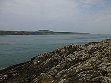 Image © A. Brookes (26.7.2014)

