The Modern Antiquarian
Log in
|
Register
Home
Latest Posts
Forums
Maps
Help
Browse Sites
News
Blog
Contributors
The Books
Select
-
Belgium
Denmark
Eire
France
Germany
Greece
Italy
The Netherlands
Norway
Portugal
Republic of Malta
Spain
Sweden
Switzerland
United Kingdom
County Cork
Garranes North
Standing Stone / Menhir
Garranes North (Standing Stone / Menhir) on The Modern Antiquarian, the UK & Ireland's most popular megalithic community website. 5 images, 1 fieldnote, plus information on many more ancient sites nearby and across the UK & Ireland.
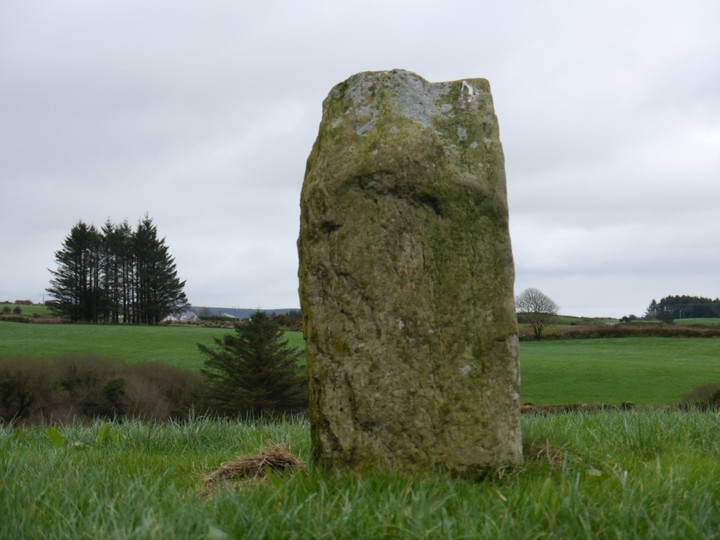
Image © Michael Mitchell
Nearest Town:
Drimoleague (4km SSE)
OS Ref (IE):
W124498 /
Sheets: 85, 89
Latitude:
51° 41' 38.25" N
Longitude:
9° 16' 1.36" W
Added by
Meic
Images (5)
Fieldnotes (1)
0 discussions
Start a topic
Show |
Hide
Web searches for Garranes North
Flickr
Google
Google Images
The Megalithic Portal
Bing
Stone Pages
Wikipedia
Show map
(inline Google Map)
- Sites within 20 km -
-
Clodagh (2.79km ENE) (19 posts)
Clodagh Row (3km ENE) (12 posts)
Shronacarton (3.32km ESE) (6 posts)
Cullenagh (3.41km NE) (11 posts)
Goulacullin (4.12km N) (4 posts)
Cullenagh (4.55km NE) (9 posts)
Toughraheen (4.57km WSW) (1 post)
Baurnahulla (4.98km SE) (3 posts)
Gortnacowly (5.75km WNW) (15 posts)
Barnagowlane West (6.12km NW) (9 posts)
Gortnascreeny (6.46km WSW) (5 posts)
Farnanes (6.69km NE) (9 posts)
Maughanaclea NE (6.89km NW) (9 posts)
Cousane (6.89km NNW) (4 posts)
Ardrah (7km WNW) (20 posts)
Cousane (7.08km NNW) (10 posts)
Glanbannoo Upper (7.08km W) (7 posts)
Cloonygorman (7.11km W) (3 posts)
Glanbannoo Upper (7.21km W) (3 posts)
Maughanaclea Centre (7.37km NW) (7 posts)
Dromore School (7.66km WSW) (3 posts)
Derryarkane (8.16km W) (0 posts)
Cahermuckee (8.41km NW) (5 posts)
Trawlebane (8.41km WSW) (15 posts)
Trawlebane 1 (8.46km WSW) (7 posts)
Inchybegga (8.51km WSW) (2 posts)
Derrynacaheragh (8.69km NE) (2 posts)
Lissangle (8.74km S) (5 posts)
Kealkil (8.92km WNW) (45 posts)
Breeny More (9.13km WNW) (30 posts)
Inchireagh (9.31km NE) (11 posts)
Trawlebane 2 (9.54km WSW) (5 posts)
Cappanaboul (9.59km W) (7 posts)
Reavouler (9.78km ESE) (14 posts)
Cullomane East (9.81km WSW) (4 posts)
Cullomane (9.85km WSW) (10 posts)
Cullomane East (9.9km WSW) (3 posts)
Shandrum Beg (9.9km W) (5 posts)
Cullomane East (10.03km WSW) (6 posts)
Cullomane East (10.03km WSW) (3 posts)
Cullomane East (10.03km WSW) (7 posts)
Derrynasafagh (10.27km ENE) (3 posts)
Baurgorm (10.47km WSW) (11 posts)
Cappaboy Beg (10.78km NW) (2 posts)
Cappaboy Beg (10.81km NW) (4 posts)
Cappaboy Beg (10.83km NW) (3 posts)
Cappaboy Beg (10.83km NW) (2 posts)
Garryglass (10.85km E) (3 posts)
Garrygalss (10.88km E) (0 posts)
Cappaboy Beg SE (10.92km NW) (7 posts)
Dunmanway North (10.94km ENE) (5 posts)
Bawnishall (11.33km S) (3 posts)
Cullomane West (11.35km WSW) (10 posts)
Knocknaveagh (11.41km WSW) (4 posts)
Baurgorm SW (11.47km WSW) (1 post)
Dromourneen (11.49km SW) (2 posts)
Maughsilly (11.8km WNW) (1 post)
Maughanasilly (11.86km WNW) (23 posts)
Caherogullane (12.17km WSW) (5 posts)
Derreengreanagh (12.19km WSW) (11 posts)
Cappaboy Beg NW (12.23km NW) (6 posts)
Killinga (12.38km ESE) (6 posts)
Illane (12.42km WNW) (7 posts)
Scartbaun (12.54km WSW) (5 posts)
Scartbaun (12.77km WSW) (1 post)
Dooneens (12.79km N) (4 posts)
Coolmountain (12.91km NNE) (7 posts)
Ballyhalwick (12.96km ENE) (3 posts)
Gurteenaduige (13.41km ESE) (8 posts)
Dooneens (13.47km NNW) (9 posts)
Nedinagh West (13.48km ENE) (3 posts)
Parkana (13.83km WSW) (3 posts)
Keilnascarta NW (13.83km WSW) (6 posts)
Keilnascarta (13.87km WSW) (5 posts)
Keilnascarta SE (13.9km WSW) (5 posts)
Coolnagarrane (14.08km SSE) (2 posts)
Farrannahineeny (14.1km NE) (16 posts)
Skeagh (14.26km SSW) (3 posts)
Cloghboola (14.32km S) (5 posts)
Cappaghmore (14.41km SW) (6 posts)
Lettergorman (North) (14.46km E) (25 posts)
Ballyroe (14.48km ESE) (8 posts)
Carrigagrenane SW (14.53km E) (9 posts)
Maulinward (14.54km WSW) (6 posts)
Maulinward (14.54km WSW) (6 posts)
Derrynafinchin (14.6km WNW) (16 posts)
Maulatanvally (14.6km E) (8 posts)
Inchincurka (14.69km NE) (15 posts)
Tullig Stone (14.72km ESE) (3 posts)
Carrigagrenane NE (14.78km E) (7 posts)
Derrynafinchin (14.78km WNW) (1 post)
Abbeystrowry (14.9km S) (5 posts)
Maulatanavally (14.96km E) (26 posts)
Mill Little (14.98km W) (28 posts)
Knockawaddra W (15.07km E) (17 posts)
Lyre (15.24km SSW) (6 posts)
Knockawaddra E (15.26km E) (15 posts)
Ballybane (The Rock of the Rings) (15.31km SW) (4 posts)
Milleennagun (15.43km E) (12 posts)
Ballybane West NW (15.45km SW) (5 posts)
Milleennagun (15.53km E) (3 posts)
Lissaclarig West (15.53km SSW) (7 posts)
Beach (15.58km WSW) (1 post)
Glanbrack (15.66km E) (15 posts)
Western Pap (15.68km NNW) (9 posts)
Foherlagh (15.69km SSW) (8 posts)
Ballycommane (15.99km WSW) (3 posts)
Ballycommane (15.99km WSW) (2 posts)
Murrahin North (16.14km SW) (8 posts)
Murrahin North (16.31km SW) (13 posts)
Dromclogh (16.51km WSW) (5 posts)
Reanascreena (16.57km E) (46 posts)
Behagullane (16.65km ENE) (1 post)
Gortafludig (16.66km NNW) (0 posts)
Borlin Valley Standing Stone (16.88km NW) (7 posts)
Toom (16.95km ENE) (4 posts)
Currahy (17.2km N) (4 posts)
Inchinattin (17.44km E) (2 posts)
Sarue (17.46km E) (7 posts)
Hollyhill (17.7km SSW) (5 posts)
Keamcorravooly (17.92km N) (11 posts)
Knocks N (17.95km E) (20 posts)
An Screathan Mór (17.98km NNW) (3 posts)
Turnaspidogy (17.98km NNE) (8 posts)
Keamcorravooly (18.02km N) (4 posts)
Knocks (18.03km E) (2 posts)
Killacoosane (18.25km ESE) (6 posts)
Coolnaconarty (18.5km E) (9 posts)
Knocks S (18.56km E) (18 posts)
Knocks (18.59km E) (13 posts)
Rooska East (18.61km WSW) (6 posts)
Caherkirky (18.81km E) (11 posts)
Freahanes (18.87km E) (7 posts)
Inchinanagh (18.88km NW) (6 posts)
Gurranes (18.97km SE) (25 posts)
Drombeg (19.05km ESE) (70 posts)
Kinneigh (19.35km ENE) (5 posts)
Knockdrum (19.37km SE) (12 posts)
Gorteennakilla (19.57km N) (6 posts)
Coolcoulaghta (19.59km WSW) (5 posts)
Lettergorman (South) (19.6km ESE) (39 posts)
Inishbeg (19.84km SSW) (5 posts)
Carrigillihy (19.93km SE) (9 posts)
Carrigillihy (19.93km SE) (6 posts)
Knockanereagh (20km NE) (8 posts)
- Add -
-
Add news
Add an image
Add fieldnotes
Add folklore
Add miscellaneous
Add a link
-
Add a site
Add a nearby facility
Add an alternative name/spelling
Images
(click to view fullsize)
Add an image
Fieldnotes
Add fieldnotes
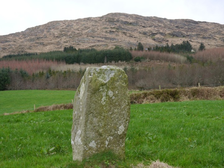
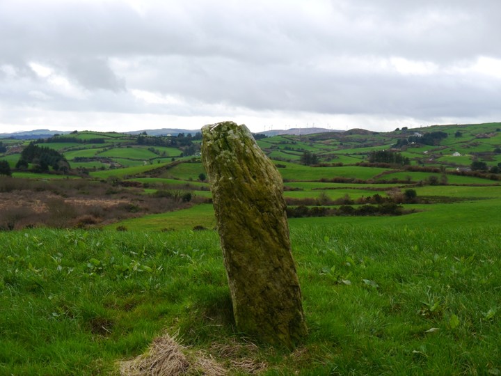
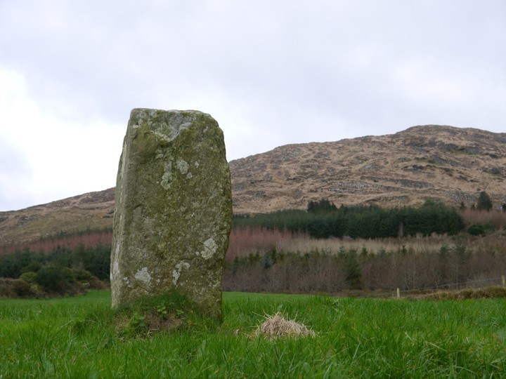
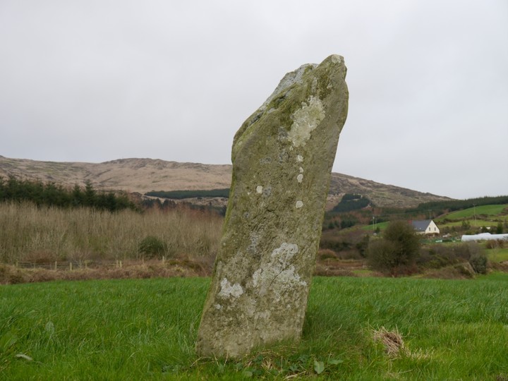
About a mile East of Castle Donovan along a pot hole filled minor road. It is marked on the OS map.
Situated on a small hillock, with extensive views in all directions.
Comments (0)
|
Add a comment
|
Permalink
Posted by
Meic
14th February 2012ce

 Posted by Meic