The Modern Antiquarian
Log in
|
Register
Home
Latest Posts
Forums
Maps
Help
Browse Sites
News
Blog
Contributors
The Books
Select
-
Belgium
Denmark
Eire
France
Germany
Greece
Italy
The Netherlands
Norway
Portugal
Republic of Malta
Spain
Sweden
Switzerland
United Kingdom
Scotland
Aberdeenshire
Burryhillock
Cup Marked Stone
Burryhillock (Cup Marked Stone) on The Modern Antiquarian, the UK & Ireland's most popular megalithic community website. 4 images, 1 fieldnote, plus information on many more ancient sites nearby and across the UK & Ireland.
Image © drew/amj
Nearest Town:
Inverurie (14km E)
OS Ref (GB):
NJ6398526209 /
Sheet: 37
Latitude:
57° 19' 30.19" N
Longitude:
2° 35' 53.33" W
Added by
drewbhoy
Images (4)
Fieldnotes (1)
0 discussions
Start a topic
Show |
Hide
Web searches for Burryhillock
Flickr
Google
Google Images
MAGIC
The Megalithic Portal
Bing
Stone Pages
Streetmap.co.uk
Wikipedia
Show map
(inline Google Map)
- Sites within 20 km -
-
Cobrigdale Hill (1.5km ESE) (5 posts)
Tillymuick (1.96km ESE) (8 posts)
Hatton of Ardoyne (2km ENE) (17 posts)
Westerton Of Petmathen (2.47km ENE) (11 posts)
Wantonwells (2.48km W) (26 posts)
Brownhills 2 (near Ardoyne) (2.6km NE) (3 posts)
Brownhills (near Ardoyne) (2.68km NE) (5 posts)
Berryhill (2.84km E) (6 posts)
Berryhill (2.97km E) (9 posts)
South Lediken (3.12km NNE) (4 posts)
Pitmachie (3.2km NE) (4 posts)
Dunnydeer (3.34km WNW) (6 posts)
Dunnideer (3.41km W) (31 posts)
Inschfield (3.56km NW) (12 posts)
The Good Man's Fauld (3.69km WSW) (2 posts)
Gowk Stane, Oyne (3.74km E) (8 posts)
Dunnydeer Farm (3.83km W) (21 posts)
Hawk Hill (3.96km WSW) (9 posts)
Hill Of Christ's Kirk (3.98km W) (14 posts)
Little Oxen Craig (4.11km ESE) (6 posts)
Kirkton Of Oyne (4.13km E) (9 posts)
Newton Stone (4.16km NE) (12 posts)
Bennachie (4.22km ESE) (43 posts)
Oxen Craig (4.24km ESE) (32 posts)
Socket Stone Rock (4.28km ESE) (4 posts)
Oxen Craig Peak 2 (4.29km ESE) (2 posts)
Oxen Craig South Western Descent (4.3km ESE) (16 posts)
Old Rayne (4.38km ENE) (35 posts)
Stonehead (4.52km W) (34 posts)
Druidstones (4.62km SW) (20 posts)
Braehead (4.82km WSW) (14 posts)
Mellenside (5.16km NNE) (8 posts)
Fallow Hill (5.28km NNW) (5 posts)
Mill of Carden (5.3km E) (11 posts)
Candle Hill (5.49km WNW) (35 posts)
Newlands Of Oyne (5.55km E) (2 posts)
Hill Of New Leslie (5.62km WSW) (5 posts)
Pittodrie Quarry (5.65km E) (5 posts)
Maiden Castle (Pittrodie) (5.72km E) (20 posts)
Mither Tap (5.73km ESE) (73 posts)
Satter Hill (5.76km SW) (8 posts)
Culsalmond (5.78km NNW) (4 posts)
Colpy (5.86km NNW) (2 posts)
The Ringing Stone (6.16km WSW) (6 posts)
Hill Of Knockollochie (6.31km E) (5 posts)
The Law (6.35km ENE) (14 posts)
Knock Saul (6.78km WSW) (7 posts)
Bowman Stone (6.79km ENE) (4 posts)
Cothiemuir Wood (6.79km SSW) (78 posts)
Bowman Stone 2 (6.79km ENE) (4 posts)
Mummer's Reive (6.81km NNE) (6 posts)
Gouk Stane, Bennachie (6.95km ESE) (5 posts)
Fallow Cairn (7.12km W) (4 posts)
Fallow Hill (7.13km W) (6 posts)
Lenchie (7.27km WNW) (4 posts)
The Barmkyn (7.38km SW) (19 posts)
Newton Of Wardhouse Farm (7.4km W) (3 posts)
Hill Of Airlie (7.42km SW) (7 posts)
Newton Of Wardhouse (7.7km W) (8 posts)
Millstone Hill East (7.71km ESE) (10 posts)
North Rayne (7.71km NE) (4 posts)
Durno (7.83km ENE) (4 posts)
Wardhouse (8.01km W) (5 posts)
Backley Hill 1 (8.02km ENE) (8 posts)
Old Keig (8.03km SW) (48 posts)
Backley Hill (8.08km ENE) (5 posts)
Millstone Hill East 2 (8.08km ESE) (8 posts)
Backley Hill 2 (8.13km ENE) (7 posts)
Hill Of Whitecross (8.47km E) (9 posts)
Pitscurry (8.62km ENE) (8 posts)
Ardlair (8.82km W) (35 posts)
Hill Of Rothmaise (8.83km NE) (7 posts)
Broadsea Farm (8.83km E) (6 posts)
Tofthills (8.86km W) (9 posts)
The Tow Stone (9.26km NE) (5 posts)
Crookmore (9.35km SW) (2 posts)
East Blairbowie (9.58km E) (8 posts)
Balquhain (9.69km E) (34 posts)
The Ark Stone (9.69km ESE) (4 posts)
Chapel O'Sink (9.83km ESE) (8 posts)
Leggetsden (10.09km E) (4 posts)
Corrie (10.44km WSW) (10 posts)
Druidsfield (10.52km SW) (17 posts)
Baldyvin (10.57km SSW) (4 posts)
Leith Hall Policies (10.59km W) (9 posts)
Liggars' Stane (10.63km E) (7 posts)
Easter Aquhorthies (10.65km E) (135 posts)
Scotsmill (10.79km SW) (6 posts)
Drimmies (10.97km E) (5 posts)
Loanhead of Daviot (10.98km ENE) (104 posts)
New Craig (11.04km ENE) (20 posts)
New Craig (11.05km ENE) (12 posts)
Altar Stone, Hillhead (11.06km W) (2 posts)
Clatt Bankhead (11.07km W) (6 posts)
Clatt Hillhead (11.15km W) (5 posts)
Middleton (11.15km E) (3 posts)
Luath's Stone (11.19km SSE) (23 posts)
White Hill (11.26km WSW) (6 posts)
The Candy Stone (11.4km W) (5 posts)
Deer Park (11.47km SE) (25 posts)
Dilly Hill 2 (11.5km E) (4 posts)
Dilly Hill 3 (11.58km E) (4 posts)
Dilly Hill (11.6km E) (4 posts)
Dilly Hill Cairn (11.69km E) (4 posts)
Conglas (11.8km E) (5 posts)
Conglas 2 (11.84km E) (6 posts)
Lumphart Hill (11.86km ENE) (7 posts)
Auchencleith (11.86km ENE) (6 posts)
Balhalgardy (12.02km E) (5 posts)
Smallburn (12.16km WSW) (6 posts)
Auld Kirk Of Alford (12.38km SW) (11 posts)
Stonyfield (12.45km NW) (13 posts)
Tombeg (12.51km SE) (8 posts)
Brandsbutt (12.59km E) (20 posts)
Nether Coullie (12.63km ESE) (8 posts)
Whitehills (12.69km SSE) (50 posts)
Corrstones (12.97km W) (27 posts)
Drumel Stone (13km W) (3 posts)
Gallow Hill (13.01km SW) (9 posts)
Logie Newton (13.01km N) (8 posts)
Nether Balfour (13.48km SW) (2 posts)
North Strone (13.58km SSW) (17 posts)
Cairn More (13.64km WSW) (4 posts)
Upper Third (13.67km NNE) (18 posts)
Mill of Noth (13.73km W) (10 posts)
Rhynie Graveyard (13.94km W) (7 posts)
Wolf Stone (13.94km SSE) (10 posts)
Langstane o' Craigearn (14km ESE) (13 posts)
Rhynie Standing Stones (14.08km W) (9 posts)
Lord Arthur's Hill (14.09km WSW) (14 posts)
Auchaber (14.12km NNW) (5 posts)
Bell Knowe (14.15km W) (6 posts)
Barflats (Rhynie) (14.19km WSW) (7 posts)
Deil's Stane (14.29km ESE) (8 posts)
Findlatree (14.31km SSW) (5 posts)
Cuning Hill (14.35km E) (8 posts)
Damil (14.48km SW) (5 posts)
Woodend of Cluny (14.62km ESE) (8 posts)
Bruce's Camp (14.7km E) (7 posts)
Fullerton/Bogcoup (14.9km NNW) (3 posts)
Balcairn (15.09km ENE) (3 posts)
Hawk Law (15.14km E) (5 posts)
Hillhead Of Barra (15.18km E) (7 posts)
Newseat 2 (15.22km W) (4 posts)
Newseat (15.23km W) (9 posts)
Clovenstone Farm (15.25km E) (5 posts)
Camies Stone (15.26km E) (6 posts)
Broomend of Crichie (15.31km E) (69 posts)
Carnaveron (15.33km SW) (4 posts)
Broomend (15.42km E) (6 posts)
Newtongarry Hill (15.44km NW) (7 posts)
Broomend 2 (15.48km E) (5 posts)
Broomend Cist(s) (15.55km E) (7 posts)
Ord Hill (15.58km W) (8 posts)
Balgorkar (15.6km ESE) (40 posts)
John Bells Stone (15.72km ESE) (3 posts)
Upper Ord (15.74km W) (13 posts)
Clochmaloo (15.78km W) (5 posts)
Tap o' Noth (15.83km W) (73 posts)
Rumfold (15.93km W) (3 posts)
Wheedlemont (15.98km W) (16 posts)
Bruce's Seat (16.06km ENE) (4 posts)
Giant's Stone (16.07km W) (12 posts)
Hill Of Selbie (16.1km E) (8 posts)
Kirkton of Bourtie (16.12km E) (56 posts)
Little Hillbrae (16.13km E) (6 posts)
Wallace Stone (16.16km E) (3 posts)
Hill of Barra (16.16km E) (30 posts)
Red Hill (16.32km S) (4 posts)
Bellman's Stone (16.39km E) (5 posts)
Braeneil (16.53km ESE) (3 posts)
Cairnhall (16.54km E) (15 posts)
Craigievar (16.56km SSW) (11 posts)
Piper's Stone (16.56km E) (6 posts)
Wheedlemont (16.63km WSW) (13 posts)
Brawland (16.64km W) (5 posts)
The Peirk (16.76km W) (8 posts)
Battle Hill (16.78km WNW) (8 posts)
Frendraught (16.83km NNW) (13 posts)
Burreldales (16.94km NE) (5 posts)
Auld Kirk O' Tough (17.04km S) (11 posts)
Drumfours (17.09km SSW) (7 posts)
Cairnhill (17.15km SSW) (2 posts)
South Balnoon (17.29km N) (6 posts)
Mains of Hatton (17.3km NNE) (16 posts)
Newells (17.3km ENE) (6 posts)
Huntly (17.37km WNW) (9 posts)
Lumphanan Hill (17.46km ESE) (5 posts)
Raich (17.5km NNW) (22 posts)
The Knock (17.63km ESE) (4 posts)
Harestane, Feith Hill (17.72km N) (6 posts)
Pitglassie (17.77km NNE) (14 posts)
Nether Lauchentilly (17.84km ESE) (5 posts)
Cairn Of Pitmansy (17.86km NE) (11 posts)
South Leylodge (18km ESE) (20 posts)
Clashmach (18.01km WNW) (10 posts)
Leylodge School (18.1km ESE) (4 posts)
Shieldon (18.29km E) (59 posts)
Stoneyhill (18.29km E) (4 posts)
South Leylodge (18.36km ESE) (4 posts)
Midtown Of Pitglassie (18.36km NNE) (8 posts)
Lulach's Stone (18.42km WSW) (11 posts)
Corsindae (18.47km SE) (4 posts)
Kirk Wood (Leochel) (18.49km SW) (7 posts)
Leylodge School 2 (18.5km ESE) (4 posts)
The Grinago Stone (18.5km ENE) (10 posts)
Tomnagorn (18.51km SSE) (29 posts)
Old Kinnernie (18.52km SE) (6 posts)
Midtown Of Pitglassie 2 (18.55km NNE) (4 posts)
Corsindae (18.57km SE) (6 posts)
Hill Of Old Merdrum (18.61km W) (3 posts)
Corsindae (18.61km SE) (4 posts)
Kintore Golf Club (18.64km E) (8 posts)
Clashmach Hill (18.72km WNW) (9 posts)
Kildrummy Kirk (18.74km WSW) (4 posts)
Hill of Old Merdrum (18.79km W) (3 posts)
Leochel-Cushnie (18.93km SW) (5 posts)
Hill of Tuack (18.96km E) (14 posts)
Clova 1 (19.01km WSW) (14 posts)
Midmill (19.02km E) (11 posts)
Clova 2 (19.11km WSW) (18 posts)
Waterside (19.13km E) (9 posts)
Greenlands (19.13km E) (6 posts)
Finglenny (19.19km W) (11 posts)
Cairnton (19.19km NW) (10 posts)
Whitehillock (19.23km WSW) (6 posts)
Mill Of Brux (19.28km WSW) (4 posts)
Peat Hill (19.35km E) (4 posts)
Cairncoullie (19.36km SW) (4 posts)
Peat Hill (19.43km E) (8 posts)
Clashholm (19.43km S) (10 posts)
Corrydown (19.45km NNE) (16 posts)
Wormy Hillock (19.46km W) (16 posts)
Newton Of Fortrie (19.57km N) (4 posts)
Roddantree (19.62km WNW) (12 posts)
Hillhead Of Suttie (19.78km E) (7 posts)
Allrick Hill (19.79km WNW) (8 posts)
Nether Corskie (19.83km ESE) (11 posts)
Wester Clova (19.89km WSW) (3 posts)
Ferneybrae (19.9km E) (5 posts)
Yonder Bognie (19.94km NNW) (19 posts)
Hill Of Boghead (19.97km E) (7 posts)
- Facilities within 20 km -
-
Bridge of Muchalls (Bed & Breakfast: 14.9 km SE)
- Add -
-
Add news
Add an image
Add fieldnotes
Add folklore
Add miscellaneous
Add a link
-
Add a site
Add a nearby facility
Add an alternative name/spelling
Images
(click to view fullsize)
Add an image
Fieldnotes
Add fieldnotes
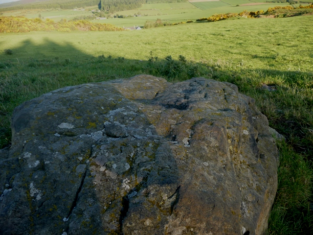
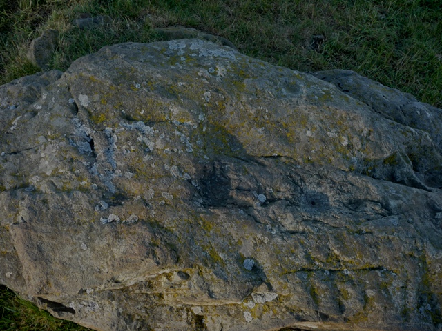
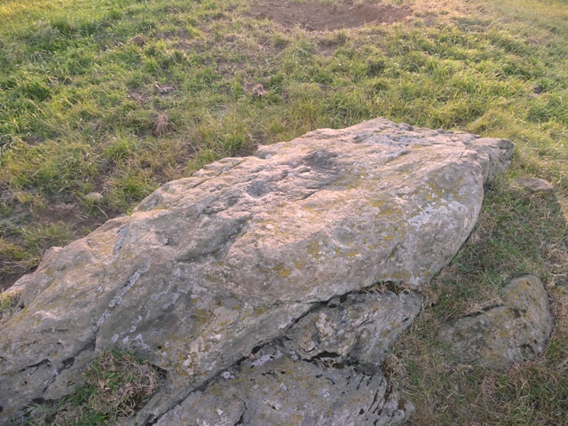
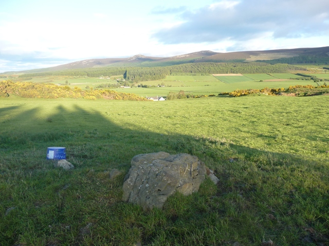
A new find with 5 cup marks 1 west side, 1 east side, and 3 down the middle. Possibly there are 2 well weathered efforts as well. Plenty of rocks and plates on the surrounding hills Mr T.
Visited 29/5/2011.
Comments (3)
|
Add a comment
|
Permalink
Posted by
drewbhoy
29th May 2011ce