


Btw, Bateman was somehow mistaken, the passage beneath the rocking stone is nowhere near big enough to pass animals through, yeah at the front of the stone there’s a rather large opening but it narrows down to almost nothing at the back, no way could you safely pass a baby through unless you had octopuss arms and a couldn’t care less attitude to your young uns.
Ok prod a piglet with a pointy stick and it would make it through i admit but it’s not practical to do so on any scale.
My Jack Russel could do it at a squeeze if i stood the other side with a nice bit of meat to temp her.
: )
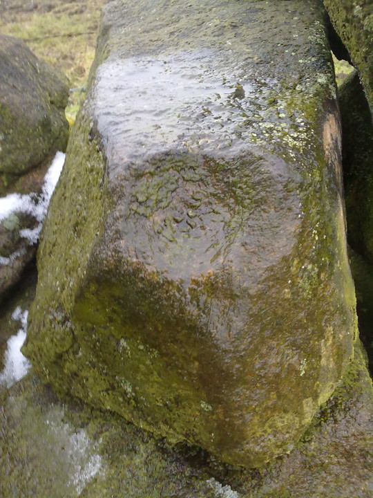
Found another “cup mark” after searching the tor for a good few hours.
I credit it to Thomas Eyre along with the other carvings i found. ; )

Imo all the markings are natural, for what it’s worth.
Sorry.


A stone similar in size to the Avebury stones that lays on top of of the earth to the side of the sarsen drift at the bottom of a natural ramp leading up to the high point of the down in the direction of Avebury.
It’s said it may have been destined for Avebury but never made it for some reason.
For me it’s a stone of significance due to it’s size, location and the story attached to it, it’s also the largest surviving (non buried) stone in that area, though a few lumps have been knocked off it.
Follow the Herepath up to the ridgeway, enter Fyfield down via the gate then carry on till you cross the gallops, follow the path into the valley then turn right following the course or the sarsen drift, to the right of the drift you’ll easily spot the Monster stone, to me it looks rather like a giant frog, well from a distance anyway.

Sunset over Silbury from west Kennet long barrow, solstice 2010.


stones in the moat, no one ever mentions these, thanks Peteg for pointing them out.


Polisher mark on second chamber to the left.


Video of Bradley tor rocking stone:
pecsaetan.weebly.com/bradley-tor-rocking-stone.html

The central cup and ring of the three on the angular boulder.

Cup with worn ring.
This one is often overlooked but well worth a gander.


Located within the grounds of Saint Mary’s church in the tiny village of Bolsterstone, the two stones lay recumbent, one on top of the other and are said to be the base of two Saxon crosses now long gone, sockets are still visible in the uppermost stone.
The stones once stood in the centre of the village probably on the village green and are thought to have been moved to their current position in the 19th century for safekeeping.
The stones are just inside the church yard through the lych gate, the main entrance, and can be viewed at any time.


Parsonage farm trail.
Described as late neolithic or early bronze age here.
Described as the burial place of king Walder here and dated as Saxon.

The wall of robbed material running from bottom left of the pic and all way down the field, the wall that runs off to the left across the next field is also largely robbed material too.


What an intriguing place.
The cairn is located within a walled field, 3 of the field walls are constructed from modern style dry walling whilst the other which runs around a hundred metres is built from material robbed from the cairn, there must be 10, 15, 20 tons of it which would have made the cairn quite a sight before it was robbed.
Today the megalith and the few rocks that are holding it in place are an eyesore, the reconstruction was done with concrete it seems, very ugly and unsympathetic.
Great site not far from parking in bolsterstone village, a must see if your anywhere nearby.
Another possible cup marked stone close by the circle.

Slightly different angle of Ciceley Low 2 from Stu’s.

What a strange strange place, i can’t make head nor tail of this jumble of boulder.
I spent over an hour wandering around scratching my head, hmmming and arrring.
I’m no ancient fort expert, which would have been evident had you been there with me, still scratching my head now.
Great place for a fort though, if that’s what it was.
*Scratches head some more*


Winter solstice 09
Mistletoe and fruit offerings. (not mine)
From Redmires Road, follow the path on the opposite side of the road from the reservoirs that follows the “conduit”: a man-made drainage ditch that empties into the upper reservoir and marked on the map at SK 26018578. You’ll need to follow this for about 1km till you come to a junction with a path crossing a small bridge on your left, and a path to your right onto the moor. You need to take the latter for about 200 metres downhill. The standing stone is roughly 100 metres onto the moor in a NNE direction.
Standing around 1.2 metres high, surrounded by mature heather and aligned roughly North / South I noticed this particular stone one day whilst making my way back from the Reddicar Clough / Ash Cabin Cist and heading towards the Headstone (.5km NNW), there’s no history i know of as i can’t find reference to it anywhere but the weathering on it’s top certainly suggests it’s been stood for a very long period and probably back in to prehistory.

The standing stone with teenage guardians for scale.. : )

Cup mark. ?
Not on the rocking stone but lower down on the other end of the tor.
From Nine stones Close circle and with your back to Robin Hoods stride walk downhill to the right hand corner of the field and go through the gateway, turn left and follow the wall to the gateway half way along and go through it, turn right and walk around 10 metres down the wall and the cup stone is on top of it.
I’ve never heard mention of this stone anywhere before, if you know different could you post the info please.


