
Looking into chamber 2 showing the height of the entrance passage
Image credit: Chance - Sep 2008

Looking into chamber 2 showing the height of the entrance passage

View of the dry stone walling and stone facades in chamber 1


View from the passage looking out from the entrance to chamber 1

View from the passage leading into chamber 1

Location Plan for Tumulus du Montioux

Information board for Tumulus du Montioux

Pierre du Sacrifice – Capstone of the destroyed tumulus in the Forêt-de-Boixe

Pierre du Sacrifice – Capstone of the destroyed tumulus

Pierre du Sacrifice – Capstone of the destroyed tumulus
Notes from the proceedings of the Society of Antiquaries of Scotland from December 11 1922
on Raedykes northern Stone Circle and the inner Stone Setting, together with the Ogam inscription which is incised on its southern side.

Plans of individual Stone Circles at Raedykes.

The southern side of Stone No. 4 with it’s yoni symbolism of strange tiny rings and U-shapes.

The sign says it all.
A 4 mile walk to the nearest camp site.

A view of Stonehenge from the top deck of the old No.3 bus service as it pulls into the car park.

Why did they build Stonehenge so close to the road?
The A344 from Stonehenge bottom to Shrewton goes straight pass the Heel Stone, but is no older than the turnpiking of the roads of the 1760s.
The closest milestone, facing the Heel Stone, reads “LXXX (80) miles from London, II (2) miles from Amesbury”

The final acts of Druidic ritual are carried out while people slowly drift away from Stonehenge.
Once again, Spring equinox 2008 passes off peacefully with no trouble, respectful observers and happy helpers.

In the 18th century the hillfort became part of the landscaped gardens of the Marquess of Queensberry’s house at Amesbury Abbey, later known as the Antrobus Estate. This new phase included landscaping with tree planting, ornamental walks, vistas and a grotto.
Today, trees and shrubs cover Vespasian’s Camp. This legacy from the garden phase of its history is now a listed Grade II park and garden.
Grim’s Ditch (Dyke) East and West Hendred SU: 423845 to 542833
Field Notes – 25-08-07
Ordnance Survey Explorer Map 170 – Scale 1:25000
Abingdon,Wantage and the Vale of the White Horse
ISBN 978-0-319-23611-6
Although this earthwork was probably once more or less continuous, it is now broken into a number of sections, largely as a result of agriculture. Its antiquity is demonstrated by the fact that a number of parish boundaries run along it. Its date is not known, but such earthworks are generally considered to be of the iron age, often defining boundaries rather than defences. The greatest height of the earthwork from the crest of the bank to the ditch bottom is 1.8 m.
The pictures posted here are from the section at the bottom of the Lord Wantage monument at SU 423845.

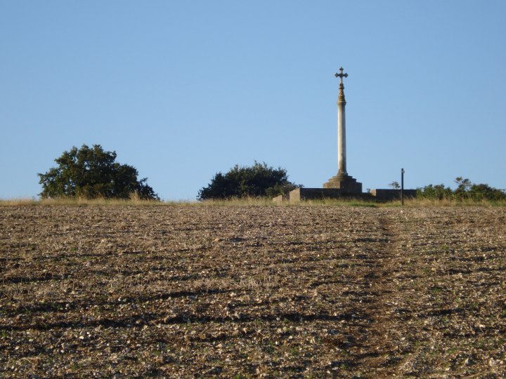


The view showing the track leading up to Lambourn Long Barrow. – This point marks the county line between Oxfordshire and Berkshire.

View of a bowl barrow from the L7B group and riding rail.

The view from the road leading into Lambourn. – This is the most westerly point of the barrow group and the closest to the original long barrow (known to be visible). This point also marks the county line between Oxfordshire and Berkshire. A strange border that is difficult to follow on the OS map, this looks like it was re-drawn many times in the ancient past, with the L7B barrow group and it’s outlining barrows, defining the territory of one tribe to that of another.

The Lambourn Seven barrows – View from the ancient track that runs beside the group.
Although there are some forty barrows in the vicinity altogether, only those in this enclosure beside the road may be visited without permission.
The barrows in this view use the numbering by L. V. Grinsell and Humphrey Case.
From left to right, No.8, two barrows enclosed within a single ditch, their mounds overlapping, suggesting that one is earlier than the other. To the right are No.6, a large bowl-barrow with No.7, a tiny barrow on its south side.
Next to this is No.5 a bowl-barrow 21m in diameter and 1.8m high, while behind is No.11 another bowl-barrow 3m high and 30m in diameter. Its contents are unknown.
The furthest barrow is No.10, which is another two barrows enclosed by a single ditch. A hollow on top of the north mound was made by Martin Atkins about 1850. He found the bones of an ox and a dog.

View of the western edge of the L7B group. The long barrow lies at the base of the trees on the left of the picture.
It may sound amazing that a barrow 220ft long and 50ft wide should have passed unnoticed, but one end of it was ploughed up, and this cart-track and grassy bank runs across the other end.

The cart track and grassy bank that runs over the southern end of the long barrow. The sarsen stones which originally formed the passage and chambers lay beneath this cart-track and had become exposed. This is what drew Mr L V Grinsell’s attention to the long barrow in 1935.

One of the sarsens from the burial chamber churned up and discarded.

The southern end of the long barrow with the recent fence running across the ancient monument

Looking out into the vale of the white horse

Dragon Hill as seen from the Uffington White Horse

Dragon Hill as seen from the road leading up to to the Uffington White Horse

Dragon Hill as seen from the road leading up to to the Uffington White Horse

The Uffington White Horse looking into the manger

The Uffington White Horse as seen from Dragon Hill

The Wansdyke on Tan Hill looking south

The Cove from the car park of the Red Lion.
Kodak Black and White Infra Red with R25 red filter. Rated at 1600 ASA dev in D76 for 10 mins at 20 degress Centigrade
History of Handfasting or hand-festa
Their are two theories as to the origins of this term;-
a) Originally a loan from Old Norse hand-festa “to strike a bargain by joining hands”.
b) “Handfasting” was the word used by the ancient Celts to describe their traditional trial-marriage ceremony, during which couples were literally bound together. The handfasting was a temporary agreement, that expired after a year and a day. However, it could be made permanent after that time, or continued for another year and a day, if both spouses agreed.
Either way, handfasting was suppressed following the Synod of Whitby in 664, when Celtic Christianity was abandoned for the Catholic Church. At The Council of Trent, 1545-1563, Roman Catholic marriage laws were changed in order for any marriage to require the presence of a priest.
This change did not extend to the regions affected by the Protestant Reformation, and in Scotland, marriage by consent remained in effect.
By the 18th century, the Kirk of Scotland no longer recognized marriages formed by mutual consent and subsequent sexual intercourse, even though the Scottish civil authorities did. This situation persisted until 1940, when Scottish marriage laws were reformed.
In the 18th century, well after the term handfasting had passed out of usage, there arose a popular myth that it referred to a sort of “trial marriage”. A.E. Anton, in Handfasting’ in Scotland (1958) finds that the first reference to such a “trial marriage” is by Thomas Pennant in his 1790 Tour in Scotland. This report had been taken at face value throughout the 19th century, and was perpetuated.
In 1820, Sir Walter Scott used the term to refer to a fictional sacred ritual that bound the couple in a form of temporary marriage for a year and a day. He wrote of it in his book “The Monastery:”
“When we are handfasted, as we term it, we are man and wife for a year and a day; that space gone by, each may choose another mate, or, at their pleasure, may call the priest to marry them for life; and this we call handfasting.”
During the 1995 movie, Braveheart, Mel Gibson, in the role of William Wallace, was handfasted with his girlfriend Murron. Handfasting has since grown in popularity among Cowans (non-Pagans), particularly those whose distant ancestors lived in ancient Celtic lands.
Modern usage, A Neopagan handfasting
In the present day, some Neopagans practice this ritual. The marriage vows taken may be for “a year and a day”, a lifetime, “for all of eternity” or “for as long as love shall last”, sometimes called “till the end of love”. Whether the ceremony is legal, or a private spiritual commitment, is up to the couple. Depending on the state where the handfasting is performed, and whether or not the officiate is a legally recognized minister, the ceremony itself may be legally binding, or couples may choose to make it legal by also having a civil ceremony.
Modern handfastings are performed for heterosexual or homosexual couples, as well as for larger groups in the case of polyamorous relationships. Currently, handfasting is a legal Pagan wedding ceremony in Scotland, but not in England, Wales or Ireland.
In 2000, William Mackie, a bishop of Celtic Church in Scotland, a small faith group that has attempted to recreate Celtic Christianity and promote the legalization of handfasting ceremonies said: “I plan to lobby MSPs to get it reinstated in its entirety: a lot of people make a mistake and, as long as there are no children involved, the one year opt-out would save a lot of hassle.”
As with many Neopagan rituals, some groups may use historically attested forms of the ceremony, striving to be as traditional as possible, while others may use only the basic idea of handfasting and largely create a new ceremony.
As many different traditions of Neopaganism use some variation on the handfasting ceremony, there is no universal ritual form that is followed, and the elements included are generally up to the couple being handfasted. In cases where the couple belong to a specific religious or cultural tradition, there may be a specific form of the ritual used by all or most members of that particular tradition. The couple may conduct the ceremony themselves or may have an officiant perform the ceremony. In some traditions, the couple may jump over a broom at the end of the ceremony. Some may instead leap over a small fire together. Today, some couples opt for a handfasting ceremony in place of, or incorporated into, their public wedding. As summer is the traditional time for handfastings, they are often held outdoors.
A corresponding divorce ceremony called a handparting is sometimes practiced, though this is also a modern innovation. In a wiccan handparting, the couple may jump backwards over the broom before parting hands.
As with more conventional marriage ceremonies, couples often exchange rings during a handfasting, symbolizing their commitment to each other. Many couples choose rings that reflect their spiritual and cultural traditions, while others choose plainer, more conventional wedding rings. These are sometimes referred to as a Claddagh ring. In Oliver Stone’s movie, The Doors, Jim Morrison and one of his girl friends, Patricia Kennealy-Morrison, are seen exchanging marriage vows and rings at a Celtic Pagan handfasting ceremony in June 1970.
I feel this covers the basics of Handfasting, with the principles, beliefs and symbolism.
If approved by the TMA eds, I shall post up some pictures of an actual Handfasting, as carried out on the Ring-Stone.
Chance
The Bath and North East Somerset SMR Listing from 31/3/1999.
Lists various monuments, all scheduled and protected by law

Isometric view of the Roman bath complex and sacred spring of Sulis Minerva.
The top left hand corner contains the temple complex and the source of the sacred hot spring, which feeds the octagonal shaped reservoir. This hot water is then fed into the top left hand corner of the rectangular Great Bath. This was probably the hottest part of the bath and may have been reserved for the most prodigious patrons of the bath house.
Other cold immersion pools line the top edges of the complex, while the sacred hot spring water gradually cools off as it drains to the lower pools before exiting via a culvert in the Abbey courtyard.

The pump room at night.
The flood lit fountain at the far end of the room dates from the height of the Georgian period of Bath’s grandeur. This was built directly above the sacred hot spring and Roman reservoir.
This photo was taken at night through the French windows of the pump room, which open out into the Abbey courtyard. The high Alter lies 20 feet directly below my feet with the temple lying due west under the present pavement and Stall Street.
Field Notes
Amesbury Bowl Barrow – SU 13140 42040 – March 2008
Ordnance Survey Explorer Map 130 – Scale 1:25000
Salisbury & Stonehenge inc. Wilton & Market Lavington.
ISBN 978-0-319-23599-7
Not much to see of Scheduled Monument SM10303, a flattened Bowl barrow. It was almost completely excavated in 1960 by Paul Ashbee, when the A303 was widened for the dual carriageway. A C14 date of 1670 bc +/- 90 was recorded.
When Sir R.C. Hoare first opened it, he recorded finding a primary cremation with shale and amber cones, along with various beads. See, The Ancient History of Wiltshire Vol 1, page 159.
If you take the “permissive path” from the Stonehenge car park, to the New King Barrows you will walk right over it. The path runs parallel to the A344, in the field boundary to Stonehenge Bottom. Gates are provided for access and it is a lot safer than trying to walk along side the road.
For additional information, see SMR Number SU14SW761 at https://history.wiltshire.gov.uk/smr/
Chance

Bowl barrow, what bowl barrow? The road widening has cut away the southern section leaving little to see. Stonehenge and Fargo plantation can be seen in the distance.

View showing the cutting made for the enlarged A303 in 1960. The barrow’s position near Stonehenge would indicate some importance to the resident. A C14 date of 1670 bc +/- 90 has been recorded.

Overall view of the barrow looking towards the A303. This shows how reduced the barrow has become since excavation by Paul Ashbee in 1960.
Field Notes
Barrow Copse Long Barrow, West Woods – April 20th 2008
Ordnance Survey Explorer Map 157 – Scale 1:25000
Marlborough and Savernake Forest Avebury and Devizes
ISBN 978-0-319-23611-6
I first visited this long barrow back in 1988 when we were updating the County’s SMR records. It lies on the edge of a wood or collection of separate pieces of woodland called West Woods. The area was once part of the Savernake Forest, but is now owned by the Forestry Commission.
West Woods is designated access land under the Countryside and Rights of way act 2000. See www.countrysideaccess.go.uk for all the details of these rights.
West Woods is well sign posted and has two car parks, one with a picnic area at SU 16250 66703. This is nearer to the long barrow when you travel up from the A4 and Clatford Bottom. The northern car park at SU 13257 66323, is at the top of the road from Lockerage Dean. If you park here, be prepared for a long, uphill walk into the western side of the wood and along the Wansdyke. This area of the woods has some of the oldest trees, particularly Oaks. When you reach the point that the Wansdyke turns directly into the woods, follow the track to the right and keep to the edge of the wood. The barrow lies just off the track, on the left.
When we visited back in 1988, we came along the track via the byway from Clatford Bottom, which skirts the southern edge of West Woods and the Wansdyke. The barrow seemed to have more oak trees growing over it back then, but little else seems changed. Although it stands on a slight rise, the features of this barrow are difficult to discern, for it is covered both by trees and by a carpet of bluebells.
Both the Ordnance Survey in 1815, (2-inch map) and Colt Hoare in 1821 (map of Marlborough station) depict it as a round barrow. A.C. Smith in 1885 and Goddard in 1913 recorded it as a ‘bowl-shaped’ barrow but it was not until 1923 the A.D. Passmore finally recognized it as a short long barrow, oriented E-W. He gives it dimensions as Length l20 ft, width 66 ft, and 10ft. high. The side ditches, which do not continue round the ends, were then 4ft. deep and 18ft. wide.
The disturbance resulting from the excavation of Sir Henry Meux in about 1880 is still evident; at the top centre of the barrow there is a small depression with a shallow cutting leading from this to the N edge of the mound. A.D. Passmore spoke to Mr. S. Hilliard, the chief woodman, who told him Meux employee six men (of whom he was one) to open the mound.
A trench was cut from the south side into what was thought to be the centre of the tumulus. At this point a small cairn of small sarsen stones was reached. In the centre of this was a dolmen consisting of four upright stones (the spaces between which were packed with large flints) and a capstone covering them, all of sarsen. The large top stone was levered off, as much as the six men could move and the inside was found to contain certain black matter, Mr. Hilliard was unable to say of what nature. He did not see any bones or pottery. The inside of the dolmen was about 6ft. by 3ft., its longer axis coinciding with that of the barrow. As it contained no relics it was left undisturbed, with the capstone replaced in its old position, and the excavation filled in.
When we examined the barrow, it was recorded as 38.0 m long with a maximum width of 30.0 m; being slightly higher at the E end, where it reaches 3.3 m. Well-defined but heavily silted ditches (9.0 m wide, 1.1m deep) flank both sides, and a ditch at the E end (0.5 m deep) is separated from the side-ditches by narrow causeways.
As the barrow has never been properly excavated, further detailed is examination is required to determine whether the central megalithic chamber, perhaps with intact tilling, is the only one within the mound, and whether it ever had a passage allowing repeated access. Side chambers may also have been constructed and lie undisturbed. Passmore muses that although exhibiting features which proclaim it to be a long barrow, this mound may, perhaps, more truly be called an oval mound of a transitional period, the stone chamber in the middle being unusual.

Roughridge Hill Long Barrow^- SU 05486576
The existence of this long barrow was unsuspected until aerial photography revealed its flanking side ditches in the 1950’s.
It lies in a generally E-W direction, 1000 m ESE of Shepherd’s Shore, and Immediately S of the vallum of the Wansdyke.
An Ordnance Survey Field Officer estimated the mound to be 70.0 m long, approximatelly 40.0 m wide, and up to 2.5 m high. `The ditch on the south is ploughed out and is visible only as a soil mark, but on the north a short portion of the ditch, up to 0.7 m deep, protrudes from beneath the Wansdyke which overlies it’.
The Western end of the mound has since been shortened by ploughing.
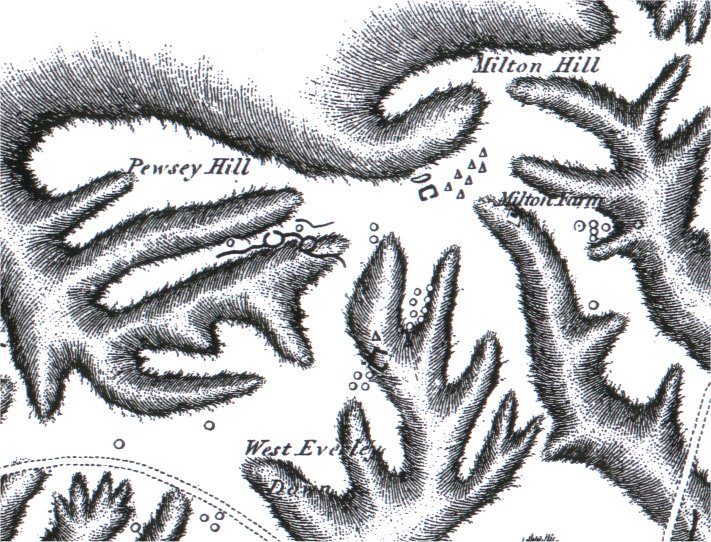
The area around Milton Hill from The Ancient History of Wiltshire Vol 1, showing the the Giants Grave Long Barrow, and the Everleigh Barrow Group at SU 184561.