


The only object of antiquity found with the skulls was a finely chipped arrowhead of flint of a beautiful leaf shape. The point of its more tapering extremity was broken off when found. It has been measured 2” in length by 9/10” in breadth; or 51 by 23 millimeters.

Giant’s Grave, Milton Lilbourne
This is one of the many Wiltshire long barrows excavated in the nineteenth century by Dr. John Thurnam.
Built of chalk, it is 90 m long, 20 m wide and 2 m high.
At its eastern end it covered a pile of bones of three or four people, one of whom had died from a blow which had cleft his skull.

The area marked as a Neolithic Occupation site, around marker 30, never contained a stone.
Animal bones and pottery marked this area out as either a shaman’s hut or a shrine.
The plinth used here has a flat, square top.

Still impressive, the fort is surrounded by two main banks 7.5 metres high, with deep ditches.

The modern world rumbles by on the ever busy A303.
Looking towards the farm track from the modern eighteenth century entrance. This was used by the annual sheep fair.

Some of the original ditches of the earthworks have become in-filled since they were dug back in 100 BC.

OS Trig point looking East towards the original entrance. This is the highest point in the area at 167m.

Ancient ramparts – Looking North over Madington Down towards Shrewton

Looking South around the kidney shaped entrance.

From the eighteenth century until 1916 an annual sheep fair was held inside the fort.
The sheep-pens have left rectangular ridge-traces on the eastern side of the central enclosure.

The farm track coming up from Berwick St. James, and the Langford Waie. This track leads to the summit of a hill with a water tower on top. It’s a good walk but safe.

I would suggest you try to get to SU 04104 40144. This point is a farm track, just off the South bound A303.
This milestone is actually listed as scheduled monument AM419 (SMR No. SU04SW525). Once you get to this point, the last obstacle is the A303 itself.

Yarnbury Castle by Sir Richard Colt Hoare from The Ancient History of Wiltshire Vol 1, 1812.
The road from Deptford to Amesbury is now the dual carridgeway of the A303, while the ancient trackway from Bath to Old Sarum, is still a track, but was once the roman road linking each town.

Bury Camp showing the hill fort’s outline with the original entrances at the NW & E.
The feature in the centre is an undated round barrow burial mound.
See ST87SW618
history.wiltshire.gov.uk/smr/getsmr.php?id=2301

One of the stones arranged around the hollow at the foot of the earthwork.

The dried up hollow at the foot of the earthwork may be a later pond. It did have a vibe though. Several large stones seemed to line its sides, maybe the remnants of something built from something else.

View showing the highest point of the earthwork at it’s furthest end. The hill side slopped away behind the picture, giving a natural defence. The area was also wooded now, but the earthwork may have once extended round the hills contours.

View looking along the rampart. The oak trees, although pretty, were undermining the earthwork and had invited badgers to build a set within their roots.

View looking along the rampart towards the valley. The two twisted ash trees mark the mid point of the earthwork, where the two sections merge. To the left of this is the dried up hollow or pond.


The “Happy Day” Stone and the Church.
One of the polystyrene stones used on the 1976 HTV Children’s drama, The Children of the Stones.
This stone was displayed during the 70th anniversary of the Alexander Keiller Museum opening in 1938.
Apparently, a local barn contains a dozen more of these fake stones which are pressed into service around the Avebury henge when required by visiting film makers. One such being the 1998 rock movie, Still Crazy

The “Happy Day” Stone and the Barn.
One of the polystyrene stones used on the 1976 HTV Children’s drama, The Children of the Stones.
This stone was displayed during the 70th anniversary of the Alexander Keiller Museum opening in 1938.

Re-drawn map of Conkwell Stone Circle taken from from Guy Underwood’s plan of 1946.
Local ragstones are shown as hollow shapes and the imported stones as solid.

Conkwell Stone Circle – Stones lie in the hedgerow beside the road. On Guy’s map, these would be No. 23, 24 and 25.

Conkwell Stone Circle – Stone No.9. This stone had been smothered in ivy, but was exactly as shown in Guy’s map of 1946.

Conkwell Stone Circle – Stone No.35. Again, this stone had been smothered in ivy, but was also exactly as shown in Guy’s map of 1946.

Conkwell Stone Circle – Stone No.8, 7 or 6. Although not buried, this stone was smothered in moss and leaf litter. Would require a second opinion as to which No. it is on Guy’s map of 1946.

Conkwell Stone Circle – Stone No.27.
This stone was biggest of the bunch at 6 feet in length. It had a “vibe”.

Conkwell Stone Circle – General view of the circle from the centre beside where stone No.1 stood on Guy’s map of 1946, looking towards the road that bisects the site.
This abandoned camp and tents seem to had been here for some time. They probably had no idea it was an ancient site. The “No Man’s Land” status refers to it lying on the Wiltshire/Somerset county border. I was told this was an area known in the past for squatters.

The Northern or Moon Circle
Stone No.207, The Half-a-day Stone reclines in the forground while the Stone of Many Faces, No.206 looks on. The background shows Stone No.201, The Broken Hearted Stone and Stone No.50, The Horse’s Head Stone, of the outer circle.


Looking West from Kitchen Barrow, towards Furze Knoll and Morgan’s Hill.

The Kitchen Long Barrow showing the remains from the only known excavation. Not recorded.

The Eastern side ditch of the Long Barrow looking towards Tan Hill.
A hare’s des-res.

The track up to Kitchen Long Barrow looking South towards the farm

Stone 10 – The Winter Queen’s Stone
Another aspect of the Goddess Tara is shown on the face of the Winter Queen Stone, as she looks out upon the mid-winter sunset.
Also shown are stones; number 9 – the back face of the Barber Stone, number 8 – The Unmoved Stone and number 7 – The Watcher of the South.


Cromlech in Clatford Bottom; “The Devil’s Den”
From “Guide to the British and Roman Antiquities of the North Wiltshire Downs”. by Revd. A. C. Smith, M.A. – 1884
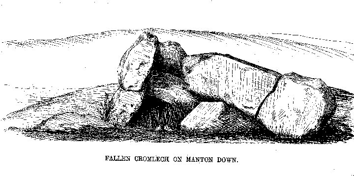
Fallen Cromlech on Manton Down
From “Guide to the British and Roman Antiquities of the North Wiltshire Downs” by Revd. A. C. Smith, M.A. – 1884

Fox Barrow looking north west towards towards Churn Knob and Churn Hill

Fox Barrow looking over the county hedge line north, towards Several Down and the Ridgeway

Fox Barrow looking south east towards the gallops and Compton Down

Fox Barrow looking along the hedge which marks the county line of Oxfordshire and Berkshire.
