

The view showing the track leading up to Lambourn Long Barrow. – This point marks the county line between Oxfordshire and Berkshire.

View of a bowl barrow from the L7B group and riding rail.

The view from the road leading into Lambourn. – This is the most westerly point of the barrow group and the closest to the original long barrow (known to be visible). This point also marks the county line between Oxfordshire and Berkshire. A strange border that is difficult to follow on the OS map, this looks like it was re-drawn many times in the ancient past, with the L7B barrow group and it’s outlining barrows, defining the territory of one tribe to that of another.

The Lambourn Seven barrows – View from the ancient track that runs beside the group.
Although there are some forty barrows in the vicinity altogether, only those in this enclosure beside the road may be visited without permission.
The barrows in this view use the numbering by L. V. Grinsell and Humphrey Case.
From left to right, No.8, two barrows enclosed within a single ditch, their mounds overlapping, suggesting that one is earlier than the other. To the right are No.6, a large bowl-barrow with No.7, a tiny barrow on its south side.
Next to this is No.5 a bowl-barrow 21m in diameter and 1.8m high, while behind is No.11 another bowl-barrow 3m high and 30m in diameter. Its contents are unknown.
The furthest barrow is No.10, which is another two barrows enclosed by a single ditch. A hollow on top of the north mound was made by Martin Atkins about 1850. He found the bones of an ox and a dog.

View of the western edge of the L7B group. The long barrow lies at the base of the trees on the left of the picture.
It may sound amazing that a barrow 220ft long and 50ft wide should have passed unnoticed, but one end of it was ploughed up, and this cart-track and grassy bank runs across the other end.

The cart track and grassy bank that runs over the southern end of the long barrow. The sarsen stones which originally formed the passage and chambers lay beneath this cart-track and had become exposed. This is what drew Mr L V Grinsell’s attention to the long barrow in 1935.

One of the sarsens from the burial chamber churned up and discarded.

The southern end of the long barrow with the recent fence running across the ancient monument

Looking out into the vale of the white horse

Dragon Hill as seen from the Uffington White Horse

Dragon Hill as seen from the road leading up to to the Uffington White Horse

Dragon Hill as seen from the road leading up to to the Uffington White Horse

The Uffington White Horse looking into the manger

The Uffington White Horse as seen from Dragon Hill

The Wansdyke on Tan Hill looking south

The Cove from the car park of the Red Lion.
Kodak Black and White Infra Red with R25 red filter. Rated at 1600 ASA dev in D76 for 10 mins at 20 degress Centigrade

Isometric view of the Roman bath complex and sacred spring of Sulis Minerva.
The top left hand corner contains the temple complex and the source of the sacred hot spring, which feeds the octagonal shaped reservoir. This hot water is then fed into the top left hand corner of the rectangular Great Bath. This was probably the hottest part of the bath and may have been reserved for the most prodigious patrons of the bath house.
Other cold immersion pools line the top edges of the complex, while the sacred hot spring water gradually cools off as it drains to the lower pools before exiting via a culvert in the Abbey courtyard.

The pump room at night.
The flood lit fountain at the far end of the room dates from the height of the Georgian period of Bath’s grandeur. This was built directly above the sacred hot spring and Roman reservoir.
This photo was taken at night through the French windows of the pump room, which open out into the Abbey courtyard. The high Alter lies 20 feet directly below my feet with the temple lying due west under the present pavement and Stall Street.

Bowl barrow, what bowl barrow? The road widening has cut away the southern section leaving little to see. Stonehenge and Fargo plantation can be seen in the distance.

View showing the cutting made for the enlarged A303 in 1960. The barrow’s position near Stonehenge would indicate some importance to the resident. A C14 date of 1670 bc +/- 90 has been recorded.

Overall view of the barrow looking towards the A303. This shows how reduced the barrow has become since excavation by Paul Ashbee in 1960.

Roughridge Hill Long Barrow^- SU 05486576
The existence of this long barrow was unsuspected until aerial photography revealed its flanking side ditches in the 1950’s.
It lies in a generally E-W direction, 1000 m ESE of Shepherd’s Shore, and Immediately S of the vallum of the Wansdyke.
An Ordnance Survey Field Officer estimated the mound to be 70.0 m long, approximatelly 40.0 m wide, and up to 2.5 m high. `The ditch on the south is ploughed out and is visible only as a soil mark, but on the north a short portion of the ditch, up to 0.7 m deep, protrudes from beneath the Wansdyke which overlies it’.
The Western end of the mound has since been shortened by ploughing.
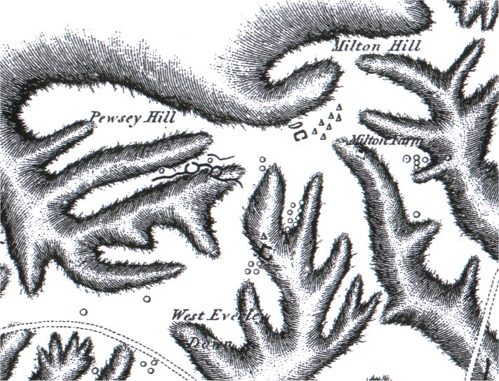
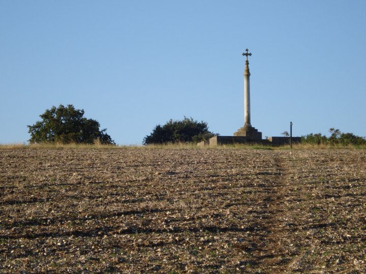
The area around Milton Hill from The Ancient History of Wiltshire Vol 1, showing the the Giants Grave Long Barrow, and the Everleigh Barrow Group at SU 184561.

The Everleigh barrows group are classified as the five barrow cluster at SU 184561.
I have included a map based on the SMR numbering for clarity. Prefix the numbers with SU15NE i.e. SU15NE655, for search at history.wiltshire.gov.uk/smr/
Bowl Barrow (654) – Excavated by Hoare c1800 and again opened by Thurnam who found it to be unproductive. 13.5m diam x 0.3m high.
Bowl Barrow (655) – Flattened
Disc Barrow (656) – Excavated by Thurnam in the 19th century, who found it unproductive. Mound Overall diam 59m, mound 0.3m high, ditch 0.7m deep, bank 0.5m high.
Bell Barrow (657) – Opened by Thurnam who found a primary cremation which was probably male and an intrusive extended, undated skeleton. Mound 81ft x 11ft, berm 18ft, ditch 15ft x 2.5ft. It is well-preserved and grass covered.
Bell Barrow (658) – Opened by Thurnam who found a primary cremation with a flat axe-dagger. Mound Overall dima 50m x 3.2m high, with a 0.5m deep ditch.

The remains of the West Kennet Avenue on the southern side of the A4.
Stone 82b was toppled over and lies partly buried on the field boundary
beside the busy A4.
Other Avenue stones in or below the hedge, are 79b, 80b, and 81b.
Stone 83b was seen by Passmore in 1926, but is now covered in soil.

View from the Ancient Ridgeway looking south.
On the right is Adam’s Grave Long Barrow, on the left is Knap Hill, while ahead lies Woodbourgh Hill and the southern most remains of the Ridgeway itself.

The entrance to West Kennet Avenue 14 May 1724 by William Stukeley

William Stukeley’s view of the entrance to West Kennet Avenue in 1724
The stone at the top of the avenue is 4b, the Bison stone.
The positions of avenue stones 1a and 1b are shown broken off to the stumps, two years earlier.

West Kennet Avenue – Stone No.3a
The stump of Stone No. 3a, the most northerly stone of the avenue which lies besides the chaulk path leading to the rest of the avenue stones.
Follow this path by crossing the road and through the gates, all the way to The Sanctuary for the full Avebury experience.

West Kennet Avenue – Stone No.3a
The stump of Stone No. 3a, the most northerly stone of the avenue which lies besides the chaulk path leading to the rest of the avenue stones.
Follow this path by crossing the road and through the gates, all the way to The Sanctuary for the full Avebury experience.

West Kennet Avenue – Stone No.3a and fragments
The most northerly stone of the avenue is stone No.3a, seen here with fragments of other sarsens.
The background shows the road and the chaulk path leading to the gate.

West Kennet Avenue – Top Section
The top section of the avenue where it joins the main circle.
Stone No. 5 of the SW quarter can be seen in the distance, beyond the road.
The foreground shows the chaulk path leading from the bank and ditch.
Avenue Stone No.2a whould have stood directley in front of this view.

The North Down cemetery. The oldest barrow is this Neolithic long barrow (now only 20cm higher than the surrounding field) – Scheduled Monument : SM21861
A bowl barrow was built in the Bronze Age close to the longbarrow, and around this focus were built the many other round barrows of the cemetery

The Long barrow at the heart of the cemetery – Scheduled Monument : SM21861
Excavation in 1964 by Dr Isobel Smith, revealed Neolithic sherds and animal bones, including 3 ox skulls, but no burials.
It also showed the barrow had been opened before, probably by Thurnam.
A round barrow overlies the NE end.
The forground shows the main Devizes to Beckhampton road.

Prospect of the temple on Overton Hill – 8th July 1723
Abury – A Temple of the British Druids
by William Stukeley

Does this capstone over the entrance to the barrow contain an animal’s head?
Some claim to have seen the carving of a deer, others a water buffalo. Is this natural or not?
If this stone is genuine, and replaced in its original position after restoration, it would have been visible even after the barrow was sealed up.

Western side of Rybury showing the depth of the surviving ditch
Excavation of the main site has shown ditch segments 2 m deep and flat bottomed.

The view East with the pinnacle of Adam’s Grave in the distance.

This mysterious megalith seems to have a seat built-in.
The inscription on the back reads
Molly William Daw 1916 – 2002

This mysterious megalith sits on the Western side of Rybury. Probably not natural but may easily have come from a part of the ancient Avebury landscape.
The inscription reads
Herbert William Daw 14 April 1915 – 1 November 1993

Some sections of Rybury have survived well

Looking North towards Tan Hill.
This section of the earth work has been flattened by the 18c. chalk diggings.

Overall view of the Neolithic and Iron age outworks as seen from Tan Hill
The site’s eastern side shows the Neolithic ditches the best.
The outer ditch being Neolithic, the inner being Iron Age.

The Neolithic and Iron age outworks as seen from Tan Hill

The outwork of Clifford’s Hill as seen from Rybury.
This is on another smaller knoll, and is an arc with a chord of about 250 ft. with 7 segments of ditch.

Ground plan of the chamber and gallery
Engraving of the excavations made by Dr. John Thurnam in 1859.
The excavation was made from the top of the barrow and out through the gallery to the courtyard. The side chambers were not discovered until the later excavations.

View of the gallery looking through the chamber
Engraving of the excavations made by Dr. John Thurnam in 1859.
The excavation was made from the top of the barrow and out through the gallery to the courtyard. The side chambers were not discovered until the later excavations.

View of the chamber looking through the entrance
Engraving of the excavations made by Dr. John Thurnam in 1859.
The excavation was made from the top of the barrow and out through the gallery to the courtyard. The side chambers were not discovered until the later excavations.