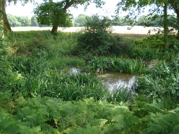
The sunken pond seemed to be a natural feature and may well have been the reason it was built here to begin with.
Image credit: Chance - June 2009
The sunken pond seemed to be a natural feature and may well have been the reason it was built here to begin with.

The farm track looking south and the edge of the sunken pond


The flat interior of the fort looking towards Walls Copse and the county line of Berkshire

Membury Fort as seen from the footbridge crossing the M4. The farm track leads past the old airfield to the north entrance in the trees

View showing Height and shape of Silver Barrow

Animal proof fencing encases Silver Barrow but still the animals persist with their digging

Tank Marks made before Silver Barrow was protected by the wooden posts

Tank Marks – Roy Canham, the Head Wiltshire County Archaeologist, was instrumental in getting archaeological conservation carried out on the Salisbury Plain Military Training Area. These wooden post could date back 20 years to when the problems where first addressed.

For more information on the MOD Salisbury Plain Military Training Area and the protection of ancient monuments, see
Managing for Effective Archaeological Conservation: The Example of Salisbury Plain Military Training Area. By Roy Canham and Christopher Chippindale, in Journal of Field Archaeology, Vol. 15, No. 1 (Spring, 1988), pp. 53-65.

Overall shape of the Silver Barrow from the North

The side ditches created in the barrows construction are still easy to identify.

South side of Silver Barrow showing extensive damage caused by the badger setts.

View of the valley looking towards Old Ditch
Longbarrow and White Barrow .

Roman coin showing head Of Captive Gaul 48 BCE stuck after the Gallic Wars
As many as a million people (probably 1 in 4 of the Gauls) died, another million were enslaved, 300 tribes were subjugated and 800 cities were destroyed during the Gallic Wars.
The entire population of the city of Avaricum (Bourges) (40,000 in all) were slaughtered.
During Julius Caesar’s campaign against the Helvetii (present-day Switzerland) approximately 60% of the tribe was destroyed, and another 20% was taken into slavery.
see
en.wikipedia.org/wiki/File:RomanSilverDenariusWithHeadOfCaptiveGaul48BCE.JPG

Plan of Bibracte showing the topography of the site with the plateau du Couvent, the inner and outer ramparts and the boundaries of départements, Nièvre (58) and Saône-et-Loire (71)
Source – en.wikipedia.org/wiki/File:Plan_Bibracte-fr.svg

Little Avebury Stone Circle with the Ridgeway in the background

Looking south towards the Packway with army traffic

Some features remain but the site is much disturbed

Bumps in the ground and an outer bank – Looking North

When I first visited this site I spoke to an old lady in the other church, just over the spring in Alton Barnes. She called this stone “The Maiden Stone” and then added, some say “The Virgin Stone”. It who be interesting to know if it has ever been properly examined. Maybe it’s the remains of a handfasting or oath stone like the one Stukeley saw at Avebury

The 1,700 year-old yew tree in the churchyard. Two trees have formed from one.
Got a big fertility vibe out of the whole site.

Plan of the central Stone Structure at Stonehenge as it survives today.
Stone numbers are those conventionally used in the recent literature and following Petrie, F. 1880. Stone types are shown as sarsen or blue stone. The ref. to sandstone is for the Alter stone, No.80

Stonehenge Plan showing the different features of the sight and their positions
1 = The Altar Stone, a six ton monolith of green micaceous sandstone from Wales
2 = barrow without a burial
3 = “barrows” (without burials)
4 = the fallen Slaughter Stone, 4.9 metres long
5 = the Heel Stone
6 = two of originally four Station Stones
7 = ditch
8 = inner bank
9 = outer bank
10 = The Avenue, a parallel pair of ditches and banks leading 3 km to the River Avon
11 = ring of 30 pits called the Y Holes
12 = ring of 30 pits called the Z Holes
13 = circle of 56 pits, known as the Aubrey holes
14 = smaller southern entrance
The plan omits the trilithon lintels for clarity. Holes that no longer, or never, contained stones are shown as open circles and stones visible today are shown coloured, grey for sarsen and blue for the imported stone, mainly bluestone.

View looking towards Alfred’s Castle from the edge of the cemetery

View of the interlocking ditches made out in cow parsley.

View looking across Idstone Down from the top of the middle barrow. Ashdown house can be seen on the right. On the far right lies the access track by the medieval farm house. The track on the far left is a bridle way which runs through the middle of the cemetery.

Close up of the curious marks on the Cove Stone.
Created by the roots of palm trees or are they the marker lines for astrological events?

The cove viewed from the East looking West showing the curious marks either left by the roots of palm trees or by the creators of Avebury. If this stone was one of the first erected, than did the same people leave their mark?

Detail from the ceiling mural in the pool room of the Barge at Honeystreet showing Picked Hill.
This mural by Vince Palmer features Wiltshire’s ancient monuments – Stonehenge, Avebury and Silbury Hill – woven together with circles, triangles and swirls that have been spotted the fields nearby.
See themodernantiquarian.com/facility/50
or web site the-barge-inn.com/index.htm

Croppy Central
Map of the Avebury area on the wall of the Barge at Honeystreet. Each dot represents a crop circle and the colour shows the year it happened. Great pub to explore See themodernantiquarian.com/facility/50
or web site the-barge-inn.com/index.htm

Detail from Vince Palmers’ ceiling mural in the pool room of the Barge at Honeystreet showing Avebury looking south. See themodernantiquarian.com/facility/50 for directions.

Detail showing the mortice from the fallen lintel of stone 156

The dressing of the sarsens seems to have been carried out in several stages of increasing delicacy.
Initially, the rough and irregular surface appears to have been reduced by working parallel grooves about 9 ins. wide and 2 to 3 inches deep, generally running longitudinally, using the larger mauls of 20 to 30 Ibs. in weight.
Examples of tooling left in this state can be seen on the upper (outer) face of stone 59 as shown above and on the lower part of the outer face of stone 54

View of the Eastern bank with the new golf buggy track

View showing the area leading up to the clubhouse


View of the northern area showing the much reduced pillow mounds

View of the new golf buggy track as it descends into the Western banks.
This is the area contain the main bailey and is very overgrown

View of the Eastern bank with the new golf buggy track


The remains of a subterranean chamber perhaps? Ideal den for a fox

View from the top looking down the track towards La Grosse Pérotte and the vandalised information post

View from side showing one of the areas of stone removed.

View from inside showing what may have been a pet’s grave.

View from side showing one of the areas of stone removed.

View from side showing thickness of capstone and one of the areas of stone removed.
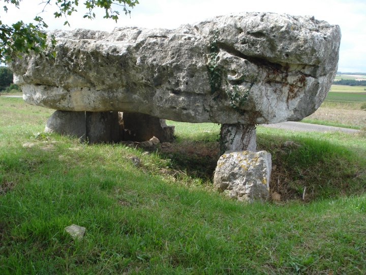
View from side showing distance from the road