
New gate and fence enclosure for the central Old King Barrow. Another Barrow can be seen through the trees
Image credit: Chance - March 2008
New gate and fence enclosure for the central Old King Barrow. Another Barrow can be seen through the trees

View looking at the course of the Avenue, the hollow, over King Barrows Ridge

The route of the Avenue over King Barrows Ridge between the Old and New King Barrow groups
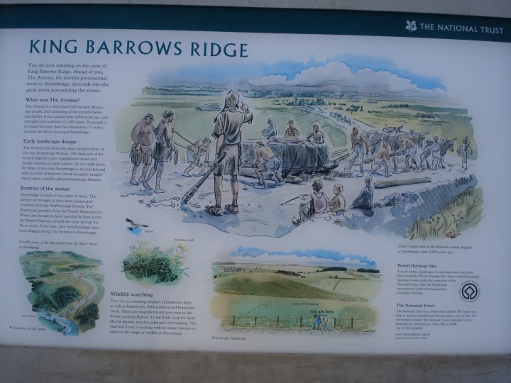
Artist impression of King Barrows Ridge showing the movement of the Stonehenge’s Sarsens

View of Kings Barrow Ridge from the last barrow looking south

Kings Barrow Ridge showing barrows and beech trees planted in 1722 by Lord Pembroke

View looking along part of Kings Barrow Ridge

Cutting back hazel and forming new wildlife habitat on Kings Barrow Ridge

Modern grave where ashes were scattered on Kings Barrow Ridge

Artist impression of a burial on Kings Barrow Ridge

Looking from the centre of one disc barrow, across the site. See the aerial view from the SMR for a clearing sense of scale
history.wiltshire.gov.uk/smr/getsmr.php?id=17835

The barrows as seen from the field boundary

Very difficult to photograph, two 46m diameter disc barrows

Detail of the two connected disc barrows from the track surrounded by trees.

Overall view of the site from the track leading into the valley. The two connected disc barrows are on the left and the single bowl barrow can be seen on the crest of the hill on the far right.

Charlie – Skeleton of an infant girl, lying just as she was found, on a bed of compacted chalk from the ditch of Windmill Hill.

One of the exceptional array of reconstructed pots represent daily life in this important village of five thousand years ago.

Flint axe and Red Deer antler from Alexander Keiller Museum

Cremation urn and remains from Alexander Keiller’s’ excavations of Windmill Hill

Neolithic Man showing fashion and facial type based upon excavated clues by English Heritage

Skeleton of a primitive small working dog from Alexander Keiller’s excavations of Windmill Hill

Skeleton of a primitive goat from Alexander Keiller’s’ excavations of Windmill Hill.

Skeleton of a primitive piglet from Alexander Keiller’s excavations of Windmill Hill. These native animals were fast runners and lived in the ancient forests.

Interpretation model of the West Kennett palisade enclosures, The Sanctuary and Silbury Hill as seen looking East. From the Great Barn, part of the Alexander Keiller Museum.

Interpretation model of the West Kennett palisade enclosures and The Sanctuary from the Great Barn, part of the Alexander Keiller Museum

Interpretation of the Eastern side of the Avebury complex looking West. Model from the Great Barn and created by MDM Props Ltd. Hearne Hill – London

Flint axe from Alexander Keiller Museum

Plate from the Merewether excavations of Silbury Hill on display in the Alexander Keiller Museum

Interpretation of the various building stages of Silbury Hill

Beaker from a burial on the West Kennett Avenue

Beaker from a Child Burial at Beckhampton

Haydon Hill as seen from the ancient Western trackway leading from Scots Poor and the Tidcombe Long Barrow


This pond is noted by Colt Hoare on his visit to the hillfort in Ancient Wiltshire, he states that the ponds were reputed to “never run dry”. This one really has a mystical energy and may have been the site of the plague victims’ camp.

The larger and deeper of the two natural ponds that lie within the Iron Age defences.

View of the Eastern banks and ditches showing some of the ancient beech trees and patches of sweet woodruff.

The smaller of the two natural ponds which the Iron Age defences encircle.

The Northern section of the bank, from the bottom of the ditch, showing the height difference. This area contains some ancient oak trees.

View looking South with the Roman Chute causeway running along the horizon into Hampshire.


View of the Western section of the Iron Age defences

The newly constructed fence mirrors the Iron Age defences

The newly constructed fence mirrors the Iron Age defences

View showing the height of the existing banks and ditches.

One of the later entrances cut through the Iron Age defences with the Roman Chute causeway running along the horizon.

View from Fosbury showing the Iron Age bivallate defences looking South towards Vernham Dean.

View from Fosbury showing the Iron Age bivallate defences of the hillfort and the Roman Chute causeway running around the Northern and Western sides.

View of Fosbury from the Roman road, the Chute causeway, showing the defences, field systems and storage pits.

Detail from The Ancient History of Wiltshire Vol 1

Dragon Hill as seen from the Icknield Way just west of Britchcombe Farm showing part of the campsite