Kirriemore Cairn
markj99

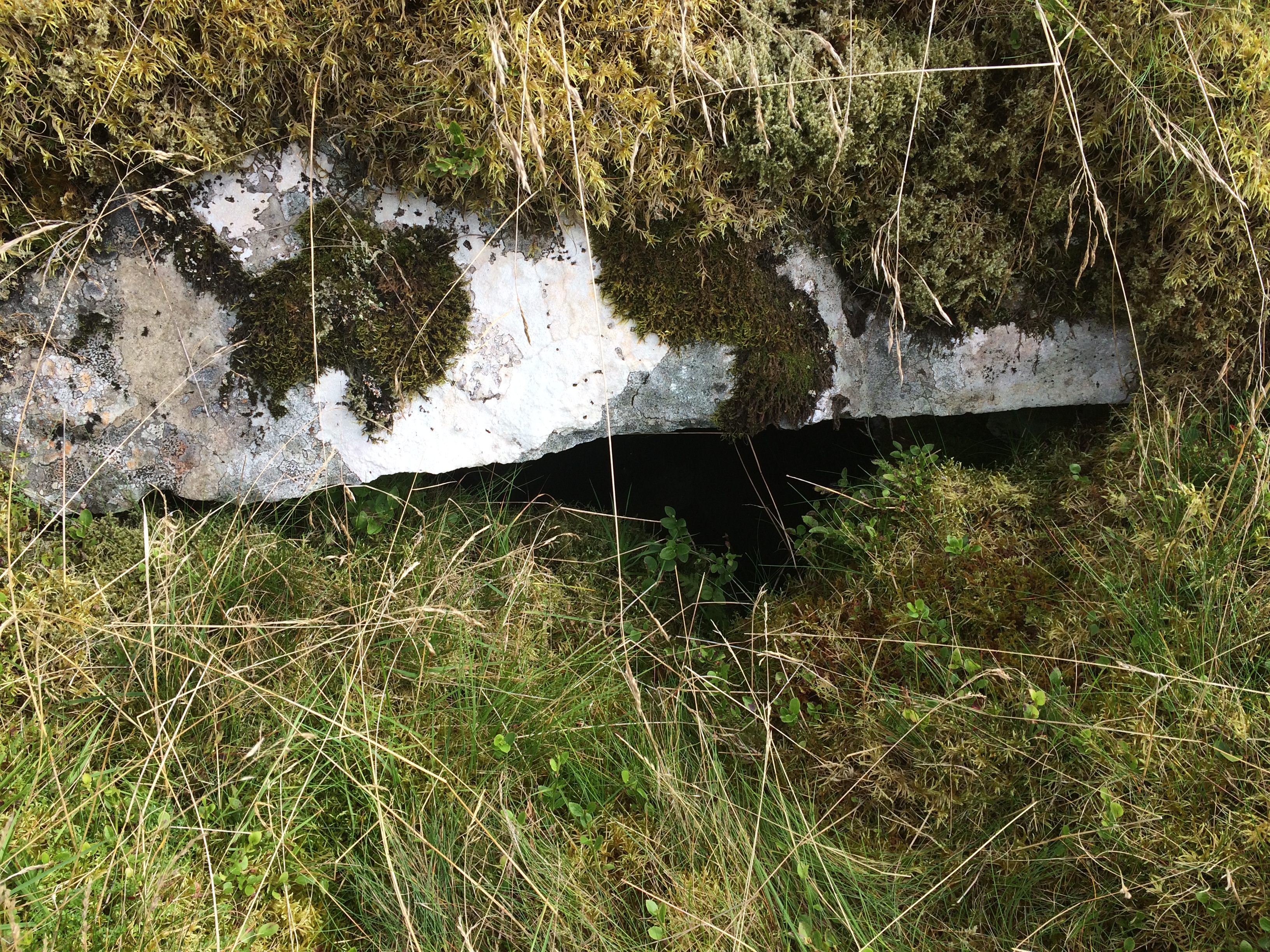

Passage and chamber exposed on a E-W axis of Kirriemore Cairn.
Image credit: Mark Johnstone


Kirriemore Cairn is hidden in mature forest c. 3 miles W of Kirriereoch Hill. It is a chambered cairn c. 30 yards across constructed on a slope. There has been extensive robbing on the W hemisphere and an off-centre excavation exposing a chamber in the S hemisphere. The entry into the chamber is narrow so I didn’t try to enter, using my camera to view the interior. There is a carpet of green moss on the undisturbed S side covering mostly small stones. Canmore ID 63043 (go to Links) identifies this as King’s Cairn, however there is no local information for this name.
A crude modern cairn has been constructed in the S quadrant of the cairn circle.
Directions: From Newton Stewart take the A714 Girvan road turn R at Bargrenan for Glentrool Village. Follow this road for around 5 miles. Turn R for Kirriereoch on a rough track. Take the 1st R after around 0.75 miles. Follow this track for another 0.75 miles turning R over a bridge. Turn R again for 500 yards then bear L at the next junction. After 0.5 miles the cairn will be on your R in a forest clearing.

Cairn Avel viewed from SE, Carsphairn in the background.
Image credit: Mark Johnstone
Cairn Avel is a stone cairn, 0.3 miles SW of Carnavel Farm on the outskirts of Carsphairn.
This robbed cairn retains a significant presence on the horizon. The W half of the long cairn has been almost entirely robbed out leaving a low scatter of stones on the W end. A sheepfold and stone walls have been constructed close to Cairn Avel. The E half is almost intact reaching up to 10 feet high, with some excavations. However, the later addition of a c. 3 feet high cairn on top of the E half of Cairn Avel spoils it’s classical shape. The long cairn measures c. 110 feet E-W and c. 75 feet N-S on the E end, tapering to 30 feet on the W end.
Cairn Avel is accessed by following an old pack horse path to Carnavel Farm. Parking is now prohibited at Carnavel Farm junction. Park in a lay-by c. 500 yards NW then walk back to the start of the public path. Walk through Carnavel Farm When the public path heads S up the hill at the start of moorland head N then W round the margin of a rough pasture field to a stone mound c. 250 yards W. This detour avoids boggy ground on a direct route to Cairn Avel. My route can be viewed on Cairn Avel.
Directions: There is room to park at Carnavel Farm junction on the W side of Carsphain just before you cross the bridge. Follow the path to Polmaddy uphill for 1.5 miles until you observe Bardennoch hill trig point on your L. Continue on this path for a further 300 yards then bear NE over moorland until you reach a fence. Follow this fence E for several hundred yards until you reach a gate and dry stane dyke at NX 5685 9120. Bardennoch Cairn in overlain by this dyke.


Small stones carpeted by moss on Bardenoch Cairn NW hemisphere.
Image credit: Mark Johnstone

Bardennoch Cairn NW hollow containing two larger stones.
Image credit: Mark Johnstone
Bardennoch Cairn
Bardennoch Cairn is a round cairn situated 1.25 miles S of Carsphairn. It has been reduced to ground level but retains a circular plan around 20 yards in diameter. The cairn is divided by a dry stane dyke, two thirds on the NW, one third on the SE. It is composed almost entirely of small stones covered in soft green moss giving it a patina of age. There is a NW off-centre grassy hollow with two larger stones c. 3 feet by 1 foot within 1 yard of the wall however it is too shallow to be a chamber, more of an exploratory pit. The stones may be remnants of dry stane dyke construction.
Canmore ID 63862 (go to Links) speculates on the existence of a capstone but it was not observed in situ.
Sheuchan’s Cairn


Overview of Sheuchan’s Cairn’s exposed chamber.
Image credit: Mark Johnstone


An irregular hollow in the NW quadrant of Sheuchan’s Cairn.
Image credit: Mark Johnstone
I found some old pictures on a flash drive of Sheuchan’s Cairn on Brecklach Hill taken in 2012. Since I had no recollection of where it was or how I got there I decided to visit again to update its current status.
This was indeed fortuitous given the change in Sheuchan’s Cairn circumstances. Previously it had been sheltered in a clearing on thickly forested Brecklach Hill, now it was a clear spot in the devastation that tree felling leaves behind. The cairn itself has not changed.
Sheuchan’s Cairn is a moss covered chambered cairn around 20 yards across by 2 yards high. There have been several desecrations especially in the centre of the cairn in a NE-SW axis. A chamber with a dressed stone has been exposed in the SW quadrant. There is a significant irregular hollow in the NW quadrant which doesn’t resemble a chamber.
Directions: From Newton Stewart take the A714 to Girvan. At Bargrennan turn L for Glentrool Village. Stay on this road for 6 miles until you reach an un-signposted L turn at a crossroads (NX 3645 8508). No unauthorised vehicles are allowed on this road so it’s a long walk or short cycle if you come prepared. Follow this rough forest road for 1.75 miles until you come to a Y junction at NX 3420 8418. Take the L road for around 300 yards, look R and you will see a green spot on the brow of the hill at NX 3379 8387. Make your way around 250 yards through the broken ground, ditches and tree stumps to Sheuchan’s Cairn.
Canmore ID 68800 (go to Links) gives a full description of Sheuchan’s Cairn.


Cairnfore Cairn, Kirriereoch
Cairnfore is a robbed out cairn just over the South Ayrshire border 250 yards from the B road between Glentrool Village and Straiton.
It is around 25 yards across and 5 feet high with a robbed out centre axis. The cairn’s stones have not travelled far: there is an adjacent sheepfold and enclosure. The moss covering over the cairn gives it an air of antiquity and its circle of trees add to the ambiance.
Cairnfore is catalogued as Canmore ID 63042 (go to Links).
Directions: From Newton Stewart take the A714 Girvan road turn R at Bargrenan for Glentrool Village. Follow this road for around 5 miles. After the Kirriereoch sign park up in the next L for Ferter Forestry Road around 0.5 miles later.
Walk N for 125 yards until there is a gap in the trees covered in ferns. The use of a GPS device is almost essential as there is not an official path to Cairnfore Cairn at NX 3554 8707. Make your best way uphill to this grid ref or cairn symbol on your map. It is around 250 yards uphill to the clearing with the cairn & sheepfold.
The map reference given on the plaque is confusing. The Muckle Stane was moved from a nearby field but NS 285 360 is in the middle of the sea. If you transpose the numbers NS 360 285 is in Monkton & Prestwick New Cemetery.
Dane Love (Ayrshire: Discovering A County (2003)) states that it was originally sited in a field off Charles Avenue.
This curious erratic boulder was moved into the centre of Monkton in 1998 according to the plaque. The boulder is quite impressive however the reason for its preservation is not given.
It’s easy to visit if you are in the area. Head for Monkton and turn onto Burnside Road at the traffic lights, its on your L after 20 yards.


Dun Ibrig: a broch or a dun?


The outer stone wall surrounding large stones in the centre of Dun Ibrig.
Image credit: Mark Johnstone
Dun Ibrig lies c. 1 mile W of Scarinish, the largest community on Tiree. The site may be a ruined broch or a dun according to Canmore ID 21533 (go to Links).
The Broch/Dun is situated on a virtual island surrounded by a circle of water bordered by very boggy marshland. I made my way carefully to the edge of the dun but the water was too deep to proceed further. I did get to see the outer stone wall surrounding large stones in the centre.
From Scarinish head W and take the 1st R after 1.5 miles. After 400 yards park up and head due E into the bog. Maybe Dun Ibrig will be accessible in a dry summer or frozen winter.

Stone Lined Passage of Avielochan Clava Cairn from the chamber.
Image credit: Mark Johnstone


Clearance stones dumped on Milton of Larg Cairn.
Image credit: Mark Johnstone
Milton of Larg Cairn
Milton of Larg Cairn is typical of cairns found in a pastoral landscape. Past generations of farmers have found a use for the stones, then used the denuded cairn for dumping field clearance stones, building it up again.
The cairn, some 25 yards across, has a circular profile in the field due to the remaining grassy kerb however there is a hollowed out N quadrant. A substantial quantity of field clearance stones have been dumped on the W side of the cairn.
Milton of Larg Cairn lies 30 yards SE of the minor road from Castle Kennedy to New Luce, half a mile shy of New Luce. It’s possible to park in the gateway opposite the cairn.
Canmore ID 61622 (go to Links) furnishes further details of the cairn.
Dun Beag, Vaul
Auld Wife’s Grave Chambered Cairn