
Finnarts Hill Standing Stones

Finnarts Hill Standing Stones alignment viewed from N.

Finnarts Hill Standing Stones alignment viewed from S.

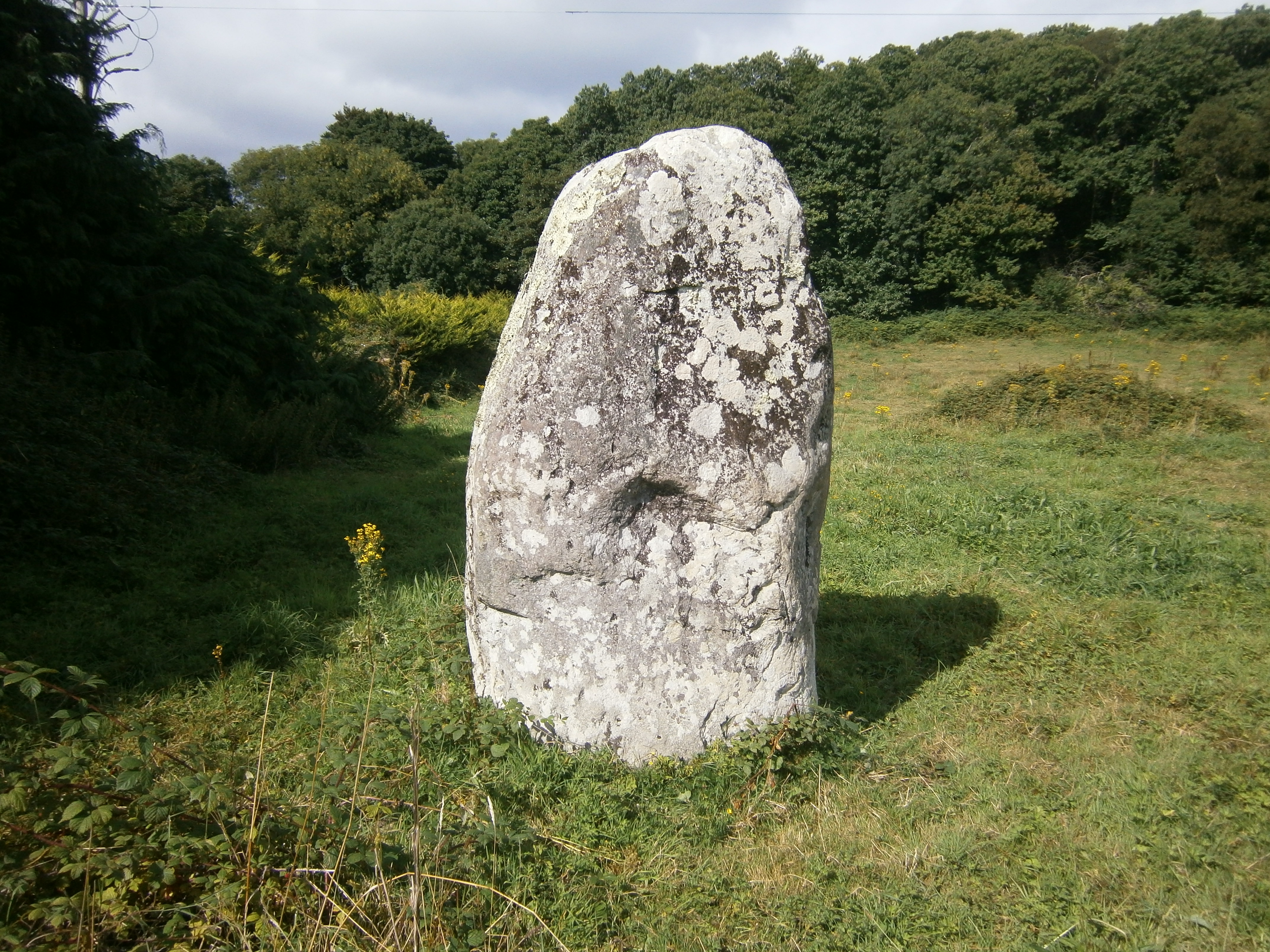
Finnarts Hill Standing Stone A

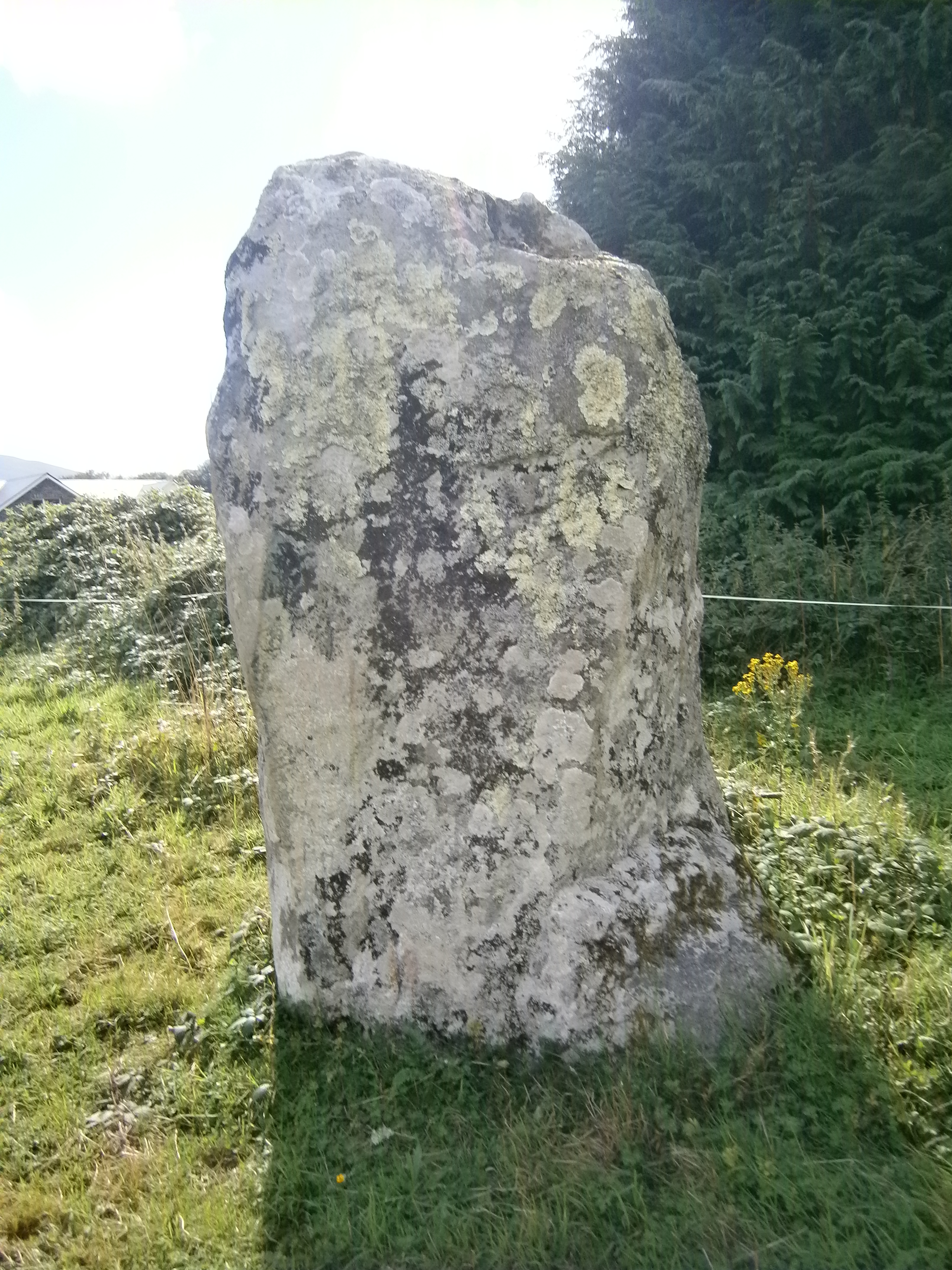
Finnarts Hill Standing Stone B. The possible c. 30 degrees shear plane on top of the stone is evident.
Finnarts Hill Standing Stones are a small pair of stones on the Ayrshire Coastal Path (ACP) between Glen App and Ballantrae. Finnarts Hill lies on the Loch Ryan coast. The standing stones are small, 1 yard and 0.5 yards high respectively. The stones are 15 yards apart in a N-S alignment. They are situated in wet moorland adjacent to the ACP.
Canmore ID 60914 speculates that the smaller stone may be a stump of a taller broken stone. The top of the stone has a possible c. 30 degrees shear plane. However there are no other stones within a 10 yard radius.
Directions: Opposite Glenapp Church on the A75 there is a small car park at the start of the ACP. Follow the road S for over 0.5 miles until the ACP veers R off the road uphill onto a rough rocky track. After ascending for c. 1 mile the ACP reaches a pass between Finnarts Hill and Sandloch Hill. Finnarts Hill Standing Stones are on the L side around 20 yards from the track.
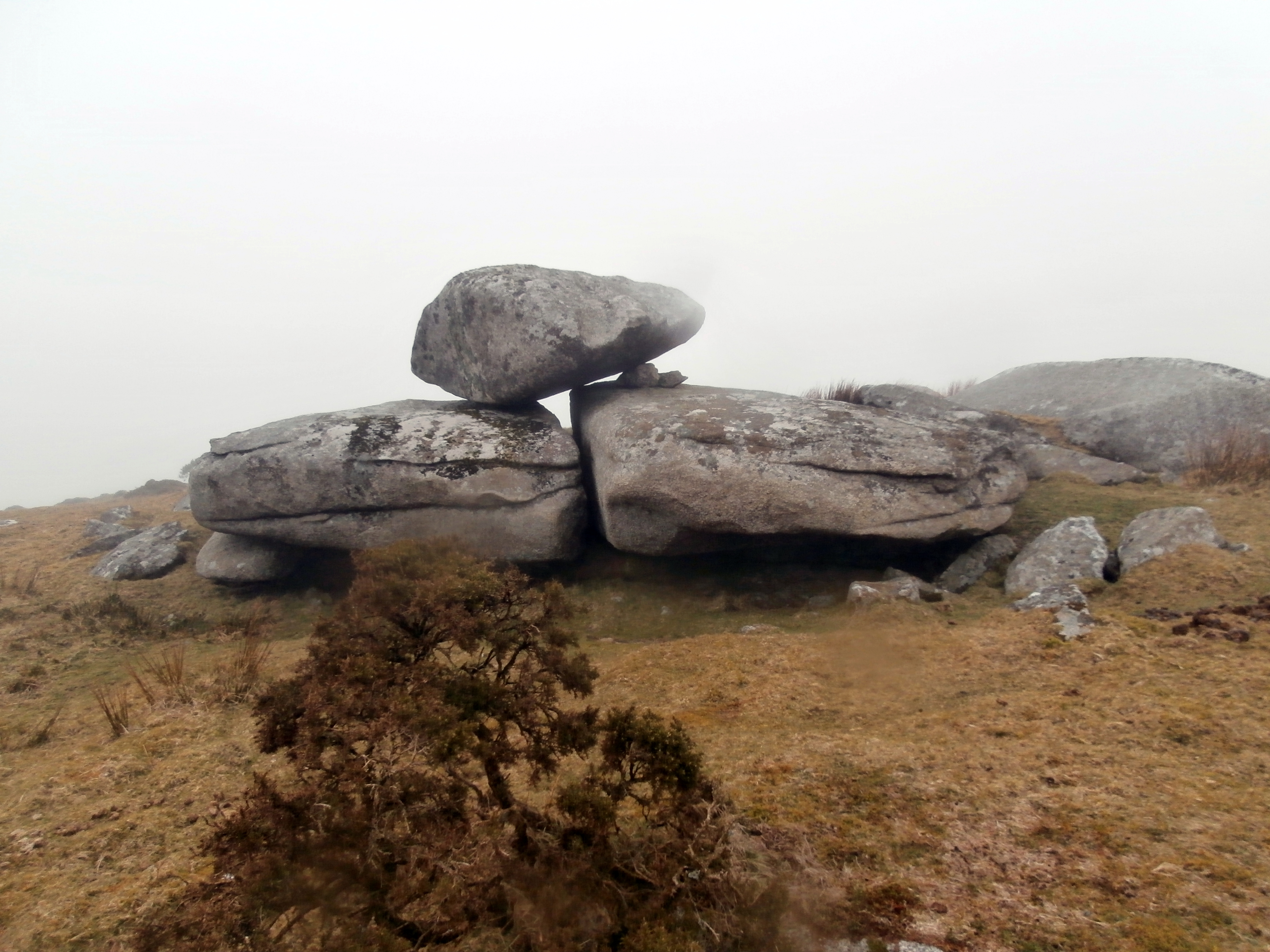
Elephant Rock (Hendra Downs)

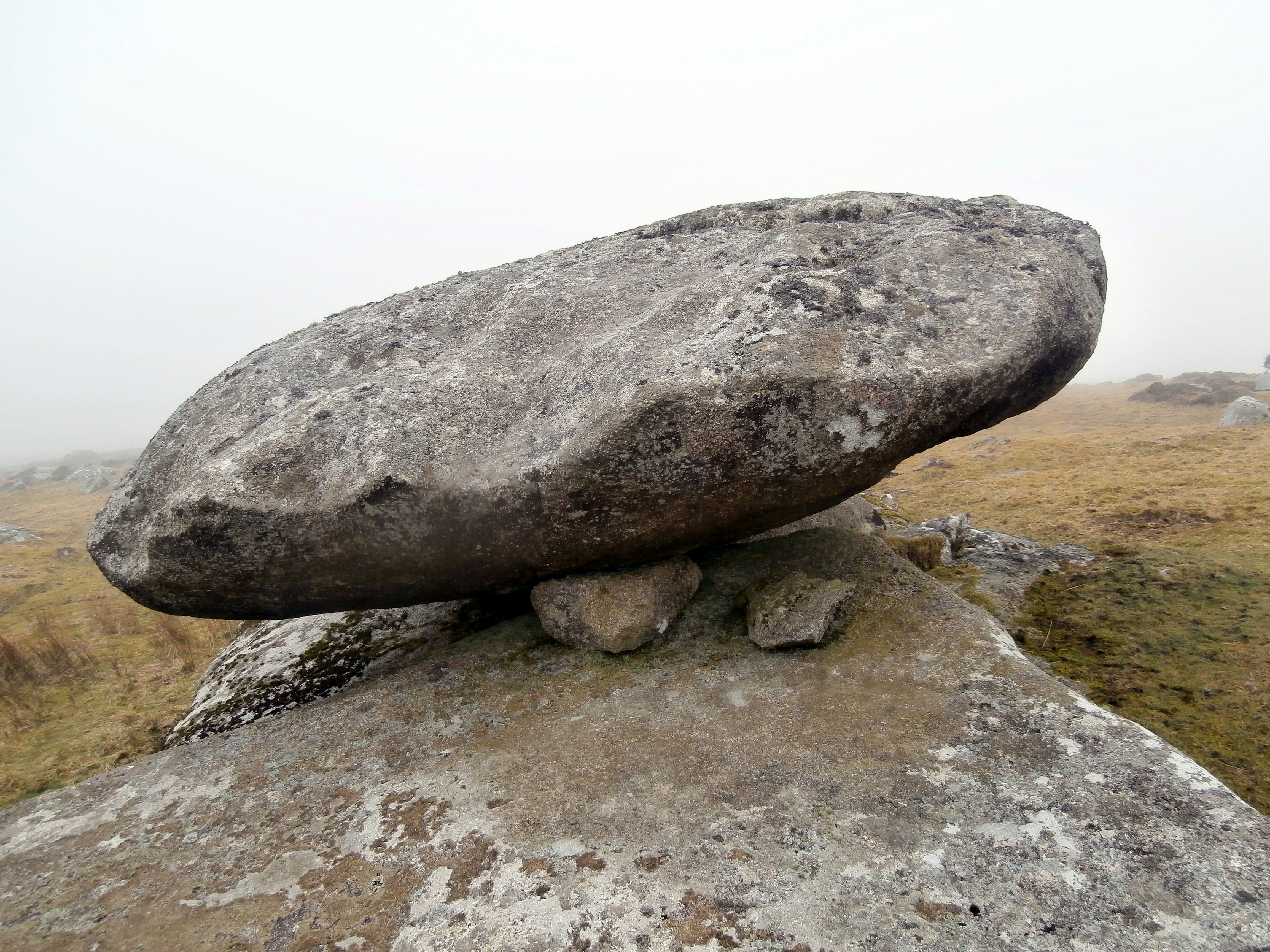
Elephant Rock (Hendra Downs)
Elephant Rock (Hendra Downs) looking N to The Beacon summit.
Elephant Rock is a large boulder balanced precariously on two flat rocks around 250 yards S of The Beacon summit on Hendra Downs. The delicate balance of the rock may be an optical illusion as it has survived longer than many logan stones however I elected not to test this hypothesis. I wanted to preserve Elephant Rock for fellow TMAers.
Turn R at this junction for Balevullin Bay. Take next R
after 250 yards for blue Parking sign. Car park is 500 yards down a narrow track.

Dun Boraige Beag viewed from coastal path looking N.

SE arc of outer wall on Dun Boraige Beag.

Dun Boraige Beag viewed from S, possible SW entrance left centre of frame.

The grassy interior of Dun Boraige Beag dominated by a mysterious boulder.

The N arc of Dun Boraige Beag protected by the sea.
Dun Boraige Beag
Dun Boraige Beag is a ruined dun on Balevullin Bay in Tiree. It is sited on a rocky promontory barely above sea level. A course of large stones remains on the SE arc of Dun Boraige Beag. There is a gap in the outer wall on the SW quadrant, possibly the entrance to the dun. The grassy interior is around 10 yards in diameter, uneven ground with no obvious features save a large central stone. The purpose of this boulder measuring c. 5x3x3 feet is unclear.
Canmore ID 21447 (go to Links) furnishes further details on this site.
Directions: From Scarinish head N on the B8065 for around 7 miles until you reach Balevullin. At the road end follow the Baile a Mhuilinn sign R then 250 yards later turn R down a narrow lane signed with a blue parking sign. You will reach the car park in 500 yards. A rough track heads NW out of the car park. Follow this track round the coast for around 300 yards and look N for a low lying promontory with a line of large stones on the coast. Dun Boraige Moire is around 300 yards W of Dun Boraige Beag on a natural knoll 100 yards from the shore.
Dun Boraige Moire
Dun Edinbain


Drumuie Standing stone, c. 6 feet high, is erected 2.5 miles N of Portree on the Isle of Skye. It can be viewed from the A87, the road to Uig. However it is easier to take the L cul-de-sac signposted to Drumuie.
There is a passing place down this road allowing easy access to the standing stone.
Directions: approaching Porteee from S take the A87 Uig L on the edge of town. Follow this road uphill for 2.5 miles until reaching the L cul-de-sac Drumuie Junction. Park in a passing place 100 yards down this road to access Drumuie Standing stone.

Approaching Drumuie Standing Stone from E.


View of Drumuie Standing Stone from Drumuie dead end road, 2.5 miles N of Portree, Isle of Skye.
Drumacissock South Cairn


Drumacissock South Cairn stone scatter on a robbed out cairn, looking W to Penwhirn Reservoir road.
Drumacissock South Cairn is one of a pair of robbed out cairns on moorland 0.75 miles S of Penwhirn Reservoir. It is 20 foot across, reduced to ground level with a 4 x 5 foot scatter of stones on top.
According to Canmore ID 62509 (go to Links) these stones may have once been a small pen or shelter, now ruined. It lies 50 yards E of the minor road between Craigcaffie and Penwhirn Reservoir.
Its companion, Drumacissock North is 100 yards N, parallel to the road.
Directions: From Stranraer follow the A77 Ayr road. After passing the A751 Innermessan junction take the next R 500 yards later into an unsigned single track road. Follow this road for 3.5 miles to reach the bombed factory site. Cross the cattle grid, proceed for 0.33 miles to a passing place and look R into the moorland to locate Drumacissock North Cairn 50 yards E of the road.

Drumacissock North Cairn viewed from the road.


Looking W from Drumacissock North Cairn to passing place on minor road.

Partial arc of stones on Drumacissock North Cairn.
Drumacissock North Cairn
Drumacissock North Cairn lies 50 yards E of the minor road between Craigcaffie and Penwhirn reservoir. It is a robbed out cairn around 15 yards across reduced to ground level with an incomplete arc of stones. It is difficult to spot Drumacissock North Cairn from the roadside in its moorland location.
Canmore ID 61510 (go to Links) gives further information on Drumacissock North Cairn. As the name implies there is a Drumacissock South Cairn. It is 100 yards S of Drumacissock North Cairn parallel to the road.
Directions: From Stranraer follow the A77 Ayr road. After passing the A751 Innermessan junction take the next R 500 yards later into an unsigned single track road. Follow this road for 3.5 miles to reach the bombed factory site. Cross the cattle grid, proceed for 0.33 miles to a passing place and look R into the moorland to locate Drumacissock North Cairn 50 yards E of the road.


Laigh Sinniness Promontory Fort

Laigh Sinniness fort viewed from SE on the Stairhaven Coastal Path.

Modern entrance in NE cut into outer rampart of Laigh Sinniness fort.

Inside Laigh Sinniness fort, viewed along NE-SW axis.
Laigh Sinniness Fort is on the Luce Bay coast between Stairhaven and Auchenmalg. Its main axis run from NE to SW. The fort is naturally protected by a cliff on the E & the coast to the S. A substantial 7 foot earth rampart protects the N & W landward sides.
Canmore ID 62239 (go to Links) states there was an internal stone wall but it has now been reduced to a flat scatter of stones 20 x 10 yards in area. A ruined dry stane dyke overlies the stone scatter on the SE.
Canmore names the fort as Garliachen, however, since the name is not in current use Laigh Sinniness farm, 300 yards N of the fort seems a more appropriate reference point.
Directions: Directions: At the top of the A75 Glenluce Bypass take the A747 Port William road. After 3.5 miles you reach Auchenmalg. Around 500 yards later The Cock Inn car park is a convenient starting point or the grassy bank on the coast 500 yards further on if that is busy. Head onto the beach and walk W past a house with a picket fence. Around 200 yards later there is an obvious cutting on the R which leads up to a private farm road. Follow this road W round a corner up to the Stairhaven Coastal Path which cuts off L up a slope. This path is roughly defined through overgrown vegetation and walking boots are recommended. Follow this path for 1.25 miles until you see the fort on your L and Laigh Sinniness farm on your R.
Court Cairn, The May on Google Maps