
The central hollow in Stalldown Stone Row Cairn NE. It may be the site of a removed cist.
Image credit: Mark Johnstone
The central hollow in Stalldown Stone Row Cairn NE. It may be the site of a removed cist.

Stalldown Stone Row Cairn S in situ.

The grassy low lying remains of Stalldown Stone Row Cairn S.
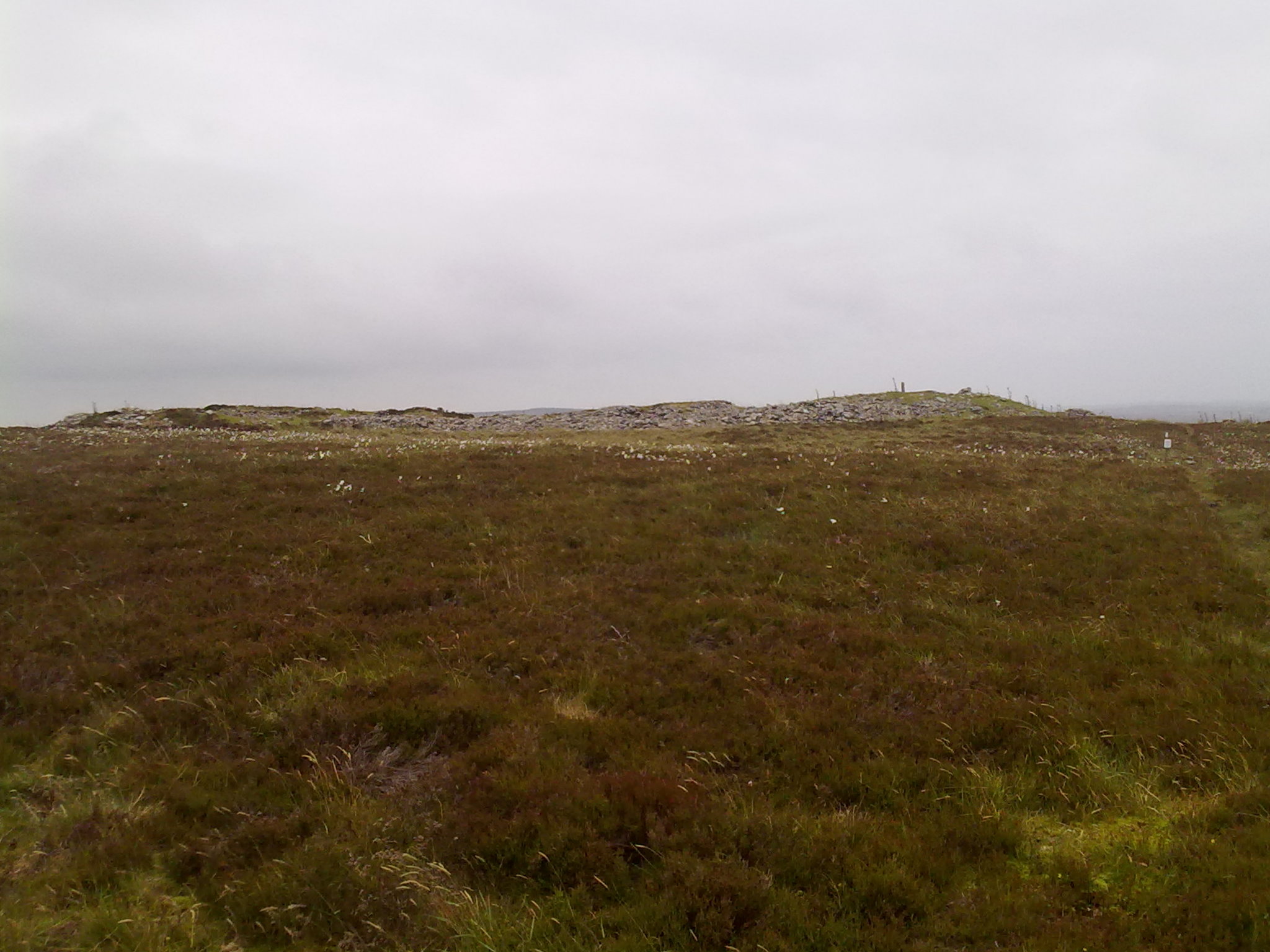
The ruined cairn lies c. 250 yards S of the Southern terminus in Stalldown Stone Row. It has been reduced to a circle of rough uneven grassy lumps, measuring c. 10 yards across by 1 yard high. The dark green of the cairn contrasts with the light brown of the moorland.
Historic England 1012748 states that the centre of the cairn has a central hollow probably related to a past disturbance in search of a cist. It also speculates that the cairn may have been the original terminus of the stone row. The Stalldown area has been used for peat cutting in the past so some of the stones may have been removed or buried. In any case, the close proximity of the cairn to Stalldown Stone Row extends the area of the Stalldown Complex.
In its isolated situation in the Modern World, Stalldown Stone Row would seem to be an ancient monument frozen in time. However, Historic England states that Stalldown Stone Row is in an area where peat has been cut so the stone row may not be as original as it appears. In fact, Historic England speculates that many of the stones may have been restored in slightly different locations.
Historic England’s description of Stalldown Stone Row and its associated cairns.
Stair Haven Broch on Canmore
Street View St Breock Wind Farm Barrow on Google Maps.
South Yarrows S Long Cairn profile along the E-W Axis viewed from S.
Canmore discusses the possibility that the South Yarrows S long cairn was an extension of an existing round chambered cairn.
Yarrows has a full description of South Yarrows Broch and its neighbouring buildings.
South Yarrows N has an extensive description of this ruined long cairn.

The entrance to South Yarrows Broch and its intra-mural passage.
Street View of South Cairnweil
South Cairnweil Standing Stone is a triangular granite pillar reaching a rounded top at c. 7 feet. The basal cross-section of 3’3’’x2’4’’x8’’ is maintained until the last foot of the stone. According to Canmore ID 60446 (go to Links) the stone was removed sometime between 1911 and 1970. It was re-erected in its original position by the farmer in 1973.
Directions: Take the A77 Portpatrick out of Stranraer heading S. After 1.33 miles ignore the Portpatrick R turn staying straight on the A716 Drummore. After another c. 6.5 miles go past Sandhead, take the next R for Kirkmadrine Stones. After 0.4 mile turn R onto a minor road for Kirkmadrine Stones. After c. 0.45 miles you will see a small lay-by at NX 08654 48386 with a gate where South Cairnweil Standing Stone Path starts. The stone is about 180 yards S from this point beside the path.
South Cairnweil Stading Stone


A small vegetation covered mound on Slewcairn NE.
Slewcairn NE Cairn
Slewcairn NE is one of a pair of cairns situated c. 0.25 miles E of Slewcairn Long Cairn. It is a grassy cairn completely robbed of stones and hidden in the trees. It lies in a clearing c. 50 yards from the forest track. According to Canmore ID 65494 (go to Links) it measures c. 10 yards across by up to 1 yard high. There is a small mound on the apex, c. 2 feet high, covered in vegetation.
Slewcairn SW, its near neighbour, lies about 130 yards SW across the forest road in open ground.
I visited the Slewcairn complex on 12.05.12.
Slewcairn can be approached from the North, my choice of access. This involves 5 miles of forestry track which can be tackled by foot, bike or car.
By foot a 10 mile return plus up to 1 mile of deviation between 3 sites makes for a 11 mile walk.
By mountain bike the effort to travel 10 miles on a forest track is greatly reduced, my choice for my visit.
By car, preferably 4x4, 10 miles on a forestry track is reduced to 30 minutes travel at 20mph.
When you reach NX 92824 61374 (GPS navigation is essential) you are equidistant between Slewcairn SW & NE. Neither are easily spotted. Slewcairn NE is hidden in trees at NX 9284 6143. Slewcairn SW is on a rocky rig at NX 9276 6133. Slewcairn Long Cairn is 0.25 miles W along a forest ride starting at NX 92619 61592. Walk W on this narrow clearing for c. 300 yards to the end of the trees. Slewcairn Long Cairn is c. 130 yards S of this point lying in rough terrain at NX 9239 6142 The grid references for each cairn are as recorded in Canmore.
Take the A711 for Dalbeattie at Cargenbridge on the edge of Dumfries. Bear L onto a narrow lane in Beeswing 100 yards before the church. After about 3.75 miles on this road take the R turn for Solway Fishery. After c. 300 yards there is room to park on your R at NX 9370 6632. You can walk or cycle from here on continue on by car bearing SE at first for c. 5 miles along a forest track.


Slewcairn SW Cairn
Slewcairn SW is one of a pair of cairns situated c. 0.25 miles E of Slewcairn Long Cairn. It is almost completely robbed of stones on a rig c. 60 yards SW of the forest track at NX 92824 61374. According to Canmore ID 65492 (go to Links) it measures 10 yards across and up to 1 yard high. It is heather covered with a small scattering of stones on top. A modern cairn c. 2 feet high has been built on top of the cairn.
Slewcairn NE, its near neighbour, lies about 130 yards NE hidden in the trees.
I visited the Slewcairn complex on 12.05.12.
Slewcairn can be approached from the North, my choice of access. This involves 5 miles of forestry track which can be tackled by foot, bike or car.
By foot a 10 mile return plus up to 1 mile of deviation between 3 sites makes for a 11 mile walk.
By mountain bike the effort to travel 10 miles on a forest track is greatly reduced, my choice for my visit.
By car, preferably 4x4, 10 miles on a forestry track is reduced to 30 minutes travel at 20mph.
When you reach NX 92824 61374 (GPS navigation is essential) you are equidistant between Slewcairn SW & NE. Neither are easily spotted. Slewcairn NE is hidden in trees at NX 9284 6143. Slewcairn SW is on a rocky rig at NX 9276 6133. Slewcairn Long Cairn is 0.25 miles W along a forest ride starting at NX 92619 61592. Walk W on this narrow clearing for c. 300 yards to the end of the trees. Slewcairn Long Cairn is c. 130 yards S of this point lying in rough terrain at NX 9239 6142 The grid references for each cairn are as recorded in Canmore.
Take the A711 for Dalbeattie at Cargenbridge on the edge of Dumfries. Bear L onto a narrow lane in Beeswing 100 yards before the church. After about 3.75 miles on this road take the R turn for Solway Fishery. After c. 300 yards there is room to park on your R at NX 9370 6632. You can walk or cycle from here on continue on by car bearing SE at first for c. 5 miles along a forest track.
Slewcairn Long Cairn

The River Camel flows past the Slaughter Bridge Stone.

The Slaughter Bridge Stone lies beside the River Camel.

A recumbent triangular stone located within 5 yards of the earthfast triangular stone. Are they stones shaped by man?

A squat triangular stone located in the vicinity of Sibleyback Menhir.

The narrow edge of Sheffield Menhir.

The boundary wall is built around Sheffield Menhir.

Sheffield Menhir overgrown by ivy.

A cluster of small Cup Markings on Rubha Charnain Panel.

Double Cup Marking found on Rubha Charnain panel.

Interpretation panel of Roches Moutonnees at Dulnain Bridge.

A line of Roches Moutonnees viewed along the shallow slopes.

The broad humpback top of a Roche Moutonnee.
A view of the steep lee side of a Roche Moutonnee.
On the Eastern edge of Dulnain Bridge, a village in Strathspey, there are some unusually shaped rocks known as Roches Moutonnees. The term describes rocks which have been shaped by the passage of a glacier. The characteristic shape is a smooth shallow slope in the direction of the glaciers advance with a steep edge in the lee of the glacier. About 18000 years ago Dulnain Bridge was covered by a vast ice sheet moving E and measuring up to 700m deep.
These rocks are small examples of the form which is found throughout the Cairngorm area. Ord Ban near Aviemore is a massive example, reaching up to 428 metres high.
Directions: There is a lay-by at NJ 0021 2497 on the E edge of Dulnain Bridge. A short path leads to the Roches Moutonnees.

Several Cup and Ring Marks are evident on Robin Hood’s Stone directly above the plaque.

The narrow edge of Redhouse NE, measuring up to 1.5 feet, supports the capstone theory.

The broad face of Redhouse NE resembles a capstone.


The narrow side of Redhouse SW measures almost 2 feet.

Redhouse SW is a squat classically shaped standing stone, tapering to a thin rounded point.
Redhouse Standing Stones are c. 100 yards apart in adjacent fields. There is no line of sight between them and they are dissimilar types of stones. They lie at SW and NE on the compass.
Redhouse SW is a classic standing stone shape with a large cross-section tapering to a thin rounded top.
Redhouse NE is a broad thin earthfast slab. Bladup thought it was originally a capstone which has been erected upright. I would agree with this theory. It could be the only remaining stone of a ploughed out chambered cairn set upright as a rubbing stone.

A large, probably natural, hollow near the top of Ravenswood Avenue Standing Stone.
Street View of Rangag West