
Embedded Stones in SW Quadrant of Pinbreck Hill Cairn.
Image credit: Mark Johnstone
Embedded Stones in SW Quadrant of Pinbreck Hill Cairn.

Pinbreck Hill on Google Maps.
Visited 14.07.24
There is an isolated cairn on the summit of Pinbreck Hill, located c. 5 miles E of Barr Village in South Ayrshire. The oval cairn measures c. 40 feet NW-SE and 35 feet NE-SW, reaching up to 3 feet high. It has been largely robbed of stones leaving a grassy surface studded with embedded small stones. The kerb of the cairn is delineated by intermittent embedded medium-sized stones. A modern cairn, measuring c. 1.5 feet high, has been constructed in the centre of the mound around a rusting iron fence post. Canmore ID 63060 has further details of Pinbreck Hill Cairn. There are extensive 360° views from the summit of Pinbreck Hill, compensation for a tussocky walk up a c. 30° slope.
Directions to Cairn Hill (Cairnryan): My route starts at Cairnryan Village Hall, adjacent to P&O Ferry Terminal. Park up at Cairnryan Village Hall. Walk N for c. 300 yards, cross the grass onto Claddyburn Terrace. Take the private single track lane to High Croach that bears left from Claddyburn Terrace. Follow this track uphill for c. 0.9 miles to NX 0796 6846. Turn left into a gateway heading W towards a gate in corner of the field. Head W along the dry stane dyke for c.140 yards to reach a gate into a rough pasture field. Walk c. 170 yards WSW towards a gate in the field. In the next field head WNW for c. 130 yards to another gate leading into a large field. Proceed NNW for c. 650 yards to a gate in the NW corner of the field. A 4x4 track heads NW into a boggy area turning W towards the grassy summit of Cairn Hill. There is a trig point on the summit. The remains of the cairn are a low grassy mound c. 15 yards ESE of the trig point. My route is viewable on Cairn Hill (Cairnryan) Cairn.
Once you leave the road the route may be boggy so waterproof footwear is recommended.
Directions to Drummuckloch Hill Cairn:My route starts at the car park at Cairnryan Village Hall, adjacent to P&O Ferry Terminal. Walk N for c. 300 yards, cross the grass onto Claddyburn Terrace. Take the private single track lane to High Croach that bears left from Claddyburn Terrace. Follow this track uphill for c. 0.9 miles to a faint track starting on the right side of the track at NX 0804 6854. Take a 4x4 track S uphill over rough pasture towards a dry stane dyke. Follow the dry stane dyke S for c. 0.5 mile to reach a short dry stane dyke. Drummuckloch Hill Standing Stone is located on the end of this dyke. Walk c. 70 yards SSE towards a circle of marsh grass concealing Drummuckloch Hill Cairn,c. 20 yards NE of the dry stane dyke. Once you leave the road the route may be boggy so waterproof footwear is recommended. My route is viewable on Drummuckloch Hill Cairn.
Directions to Drummuckloch Hill Standing Stone: My route starts at the car park at Cairnryan Village Hall, adjacent to P&O Ferry Terminal. Walk N for c. 300 yards, cross the grass onto Claddyburn Terrace. Take the private single track lane to High Croach that bears left from Claddyburn Terrace. Follow this track uphill for c. 0.9 miles to a faint track starting on the right side of the track at NX 0804 6854. Take a 4x4 track S uphill over rough pasture towards a dry stane dyke. Follow the dry stane dyke S for c. 0.5 mile to reach a short dry stane dyke. Drummuckloch Hill Standing Stone is located on the end of this dyke. Walk c. 70 yards SSE towards a circle of marsh grass concealing Drummuckloch Hill Cairn,c. 20 yards NE of the dry stane dyke. Once you leave the road the route may be boggy so waterproof footwear is recommended.My route is viewable on Drummuckloch Hill Cairn.
Directions to Eagle Cairn (Cardryne): Take the A716 to Drummore. Turn right in the centre of Drummore following the Mull of Galloway sign. Bear left at the top of Mill Street following the B7041. Bear sharp right after 250 yards towards the Mull of Galloway. Stay on the B7041 for 0.8 miles to reach a crossroads. Go straight on up the minor unsigned road. Follow this road for c. 250 yards, bear left onto an unsigned single track lane. Follow this lane for c. 1.6 miles to reach a rough parking place on the right at a disused gateway. A farm track starts 50 yards S of the lay-by, heading NE into pasture. My route avoiding electric fences is viewable on Eagle Cairn (Cardryne).

Cairn Hill (Cairnryan) Cairn viewed from NE.

Cairn Hill (Cairnryan) Cairn viewed from ESE.

Cairn Hill (Cairnryan) Cairn viewed from WNW.
Visited 23.06.24
There was a cairn on the summit of Cairn Hill, c. 0.33 miles N of Cairnryan in Dumfries and Galloway. According to Canmore ID 60646, all that remained in 1985 was “a spread of stones measuring 25m in diameter and rising up to 0.3m in height around the edges.” On my visit I observed a grassy circle c. 25 yards in diameter c. 15 yards ESE of the summit trig point. There were no stones visible on the surface or underfoot.
Canmore states that Cairn Hill (Cairnryan) Cairn is also known as Cairn Multibrugh.
Visited 16.06.24
Drummuckloch Hill Cairn is located in rough pasture c. 0.75 miles E of Cairnryan in Dumfries and Galloway. The ruined cairn is obscured by clumps of marsh grass. Canmore ID 60677 states that the mound “measures 7m in diameter by a maximum of 0.4m in height.”
There may be a relationship between Drummuckloch Hill Cairn and Drummuckloch Hill Standing Stone which lies c. 70 yards SSE of the stone.

Drummuckloch ?Hill Cairn viewed from N.

Drummuckloch ?Hill Cairn viewed from E.

Drummuckloch ?Hill Cairn viewed from S.

Drummuckloch ?Hill Cairn viewed from W.


Drummuckloch Hill Standing Stone viewed from ENE.

Drummuckloch Hill Standing Stone viewed from SSE.

Drummuckloch Hill Standing Stone viewed from WSW.

Drummuckloch Hill Standing Stone viewed from NNW.
Visited 16.06.24
Drummuckloch Hill Standing Stone is located in rough pasture c. 0.75 miles E of Cairnryan in Dumfries and Galloway. The undressed stone slab measures c. 4.5 feet in height with a c. 3 x 1.5 feet cross section. The long axis is orientated NNW-SSE. A modern dry stane dyke has been constructed c. 6 feet W of the stone, running c. 30 yards ENE to the nearest boundary wall. Drummuckloch Hill Standing Stone is listed as Canmore ID 60678.
There may be a relationship between Drummuckloch Hill Standing Stone and Drummuckloch Hill Cairn which lies c. 70 yards SSE of the stone.

E Half of Eagle Cairn (Cardryne) viewed from NNE.

E Half of Eagle Cairn (Cardryne) viewed from ESE.

E Half of Eagle Cairn (Cardryne) viewed from SSW.

W Half of Eagle Cairn (Cardryne) viewed from NNE.

W Half of Eagle Cairn (Cardryne) viewed from SSW.

W Half of Eagle Cairn (Cardryne) viewed from WNW.

Stones in E Half of Eagle Cairn (Cardryne) viewed from ESE.

Embedded Stones in W Half of Eagle Cairn (Cardryne) viewed from WNW
Visited 12.06.24
Eagle Cairn (Cardryne) is a ruined cairn in Dumfries and Galloway with a spectacular panorama including sea views and the Mull of Galloway Lighthouse. The mound has been bisected by a dry stane dyke running NNE to SSW. The western half is better preserved, measuring c. 12 feet wide of the dry stane dyke up to 1 feet high with embedded stones scattered in the grassy surface. The eastern half has been reduced to a prominence in the field, measuring c. 1 foot high and 6 feet wide of the dry stane dyke. Further information is available in Canmore ID 61065.
The route to the cairn is cross country starting at a lay-by at NX 1192 3301 opposite Cardryne Croft. Follow a farm track NE then walk round the perimeter of a field to a gate, detour round rough ground towards the ruined cairn. My route is viewable on Eagle Cairn (Cardryne).

Apron Full Of Stones Cairn viewed from SSW.

Apron Full Of Stones Cairn viewed from SSW

Standing Stone (c. 5°) of Achmore Stone Circle, previously buried in peat up to tip of stone. (02.07.11)

Recumbent Stone (c.35°) of Achmore Stone Circle. (02.07.11)

Standing Stone (c. 70°) of Achmore Stone Circle. (02.07.11)

Recumbent Stone (c. 215°) of Achmore Stone Circle. (02.07.11)
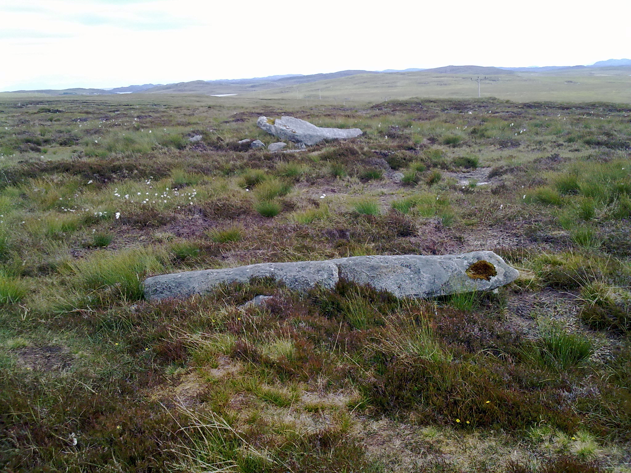
Recumbent Stone (c. 240°) of Achmore Stone Circle. (02.07.11)

Little Balsmith Standing Stone is incorporated into a dry stane dyke on a minor road 1.5 miles E of Whithorn in Dumfries and Galloway.

Little Balsmith Standing Stone viewed from NW.

Little Balsmith Standing Stone viewed from NW.

Little Balsmith Standing Stone viewed from SE.

Buldoo Recumbent Stone viewed from SW looking towards Buldoo Standing Stone.
Directions to Millmoan Hill Cairn
There is a minor junction off the A77 at NX 0820 7530, c. 80 yards SW of the Dupin Farm junction on the Glen App straight. There is room for one car to park at the locked gate. It is the start of a forest track winding uphill for c. 1.3 miles to a modern fire tower. Millmoan Hill Cairn is located c. 100 yards S in a wide clearing. My route can be viewed on Millmoan Hill Cairn. (I saw several deer grazing on my way back as this is a road less travelled.)


