
The largest of 3 barrows South West of Stagsbury Hill. This is quite a large mound and probably not used as a Medieval pillow mound as far as I could tell and also retains its ditch, just.
Image credit: A R Cane
The largest of 3 barrows South West of Stagsbury Hill. This is quite a large mound and probably not used as a Medieval pillow mound as far as I could tell and also retains its ditch, just.

Looking South West. A bit scarred from this position.

Stagsbury Hill, field system and local pony club!

Two mutilated barrows beyond Stagsbury Hill.

I love it when barrows have names even if it probably dates back only as far as the middle ages and was maybe a practice target for archers. Quite well preserved and about 2m high and 5-6m across. The structure which once stood on top has now gone and just a few scattered bricks remain, possibly consumed by rabbits.

Like a small island in a sea of green grass.

Still quite a pronounced ditch around it which generally fills up with water in the Winter.

Interesting stone alignment next to it! Actually It’s probably something to do with the nearby former RAF Stoney Cross airfield as was the brick structure that’s now gone from the top.

Wandering in Wandlebury! This is the only way to see the fort. Due to the thick vegetation (mostly yew), it’s all but invisible from a distance, but it’s quite a good size and takes about half an hour to stroll around.

The stable building is all that remains from the original building within the fort. Viewed from the bank and (slightly cleared) ditch.


Battlesbury, field systems and Middle Hill viewed from Scratchbury.

The largest bowl barrow on the hill with one of those archaeological star sign thingammies on top.


Looking West along the Southern ramparts with Cley Hill just visible on the left.

The impressive earthworks (and field systems) of Battlesbury viewed from the equally magnificent ramparts of nearby Scratchbury.

Aerial view with Warminster off to the left. Didn’t actually get to climb up it as we were running out of light, energy and drone battery. Impressed nonetheless.

Panoramic aerial view looking vaguely Northwards.

At the Southern end of the hill fort with a great view across the valley towards Mere.

Standing on the innermost earthwork of the hill fort. The distance between the three earthworks is quite unusual you’d be pushed to call the spaces in between ‘ditches’.

The largest BA barrow on the hill next to the NCE.

Two of the smaller barrows adjacent to the NCE and to a bit of quarrying.

The faint ring of the causewayed enclosure visible to the left and foreground with three BA barrows external to it.

4000 years of continual usage. The Neolithic causewayed enclosure to the North followed by a Bronze Age barrow, an Iron Age cross dyke and the IA hill fort to the South.

The earthworks at the Southern end of Whitesheet Hill. The saucer-like barrow in the centre of the fort might well be relatively modern.

Scrub clearance reveals the extent to which the perimeter earthworks have been mauled and diminished over the centuries.

Looking SE from the SE corner of the enclosure. The huge ridge dyke is hidden within the trees and bushes on the left in the distance.


The (recently cleared) enclosure, known as St. George’s Church yard on East Hill.

Earthworks on the South Western side. One of the Morgans Hill linear BA barrow groups just visible in the distance to the left.


A tremendous amount of upheaval in the landscape here.

The view down to the long barrow, slightly left of centre.

A modern (1780!) interloper on this ancient landscape.

The Eastern opening in the fort’s defences.


Approaching the barrow along the Old Bath Road track.

There’s more to this than meets the eye.

A mid-holiday walk to the Ring. Never fails to impress.

We only had a road map to aid our navigation to this site . Having parked up in Boroughbridge it took ages to find someone who new what The Devil’s Arrows were and also how to get to it. Surprising how clue-less some people are about what’s under their noses! Glad we did find it though – what amazing stones these are!

All three menhirs. The southern-most stone nestles within it’s leafy surroundings on the left.

Middle and northern-most stones, one of which is pretending to be the trunk of an oak tree.

The most southerly menhir in the group. You can just about see the other two across the hedge and the shortest one appears to be in the middle, which it isn’t, so they’re not in perfect alignment sadly....there again, so what? it was some feat just standing up these monsters!
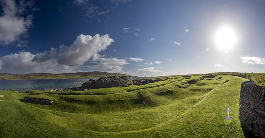
Panorama of the broch and it’s outer banks and ditches. The Island of Rousay crouches in the background trying to lure us, but we were strong (and running out of time and money).

The broch in it’s wonderful entirety with the shadow of a man scratching his head in confusion.


