
The most westerly barrow of the linear group.
Image credit: A R Cane
The most westerly barrow of the linear group.

Two small barrows which appear to be almost conjoined on Fitzhall Heath, part of Iping Common, looking North near the parking area just off the A272.


View across a frozen pond on Fitzhall Heath with three of the five linear round barrows almost visible beyond.

Close up of the largest barrow on Fitzhall Heath looking West.

Two of the three large barrows (there’s one behind to the very left) viewed from the top of the largest.


Looking back at the largest barrow from the middle of the three main barrows in a vaguely Eastish direction.

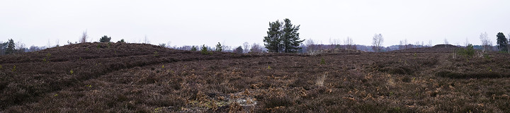
Panorama of the three main barrows on Fitzhall Heath looking North East.

Panorama of the entrance earthworks on the South Eastern side. This is the entrance/exit they would have used when popping down to Sainsburys.

Panorama from the ramparts on the Eastern side of the fort looking North.

Panorama looking North West with the track to Chanctonbury Ring across the Downs visible to the right.

Panorama of the whole site with the North Downs as a splendid backdrop.

Looking South East. Is this aligned on the Winter Solstice sunrise?

The singing ringing tree in all its festooned glory. Personally I’m not that keen on this decorating lark. Why try and beautify the already beautiful? Or am I missing something?

As noted before, the strange blue tinge that the stones take on in the shade juxtaposed with the beautiful honey tones of the lit rock.


The setting sun casting it’s long winter shadow over the barrow and the surrounding fields.


Looking North East with one of the massive curb stones highlighted in the foreground.


Looking up at the burial chamber from the lower fallen stones.

Like a scene from a battle between man and nature.... and this time man won! View from the South West (I think they were trying to rid the site of Rhododendrons, but it looks more like armageddon!)


A rough-out found among rabbit diggings. Mrs. Windsor for scale.

Looking South West along the track which eats into the side of the barrow while drunkenly swerving around it.


This is a bit of a curiosity. It’s just a couple of hundred yards south of the Burgh and maybe where the Burgh barrow gets its name from. I presumed it to be a massive dew pond (130 feet across!) when I saw it a few years ago, but apparently not so and it’s not shown as such on the OS map either. Possible explanations are a ‘siege fort’ or animal enclosure but nobody really seems to know.

Panorama of the interior ramparts near the entrance to the fort.

The view to the South is just stunning. It was so clear on this particular morning that you could make out the clump of beeches on Chantonbury Ring some 30 miles away.

Looking South along the ditch and dyke. One of the many cross-dykes you’ll encounter along the South Downs Way. This one is just before the mightily impressive Rackham Banks about 1/4 mile further West.


The trees indicate the line of the cross-dyke as it bisects the SDW footpath.

A nearby barrow with the watery meadows of Amberley scattered beneath the South Downs beyond.


Looking North West. The beer garden of the Lewes Arms eats into the side of the mound. (See fieldnotes for The Tump, Lewes for explanation/excuse).

Looking North East from the edge of the grounds around Lewes Castle.

It’s behind you! Looking south from Abinger Place.


The ditch and bank which runs down the south side of the hill. Mrs C for scale.


The Tump viewed from the ruins of the Priory.

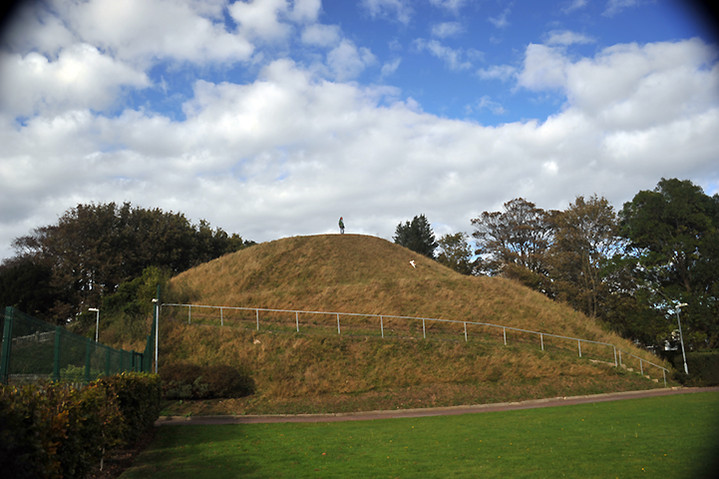

Looking North with Lewes Castle just to the left (one of three large mounds in the town centre! Read the field notes for further info.)

The view from the top overlooking the ruins of Lewes Priory in the middle distance.