
Visited 1/11/2010
In the fields at the foot of Oliver’s Castle, there is a small wild wood, with tangled undergrowth from which emerges a lively stream (carrying a surprising amount of water) at its western edge. This wood is marked on the OS map as Mother Anthony’s Well. Access to the interior was difficult, but once inside the wood,there are springs in abundance.
We had given up on finding the well in the wood and were walking around its perimeter to retrace our steps back up to Oliver’s Castle when we heard the clear sound of running water – and there it was, forming a small pool before falling into a fast flowing stream.
It is reputed to be the site of a Romano-British shrine, but archaeological finds there put its use back well into prehistoric times: flint tools from the Mesolithic and Neolithic; a Neolithic axehead and pottery fragments; Bronze age pottery and flint tools; and various objects from the Iron age, including a brooch, a ring and a whetstone.
ref: (Wiltshire and Swindon History Centre Sites and Monuments Record).
Note:
The hummocky hillock landscape on the ‘other side’ of Roundway Down has an ancient, odd feel to it – hard to describe, walking through it is recommended.


Weird and wonderful hill formations on the other side of Oliver’s Castle

Walking around the bottom of Oliver’s Castle today – these amazing hill formations.
A free day – and golden autumn sunshine beckoned …
We stopped at Rodmarton long barrow,aka Windmill Tump, on our way to a Cotswold walk around Oakridge and Bisley . The plan was to walk to three different OS marked long barrows in an attempt to see what remained of them. Before this, however, my friend, now something of a Cotswold long barrow enthusiast, had identified Rodmarton as one not yet visited.
Rodmarton was a wonderful way to kick off – the sun still low in the sky and frost on the grass when we took the turning to Trull not far from Cirencester. The barrow’s position, like most long barrows, was a joy – with views of the open farmland all around. Quite a few large trees growing on the around the edges of the barrow (a golden Beech, Oak and Ash) and evidence of some large tree stumps on the barrow. The three burial chambers are easy to identify though sadly they have collapsed in on themselves now (quite possibly due tree root damage) – just two entrance stones remain visible.
The English Heritage information board says: “A late Neolithic shrine incorporating at least three stone ‘porthole’ entrances. It was crudely excavated by antiquarians in the 19th century and its contents rifled”.
As we drove away,we were reminded we were in ‘horsey’ country when we encountered a hunt about to set off; being an ex-townie this was a first for me so I sat quietly on my emotions and observed this privileged group of people doing what they felt was their god-given right. It was gratifying to see a large deer run across the field behind them, unseen – away and free.
The walk later was golden and crisp – we passed Money Tump near Bisley; visited Seven Wells in the village of Bisley; and walked to Giant’s Stone (overgrown and unidentifiable as a long barrow) before heading back late afternoon.
Just in case they read this, a very big thank you to my friend for the transport and enthusiasm – without which this lovely day would not have happened.


Inspired by the arrival yesterday of the book “An English Countryside Explored – The Land of Lettice Sweetapple” (By Peter Fowler and Ian Blackwell) I set off this morning to do a circular walk through Piggledene over to Fyfield Down (now a designated nature reserve) and up to Devil’s Den.
As Rhiannon pointed out in her fieldnotes, the A4 is fast and dangerous at the point of entry into Piggledene. The friend I walked with today left their car in Lockeridge Road at the small village of Fyfield (SU 145685) and we walked along a footpath for about a quarter of a mile before crossing over the A4.
My first visit to Piggledene was several years ago when I was still quite new to the area; subsequently I always thought without transport or a thorough knowledge of the landscape it would be difficult to access. I have since discovered the Wilts & Dorset bus route 96 (Swindon to Pewsey) also stops on the A4 at Fyfield.
As we climbed over the stile today, it was clear nothing had changed – no fox this time as there was on my first visit though still the strong sense of time standing still. A valley of greywethers with curious sheep in the morning sunshine; venerable old hawthorns and a clear trodden path to follow around to Fyfield Down. The obvious path is on higher ground above the stony valley, it was an incredibly peaceful walk along to Devil’s Den. The knowledge that Devil’s Den dolmen never existed in its present form until the early part of the 20th century (being on the remains of a genuine neolithic long barrow) does not detract from its stony charm.
This walk with clear directions and a map is available as a Ramblers publication “12 Walks Around Marlborough” either directly or from the Swindon Tourist Information Centre.
Archaeologists are to dig out a portal tomb in Northern Ireland for the first time in 50 years.
The collapse of Tirnony Dolmen near Maghera has produced a rare opportunity to discover what lies beneath — and exactly how old it is.
Normally portal tombs, which are among the oldest built structures still standing in Northern Ireland, are off limits to excavators and must be preserved.
But after the massive capstone of this portal tomb fell to the ground earlier this year, archaeologists will be able to uncover the secrets it has held for millennia before repairs are carried out.
Tirnony Dolmen is between 5,000 and 6,000 years old, according to Northern Ireland Environment Agency (NIIEA) archaeologist Paul Logue.
“After standing in Northern Ireland weather for over 5,000 years some of the tomb’s structural stones have begun to crack, causing the capstone to slip,” he said.
“Before we start to repair the tomb we will excavate it to ensure that the archaeological material associated with it is recorded ahead of restoration work.
“When the tomb was first built it would have been used for interring the bones of selected members of the local stone age community. This could have included men and women, young and old. Finds from inside similar tombs include pottery and flint tools, possibly left as grave goods for use by the dead in the afterlife.
“We hope to find out more about how this tomb was built, when it was built and how it was used.”
Members of the public are invited to come along on Friday afternoons to find out for themselves what has been unearthed. The excavation will also be charted in a blog revealing the latest finds.
Mr Logue said the tomb was originally built by digging out a trench where the upright stones were embedded, packing round these with smaller stones before installing the massive capstone on top of them.
In recent years, the capstone, which weighs between two and a half and three tonnes, had begun to rock, putting pressure on the supporting stones beneath. These then moved, causing the capstone to slide further.
(Acknowledgements to WRAO and Digital Digging for this information)
1) “Discover Stone Tools Workshop” with Avebury archaeologist Dr Nick Stanshall
The day includes a chance to handle real stone tools from the Alexander Keiller Museum.
Sunday 24th October 10am – 4.00pm, Cost £30
2) Guided Walks through the Avebury Landscape.
Last Sunday of the month starting 31st October,
10.30am – 1.30pm Tickets: £5.00 in advance or pay on the day. Meet at Silbury Hill car park.
3) Wyrd Avebury Ghost Walks
Selected evenings in October, cost £4.75 includes a glass of mulled wine
Call 01672 539250 for details or visit
www.nationaltrust.org.uk/Avebury
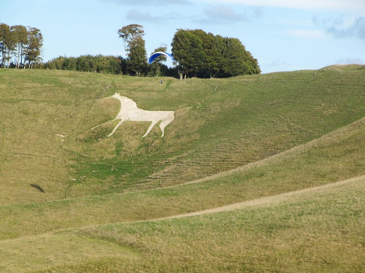
There is not much I can add to Chance’s thorough fieldnote about this hill; last Sunday (10/10/2010) out walking on Pewsey Hill and into the landscape. It hard to photograph a hill when you are actually walking on it so no photographs of the White Horse. The chilly mist lifted and the day became one of those perfect elemental Wiltshire days – a crystal clear sky and a light wind which refreshed rather than chilled. Picked Hill came into view as we made our way to Swanborough Tump (an interesting and historic spot). The most striking thing about Picked Hill is its similarity to Silbury ... or vice versa. Chance has listed all the surrounding hills so I won’t repeat them here other than to say that however you want to define the word mystical on that particular autumn day, Wiltshire was it.

I received my order from Oxbow books today of the Oxford Archaeology book “Uffington White Horse and its landscape”. Looks great; chapter 8 is specifically about Tower Hill which lies 4 km south of White Horse Hill at the northern end of the chalk ridge south of Wayland’s Smithy and the Ridgeway. It lies withing a triangle formed by three Iron age forts – Uffington Castle, Hardwell Camp and Alfred’s Castle.
“In March 1993 a local schoolteacher, Mrs Liz Philips found a dozen bronze axes and other objects while walking her dog along a farm track which ran up through a ploughed field at the northern end of the ridge known as Tower Hill ...”
She reported her find to the landowner, the Ashmolean Museum and the Wantage Museum and the site was subsequently visited by Oxfordshire County Archaeologist, Paul Smith. The hoard also includes a socketed bronze axe found by a member of the public, also in 1993 (reported to Oxfordshire County Museum Service).
Authors of the Uffington book are David Miles, Simon Palmer. Gary Lock, Chris Gosden and Anne Marie Cromarty.


Taken from D.P. Sullivan’s “Old Stones of the Cotswolds & Forest of Dean” (Reardon Publishing)
A note from Mr J.C. Wood (Transactions of the Bristol and Gloucestershire Archaeological Society vi., 1881-2 357), quoted by Crawford says ..
“The first halting place was at a remarkable monolith by the side of the highway ... This monolith is of unhewn stone, and stands 8ft above the ground, and probably is as deep beneath it. It is known as the ‘Long Stone’. No tradition conserning it remains except if it be pricked by a pin exactly at midnight, it will bleed.”
There are no visible traces of an associated mound or any other stones in the vicinity. Ray Wright quotes a source from 1857 telling of a carving of a mask on the side of the stone facing the road. I have been unable to find this piece of Victorian vandalism, but have, by photographic accident, noticed a bizarre simulacrum on the side of the stone facing towards Staunton. In the right conditions it is possible to discern the image of a human form on the surface of the stone, with arms outstretched in the manner of a crucifixion.
The Long Stone forms the important centre point of Ray Wright’s ‘Leyline Cross’, as described in Secret Forest.
(D.P. Sullivan)
To quote from D.P. Sullivan’s “Old Stones of the Cotwolds & Forest of Dean” – This monolith, of Old Red Conglomerate, stands at the side of the Gloucester to Monmouth road about a mile from Coleford in the Forest of Dean.
My very first visit to the Forest of Dean (and Symond’s Yat) today – off topic so a quick mention in passing. Just before the village of Staunton approximately 4 miles from Monmouth on the A4136 stands this 8ft monolith. Impossible to stop (or slow down) if driving towards Monmouth, my friend pulled into a lorry layby about 100 metres further along and we walked back on a narrow asphalt footpath laid down at the side of the verge. An intriguing stone much detracted from by its proximity to a fast A road.
(D.P. Sullivan has written some notes which I which type up for the Folklore section).


A friend has a double NT membership which is about to expire so we took advantage of it yesterday morning and set off for Stonehenge quite early.
What can I write about Stonehenge that hasn’t already been written ... its a fantastic ‘landscape’ with Stonehenge itself the centre of barrows scattered in every direction – seeing the landscape from the central perspective of the henge was illuminating. The stones are stately and yes, awe-inspiring; I had to resist the urge to run across the grass and touch them; the avenue is clearly visible leading up to the Heel Stone.
Starlings gathered there in great numbers – perhaps preparing for autumn (thanks for your comment Drew) always a spectacular sight to observe.
I’ve said many times before that I’m not into knocking tourists as I am one myself ... at Stonehenge, however, it is BIG BUSINESS. The site opens to the public at 9.30am – we arrived at 9.40am by 10am the car-park was almost full (lots of coach parties) with hundreds of people milling around. It is almost impossible to experience the scale and grandeur of the Stonehenge landscape in the presence of so many people ... so if you can’t make the ‘out of hours’ visit, arrive at 9.30am and you will have a better overall experience.
---------------
Edit: Just came across this, which is something I wrote on 25/8/09 in reply to Rupert Soskin’s thread on ‘the theory of blood-sports at Stanton Drew’. I add here as a very different visit to the Stonehenge complex.
I had the great treat a month or so back of being taken around the Stonehenge complex by someone called PeteG (who posted here until quite recently). We started at the spring by the river Avon where the Avenue begins, we walked through the Durrinngton Walls site (easy to imagine a village with livestock existing there), walked towards Stonehenge along the Avenue until just the top came into view with no visitors, no cars, and no road visible. It almost felt like ‘time travelling’ (I do have a vivid imagination). Then we walked over to the barrows and along the cursus. Some of it was done by car but all in all we walked a lot of ground and, as you point out in your dvd, it is an enormous site.
What came to life on that occasion was that Stonehenge was part of a community where life was lived on sorts of levels ...for me the midwinter alignments (heel stone and its missing partner) will always make the henge feel like some sort of temple as the midwinter solstice had always been the most important time of the year and why the Christians nicked it ... it was too important to leave lying around.


For anyone who lives within travelling distance of Bath, this street exhibition is well worth catching – in the square by Bath Abbey:
Sponsored by Ordinance Survey and wecommunic8.com
Wonderful arial poster-photos in wooden stands with thought provoking commentary under each display.
Uffington White Horse caught my eye (as I sat down in the sunshine to listen to a classical guitarist). There was also Abor Low; Dartmoor and Tors; Maiden Castle; the South Downs; St Kilda; the Brecon Beacons; and much, much more.
The Alexander Keiller Museum will be open to the public free of charge on Saturday 11th September, from midday to 5.00pm.

First visited on January 2nd this year. Very happy to re-visit today in late summer.


This must be one of the largest hill-forts I’ve yet seen; we walked here along the Cotswold Way from Nympsfield long barrow. Gorgeous walk on an up/down path with the steep wooded slopes of the Cotswold escarpment to our right; to our left, evidence of past quarry work had resulted in some impressive cave-like clefts in the rock face.
We had lunch sitting on the high rampart of Uley Bury overlooking the landscape to the south. A chunky white bull appeared between the ramparts, strolling purposefully along leading a small herd of young cows behind him – heading no doubt for the water trough near the entrance to the hill-fort. We walked around the ramparts only to find a larger herd of young cows congregated by the gate we needed to walk through. As we then noticed the white bull heading back in our direction we climbed onto the top of the hillfort (which is a massive open field) making our way diagonally back towards the water trough.
From here another lovely wooded walk along to Hetty Pegler’s Tump. Splendid!

The characteristic cross shape of the west, south and north chambers.

Very easy to access by car as on the site of a viewing/ picnic area on the Cotswold Way. Although there is a plantation of trees blocking the spectacular views over the Severn Valley from the actual barrow, the views a few metres along make this a very satisfying place to visit.
Rather manicured and to be honest somewhat soulless, this is my second visit. This time, however, I was struck by the characteristic cross shape of the chambers – the entrance facing east, with north, south and west chambers visible from the top of the barrow.
From here we headed to Uley Bury hillfort and Hetty Pegler’s Tump along the Cotswold Way.

Glimpses of the harvested fields through the trees from the barrow


A beautiful late summer day and a walk planned along the Cotswold Way from Nympsfield long barrow to Uley Bury Hillfort then on to Hetty Pegler’s Tump.
My friend (the amazing map-reading M) picked me up at the usual place in Cricklade and away we went, heading in the direction of Malmesbury. M had a little surprise tucked away; en route we went through the little village of Leighterton, deep in the rural Cotswolds; M had been studying OS Explorer 168 and spotted a long barrow just past the village school along Boxwell Road.
This is an enormous barrow and easily visible from the road; we parked in a little pull-in and donned walking boots – although on private land we were definitely up for a clamber over the three Cotswold stone walls that were between us and the barrow. Be warned about these walls though, especially the road side one – a low wide wall with a much higher drop into the next field; not really a problem until we returned.
The barrow is magnificent, reminiscent of the East Kennett Long Barrow it is a similar size – 80 metres and 6 metres high. Although it didn’t appear to be on high ground there was tantalizing glimpses of harvested bales spreading out to the south of the barrow. The barrow itself is surrounded by an old Cotswold stone wall which is relatively easy to climb so we did … it is completely covered with ivy and trees (either sycamores or field maples). Clues to long past excavation in the dips where there was once possibly an entrance to the barrow, however, this is no longer in evidence.
A few scrapes and scratches to show for this one, but so well worth it.

The view from Harefield hillfort towards the River Severn

Walked here today after spending a couple of hours in Randwick Woods looking for the Randwick long barrow. It really was a case of coming out of the shade into the light. After being in woodland the afternoon dazzled; not much to add to thesweetcheat’s excellent fieldnotes other than to comment on the spectacular views, especially looking towards the River Severn.
I also noted that, as with the Wiltshire hillforts, this one appears to be chalkland – odd in the limestone landscape.

Hard to find but identified by use of OS Explorer 179 and its east/west alignment.

