
Best seen in summer when the reservoir level is low.
Image credit: ryaner
Best seen in summer when the reservoir level is low.

Reservoir-side bullaun that gets almost inundated in winter.


Just west of an ancient church site, on the brow of a small hillock.

The basin on this is cut into the slope of the stone with one steep ‘side’ and one shallow.

What do we do when an earthfast cup-marked stone, flush with the ground, is starting to be swallowed up?
Said to be a ring barrow, I guess that’s as good a name as any. Herity says that “The form of this site is similar to that described in the OS Letters as the ‘Rath of Cumhal”, giving the nearby town its name, Rathcoole (old Fionn again).
It’s on the southern slope of Windmill Hill, about 300 metres down from the road. The overall diameter is 80 metres, with the internal flattened mound about 30 metres across. Both fosses are better preserved on the south-eastern quadrant, the two almost a metre and a half deep.
I’ve seen double- (and triple-) ramparted raths before, but never a double-ditched barrow. It’s a thing of structural beauty, slightly spoiled by the nearby pylon and truncated on its western arc.
I had parked badly here and may have come the attention of the locals so I was a tad uncomfortable and didn’t stick around to fully appreciate this site. Still, another Dublin (the Kildare border is about 200 metres away) monument that I’d only heard about very recently – and one of substance at that.
Boherboy, from the Irish Bóthar Buí – yellow (maybe gold) road, has this stone pair that I pass regularly. Lily-Mae and myself stopped by today after having visited the barrow in Newtown Lower. The grass hadn’t been cut nor grazed in a while, leaving a golden brown meadow for Adam and Eve (yeah, I know) to bask in.
The male pointed stone is about 1.3 metres tall, the blocky female slightly taller. They’re aligned roughly east-west. They suit each other and one cannot imagine them separate.
The landowner showed up while we were here and was extremely friendly – these semi-urban stones are visited regularly and I had expected that he may well be pissed off with the damage to the gate, but no. He was here to see if it was worth cutting the grass for winter feed.
This monument is one I take for granted but I appreciated its beauty much more today.


The outer ring of the western edge is cut into by a field boundary.


One of two known stones that have cupmarks in Downshill townland. This is the easier to find, over the hedge from the road. However, if approaching from the north, enter the next field to its north and walk to the the gate about 100 metres down.
There are 8 worn cupmarks along the highest ridge of this metre long stone. The Sugar Loaf just peeps over the horizon line to the north. There are said to be more cups down the south-east side of the stone but I didn’t make them out.
The other stone lies almost due east of here, but as the farmer was working with heavy machinery nearby I didn’t try to find it.
These two stones, one single and portable and one a triple bullaun, are in the isolated townland of Ballard, above the Avonmore River and north-west of the peak of Trooperstown Hill. The single bullaun stone has been damaged some time ago but is a little gem in itself, a Wicklow granite stone with a weathered brown look.
The triple bullaun, a glacial erratic, is thought to be in its original location, now incorporated into the wall at the gable end of a cottage. It’s quite a tall stone, well over a metre when you stand on the road, and the bowls are not immediately apparent as you stroll by.
On the day I visited all three were holding water, one with some type of seed floating within, all three quite magical in their beauty and simplicity. Two are set quite close to each other to the south, with a natural channel connecting them – the other, the largest, is the one with the seeds in the photo.
Quite a journey to get to if approached from the Annamoe to Laragh road, through the forestry tracks and all, but very well worth a visit. I did knock at the cottage but there was nobody home at the time.


Only re-discovered when the hedge here was cut back about 8 years ago.

The third bowl on the large boulder is 28cms in diameter.

The large stone in the wall has the 3 bowls on its top surface, the single bullaun lies beside the road.


Ye olde water on the stone trick lifts the cupmarks a bit. There are 8 along the ridge.

Looking north over the stone, the peak of the Great Sugar Loaf peeps over the horizon.

Looking west at the Great Sugar Loaf from the N11 slip road at Kilmacanogue – one of the cairns at Glencap Commons Upper can be made out on the spur to the north of the peak.

Tiny cairn in the foreground on the summit of the hill. Howth can be seen in the distance through the gap between Monpellier Hill to the left and Kilakee mountain. I’d never noticed this before but it is a prominent feature on the summit of the hill. (This shot was taken on an iphone so it doesn’t show up too well)

Site H revealed. Yet another fire on Piperstown Hill has revealed quite a substantial cairn, probably the biggest of the 10 or more here. The kerbstones on the south side, nearest the camera, are large.
New tests on the remains of a preserved body found in a Co Laois bog have revealed that it is the oldest bog body ever discovered in the world.
The body was found by a Bord na Móna worker milling peat in 2011.
It was initially believed that the remains were those of a young female which were around 2,500 years old.
However, a series of recent tests have revealed that it is the body of a male, which dates back as far as 2000 BC.
More here:
I had never even heard a whisper of this site until today, when, as I was going to visit a friend in nearby Delgany, I poked around on archaeology.ie and low and behold, there it was. Giltspur, from the Irish Giolspar, has a cup-marked stone, “…18 weathered cup marks are scattered across the highest point…“.
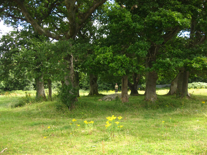
After looking at the satellite shot and the OS map and noticing there was a discrepancy between the two, with large buildings showing up on the latter and not the former, I didn’t think that it would be an easy find. There was another site right on top of it – a so-called “designed landscape”, “possibly a tree-ring”. Never heard of one of them either. Anyway, sure it was worth a look.
So off we set, turning off the N11 at the first Greystones exit, turning right at the first roundabout and then the 4th exit at the second, into the retail complex (the new buildings on the OS map) and a hard left into the delivery entrance, around the bend and into the car park. This little slip road points directly at the monument – we just had to ascend the very steep, man-made scree slope, 40 feet up and then over a fence.
And then there it was, not 100 feet into the field. Could it really be that easy? The earthfast stone, nearly 3 metres square and standing proud of the ground by about half a metre and sloping eastwards to disappear underground, is at the centre of that designed landscape, a very henge-like ring. The cups are very worn, almost completely weathered away, with only 3 really visible (I didn’t bring water with me, but given previous experience I’d say the panel would come out with a bit of the old side-flash).
The ring itself is strange, almost 20 metres diameter, with traces of a ditch on its outside, and deliberately planted with oak trees. Inside the ring, beside the stone, there is a block of red quartz. There are also the remains of a campfire and the usual discarded beer bottles and cans.
The views from the stone would be extensive, were they not blocked by the ring trees and other plantations further out, many hills that have prehistoric remains being visible.
I mentioned to my friend that we had been here on the way to her place. Oh Giltspur, she said, that’s well known around here – it’s the old name for the Little Sugar Loaf mountain (on which the site lies). After I told her of the signs of partying at the site she mentioned the presence of white witches around there. Ah bless.
So, a cup-marked stone inside an embanked ring that has been planted with oak trees. Archaeological monitoring nearby “did not reveal anything of archaeological significance”, so maybe the ring is modern, possibly thrown up and planted by the previous land-owners. Who knows?
I didn’t expect much here today, and I wasn’t disappointed. This poor battered stone now rests on 3 stones, held there with mortar, and used as a flowerpot. It’s in the grounds of Kilcoole church where it’s been since it was rescued by the parish priest over 50 years ago. Liam Price’s notes from 1959, shown here, tell the sad tale.
This is worth quoting in full.
From the Liam Price notebooks: the placenames, antiquities and topography of County Wicklow.
Edited by Christiaan Corlett and Mairéad Weaver
Department of the Arts, Heritage and the Gaeltacht:
Recorded by Price in this notebook, dated 4th May 1959, as follows; ‘Patrick Healy told me that a bullaun stone had been found near Kilquade Church and had been brought to the church by Father Masterson, the parish priest. I went to see it today. It is at the E side of the church, placed on the stump of a large tree. It is a very curious stone, a block of granite about 3ft. 3 in. by 2 ft. 3in. [which] has three hollows or basins, much broken, on the one side and a large oval hollow on the opposite side. The large hollow has been placed mouth downwards on the stump, so it is not easy to measure: but it appeared to be (approximately) 23in. by 13in. and 9in. deep, with a hollow worn or ground smooth. On top there are three hollows, all broken on the outer edges: (a) three quarters complete: 12in. x 10in. and 11in. deep: it is the end of the longer axis that is broken away, so the 12in. is an estimate. (2) about half remaining: 8in. deep and it was probably about 10in. in diameter. (3) very much broken away: it was probably about 10in. in diameter: I could not measure the depth. [drawing] This is a rough drawing of the top of this tone with the large oval hollow indicated underneath. The edges of the stone have been broken away, it would seem with a sledgehammer; they are not worn away by weather. The hollows of the three basins are smoothly and evenly rounded.’ (Corlett and Weaver 2002, 644-5).


Badly damaged triple bullaun stone, now turned upside-down and used as a flowerpot in Kilcoole church grounds.

The stone, in its upside-down state, with one of the bowls coming in handy as a receptacle for the modern upright. There’s another damaged bowl to the left.


There are said to be 18 cups on the top part of this stone.


Two bullaun stones within 50 metres of each other at Sroughan. Both formerly earthfast and pushed to one side, the first can be seen from the road, the second a little trickier to spot. Coming from Kilbride, after the left turn for Carrig (with its numerous megalithics, including a wedge tomb) the road veers to the left in an easterly direction as it heads towards Lacken. Immediately the road straightens out, the view over Blessington lake opens up and the two stones are in this first field on your right.
Down the hill in a corner is the first stone, a granite boulder a little over a metre cubed with some damage to it. The shallow basin is on top and is pretty forgettable in comparison to some of the stones in the vicinity.
The second stone is in a hedgerow in the next field down. It took quite a while to find and after a discouraging bang from the electric fence in the field (I assumed there would be no current as there was no livestock in the fields – bad mistake). It’s very overgrown with brambles and particularly vicious rose-hips. The stone seems to have been damaged when it was dug up – about a metre and a half long by a half a metre wide, with the large, more interesting, basin at the more hidden end. I didn’t feel up to doing battle with the plant-life so I’ll have to come back in the winter and see if I can get a better view of the stone and its basin.
Here’s a hint when going bullaun stone hunting in the summer – don’t wear shorts. Even though it looks from the map that the stone is easy to find, by the time you get to the bottom of the field, through the barbed wire fence, by the nettles, over the brambles and into the dry stream bed, you may not have any legs left, and what you do retain will be bitten to bits by little bastard bugs.
The Ballyknockan Wart Hole hasn’t been visited in quite a while, at least 10 years I’d say. We approached the site coming from Valleymount, through Ballyknockan itself, and on to the parking spot north-east of the village. If you look along the entrance to the parking spot in a straight line, the stone is directly in front of you about 400 metres down through 2 fields. However, there is an easier way – walk back towards the village to the next field on your right, climb the gate and go to the very bottom of this. There’s a barbed wire fence here and it’s overgrown behind it. The field boundary continues here and over that is a stream. About 40 metres further behind the fence is the stone.
When we did eventually find the granite stone it was overgrown with moss and brambles, and the basin was full. After a quick tidy up the large oval basin was revealed. The water and detritus in this stank to high heaven. I reckon it would cure more than just warts. It felt good to find this, a kind of triumph, as nobody else seems very interested in it and it’s in danger of being completely forgotten.
