
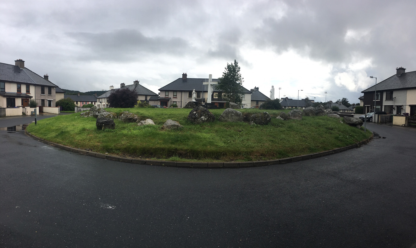
In Cloch Choirneal (corner stone?) housing estate, a stone in the corner of a field still stands.
Image credit: ryaner
In Cloch Choirneal (corner stone?) housing estate, a stone in the corner of a field still stands.


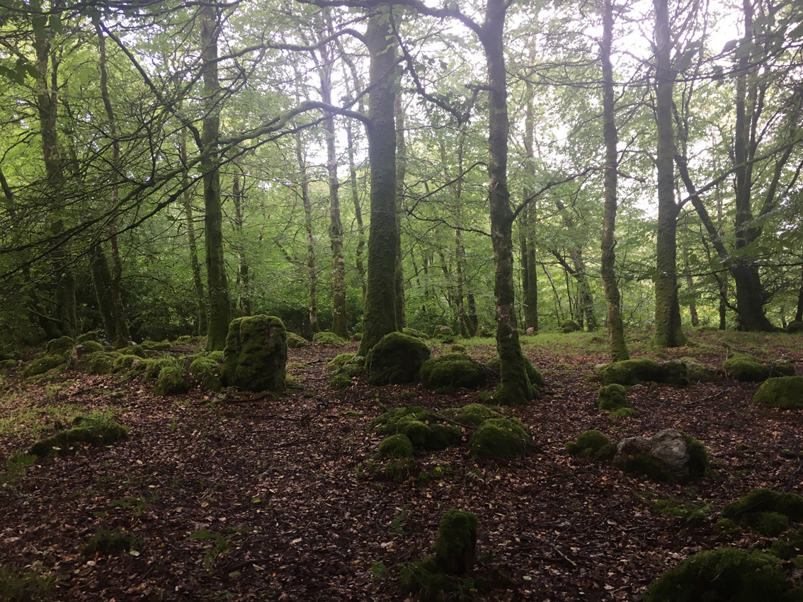
Possible court stones in the foreground, with unset chamber stones in the background.

I’ve seen many arrangements like this in many forests all over Ireland, and ignored them.

Over the entrance lintel into the oval-shaped court. Creevykeel is phenomenal, if a tad sterile, and it’s hard to have it to yourself. Moneylahan is only up the road.

Another view of best preserved of the three subsidiary chambers at the back of the cairn.

Subsidiary chamber at the back (south-west) of the cairn.


Looking north over the southern corner of the facade. The double-walling on the southern side of the tomb has mostly been robbed out.

Looking front-on at the facade. There were probably 4 stones in the facade originally. One is missing and the one on the right has collapsed under the weight of the roofstone. Behind the facade, the chamber has been filled in with grass covered rubble.

Looking down on the chamber from the double-walling on the northern side. Behind the sycamore that s growing in the chamber is a backstone that has been incorporated into a field fence.

Looking south along the tomb facade. The fallen stone is a facade stone, pushed out by by a probable portico roofstone.

Superb double-walling on the northern side of the tomb, looking west from the rear.

The remaining roofstone from the chamber has slipped off the northern sidestones and now rests in the chamber and across 3 southern sidestones.

The eastern entrance jambstone of the north-east gallery has split in two. The sidestone to its right is about 3 metres long.

Looking south-west out of the south-west court. Benbulbin shapes up in the distance.


Similar shot of the SW gallery but this time showing the extent of the cairn, said to be originall rectangle in shape and 19 metres wide. Twelve metres separate the two back-to-back galleries.

Over the NE gallery. The low hill in the near distance holds a fantastic cashel that’s also worth a look if you should venture here.

Another view of the NE gallery. Though the site is damaged, most of the original stones are still here.

This is the north-east gallery. It too is double chambered. The entrance jambs are a mismatched pair. The large stone to the rear right seems to be a displaced roofstone from the back chamber, now resting on the gallery backstone.


The SW chamber is left of the shot, segmenting jambs obvious with low entrance jambs about 2.5 metres in front of them, the rounded backstone is a further 2.3 metres behind them.


Benwiskin towers over the court tomb at Moneylahan. The back-to-back dual-court tomb sits in a cairn 45 metres long. It is now officially my new favourite site ever.

From inside the western gallery, east across the court to the side-by-side eastern galleries. Again, the stone just outside the jambstones in the foreground is a possible fallen lintel.


Looking north at the back of the western tomb. The stone leaning against the backstone might be a roofstone.

Over the eastern gallery entrances towards Keelogyboy Mountain.


The south-east gallery. The stone immediately inside the entrance jambstones is a possible fallen lintel. The fallen stone behind it is a possible segmenting jambstone.


From the back of the south-east gallery. Its backstone is the stone nearest right in this view. The north-east gallery runs parallel and has the gravity-defying lintel over its two entrance jambstones.
A huge Iron Age roundhouse, thought to be about 2,500 years old, and roman pottery have been uncovered during an archaeological dig at a coastal fort.
Volunteers have joined experts to find out more about the little-known Dinas Dinlle National Trust-owned monument in Gwynedd before it falls into the sea.
The 43ft (13m) wide roundhouse was buried by coastal sand, thought to have blown there during a sandstorm in 1330.
Coins found at the fort near Caernarfon suggest it was occupied in Roman times.
The “well-preserved” roundhouse – with its 8ft (2.5m) thick walls – was uncovered close to the cliff edge buried underneath 3ft (1m) of sand during a two-week dig.

A christianised Carrowmore-style passage tomb on a roundabout in a local authority housing estate.
From archaeology.ie
Class: Megalithic tomb – passage tomb
Townland: UNION
Scheduled for inclusion in the next revision of the RMP: Yes
Description: Sited alongside a trackway in extensive woodland in a gap in the Ox Mountains 0.7km NW of Ballygawley Lough. There are a number of mature deciduous trees on the site and the stumps of others. To N and W the ground drops quite sharply to a stream that flows NW-SE. Trees inhibit the outlook from the site but Maeve’s cairn on Knocknarea is visible to the NNW. A ring of boulders (19.5m N-S, 17.5m E-W) encompasses a slight platform. There are a number of gaps in the ring of boulders but the indications are that they were contiguously placed. Among the numerous gaps are two that may be original features, one at the SE (Wth 1.3m) and another at the NW (Wth 1.1m). A number of prostrate boulders outside the perimeter may be displaced. Some of the boulders encircling the platform are quite sizeable (the largest is 0.95m x 0.85m x 1.15m high) but others are noticeably smaller. The tops of at least three stones are visible about 3m inside the perimeter at the W. The status of these is quite unclear but their presence suggests that there may have been an inner ring of stones. Somewhat to the W of the centre of the enclosed area four stones lie prostrate. The larger two are about 1.6m and 1.4m in maximum dimensions. These may represent some form of internal feature. The nature of the site is somewhat uncertain but it may be a Carrowmore-type passage tomb. It is indicated as a small oval field on the 1913 OS 6-inch map. Some 100m to the W there is another possible passage tomb (SL020-275----).
The above description is derived from the published ‘Archaeological Inventory of County Sligo’ compiled by Ursula Egan, Elizabeth Byrne, Mary Sleeman with Sheila Ronan and Connie Murphy (Dublin Stationery Office, 2005).
Date of upload: 18 January 2008


By a forest track at the foot of Slieve Dargan.


Kerbstones, and a peculiar orthostat, on the north arc of the cairn.


On top of the second cairn, with the lake and the passage grave in the distance.

Freedom at the Cailleach’s lough on top of Slieve Gullion, a week after the passing of my mother.