


From this angle, the top stone looks as if it could fall at any moment


I thought to myself that the standing stone in the townland of Clogh just had to be impressive. Alas, there’s just this wee beastie, a little over a metre high.

“Excavated by Conwell” (around 1865 I think), this was possibly the first one he tackled given the state he left it in. Aligns onto Cairn T.


The one remaining stone of Cairn X3, with a stone from X2 at top right and X1 to the left

A modern-looking bullaun in one of the centre stones of CairnX2
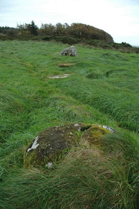
The four remaining (uncovered) stones align quite nicely

Cairn X1 to the left with Carnbane east and Cairn T dominant in the distance


A very feint cup-mark and some very feint lines show up in this shot

There are 2 possible routes to the cairns on Patrickstown Hill. You could climb Carnbane East and head across from there; or you could do what I did and park at N604783 on the east side of the hill and follow the faint track that starts behind the gate opposite the parking spot.
This track leads around in an arc on the south side of the hill. It starts to dip a bit but then rises once more on the south-west side, terminating in the small meadow that holds the three X cairns.
Having seen the drawing posted here my expectations were high. What a pity then to find the stone almost completely eroded, with only very faint markings and a jumble of various lichen further obscuring the matter. Cairn X1 may have been glorious once upon a time, but those days are long gone. Of the three here it still has quite a bit of kerbing left and is structurally the most cairn-like.
I could only find 4 stones of Cairn X2 and there is no visible mound to suggest a cairn. One of the stones in the centre of the putative cairn has a bullaun but this looks to be of a more recent vintage.
Cairn X3, of which it is said that two stones remain, has only one visible, and not much else to write home about.
You may wish to head up to the summit to search out Cairn Y. Make sure you have good footwear and a ton of patience: the heather and brambles are waist high and the ground, in late October, was extremely boggy. I did a cursory search and found bupkis.
The one happy thing to report from this site are that the views across to Carnbane east, with Cairn T as dominant as ever, are magnificent.


Item no. 295 of the Arch. Inventory of Co. Meath, this is said to be a “standing stone with about thirty cup-marks.” The stone is very like a kerbstone, about a metre high and 2 metres long and it is possible that it comes from a local passage grave. I counted 54 cup-marks, though not very scientifically.
The site is a very well looked after graveyard in the drumlins south and below Sliabh na Cailí. I couldn’t help but speculate that the mound that the graveyard is sited on is a passage grave that has been christianised and that this is where the stone comes from. There are some very rough-hewn gravestones that look suspiciously like the structural stones of a megalithic tomb.
Across the road is a holy well with some lovely sweet water.


Cairn L, Carnbane west is aligned on Cairn T, Carnbane east, seen in the distance to the right


Cruciform chamber of cairn F, a tad overgrown at the end of summer ‘06

Don’t know much about these sites, but this seems to be a fine specimen. Shot was taken from the road.

Tornant Lower ringfort/rath, taken from the west end of the ridge that contains Tornant Upper passage grave.


Possible kerbstones at this site. The tomb is to the left, out of this shot.

The tomb is the gorse covered mound in the near distance.
Arch. Inventory of Co. Wicklow has it that this is a possible passage tomb. Also says that a decorated stone now in the National Museum of Ireland is reputed to have come from here.
The mound itself is completely overgrown with gorse. There are a few outlying stones to the north of the site that may be part of the kerb. On the south side there is one large boulder that could be some possible kerbing too.
I clomped through the gorse to a clear area on top of the mound but there are no signs of any opening into the tomb here.
The views across to Keadeen and Lugnaquilla are amazing.


The ogham script is reasonably clear in this shot.

Brittas IV with Brittas III just visible in the undergrowth in the background.

The bullaun, looking back towards the road. The little stream is just 1 metre in front of it.

Another view of this amazing stone. The little brook has spilled over and filled the bullauns with water.

6 bullauns in total, 4 singles and one double with one part of the double elliptical

Known locally as the hand print of St. Lawrence O’Toole
I searched high and low for the bullaun that’s marked on the OS map at S977949 but to no avail. I was about to give up when I noticed a beaten track leading from the forestry entrance where I had parked. I followed this and it led me out of the forestry and into the field where the bullaun is marked. Continuing along this I crossed the stream and BAM, Brittas 4 with its four single and one double bullaun was there in front of me. I can safely say that this came as a total shock and a surprise to me. Continuing further up the track about 10 metres further on is Brittas 3 with its four bullauns.
Both of these stones are earthfast. They sit there for all the world like magical vessels as the small brook bubbles nearby. Seems there’s a lot more to this place than what first meets the eye. According to the Arch. Inventory of Co. Wicklow there’s “a large, earthfast granite boulder with four basins…” which I take to be what I have called Brittas 3. With the two that Fourwinds has added, thats four bullauns with 50 metres of each other. Awesome!
In a garden just off the N81 at Ballintruer More is this charming stone. It’s well marked on the map and well looked after by the folks that own the house.

The tall stone to the right is the standing stone

The stone is to the right of the speed limit sign


