
The roughly shaped axial stone, higher than its immediate neighbours.
Image credit: gjrk
The roughly shaped axial stone, higher than its immediate neighbours.

The easternmost remaining stone, with the two portals leading into the background.

The inside of the portals, taken while sheltering from the strong sun behind the axial stone.

The axial stone rising behind the beautiful quartz boulder and some jaded nettles.


In which I drink my fill of quartz and my thirst is sated.

Looking towards the stones from a distance of about 45 feet.

The western chamber. Inside the Tent of the Presence.

Looking down the field towards Snowdonia. Credit to postman for a more awesome view.

Looking roughly northwest at a veritable cake of quartz.

The western chamber with light spilling in from the false entrance.

Looking through the portals along the axis to Burl’s ‘gunsight’. The shapes and relative positions of these two pairs of stones mimic each other, the southernmost one of each coming in at an angle to its more vertical partner. It’s tempting to imagine a nod here towards the arcing dip of a setting sun, and an observation or celebration both inside and outside the great circle.

Cloghavilla with the Great Stone Circle to the northwest.

Looking east over the double walling of the south face of the tomb.

The fallen capstone at the entrance of the tomb helps to form an interesting megalithic chest.

The split in the northern portal leading across to the eastern curve of the perimeter.

The massive portals at the northeast of the circle.

Looking southwest across the circle with the russet rear of Rannnach Croim Dubh filling the right hand side of the picture.

In the tradition of ‘stones that look like something else’...
The Eagle of Grange.

The tomb interior, past the overlapping orthostats of the north-facing side.

The southern section of the entrance kerb with the quartz boulder on the southwestern corner.


The eastern side of the ditch, showing what may be some of the stone facing of the outer wall mentioned by Anthony Weir.

Two quartz mini-boulders, in a diagonal from the foreground over the odd looking clump of grass to the middle line of the picture. While these may be dumped from the field, there isn’t a huge amount of debris thrown in here and they are both in and around the pit gouged out of the centre.

A view northeast over the presumed axial stone and through the portals. rjck, while deeply involved with the survey here, still found time to step into the one wet cowshit in the field before we left.

The horizon on the axial line southwest, showing a gap in the mountains which could have been the focus. Its difficult to be sure because of the ruined condition of the portals and axial stone.

A view southwest through what is most probably the portals, one standing and one fallen, over what would then be the prostrate axial stone.

Glantane, no longer ‘for sale’, sits in its saucer on the edge of the world.


Looking at the horizon to the southwest along the axis, if the missing stone was to the northeast, or the left foreground.
Sorry about the picture clarity. It’s been a dull day.


From the field that brought you cows.
A basic site plan altered to show an arc of possible positions for the fourth stone, which would probably have been located at the east of the conjectured circle. A position here would keep all stones with their long axes parallel to, and paired on either side of, a line running northeast to southwest.

Gortnacowly, referred to evocatively in the 1899 trace for the 1902 O.S. Name Book, as “four standing stones of druidical antiquity”.
I’ve altered the plan to show an arc of possible positions for the absent stone which would probably have been located on the eastern side south of an axis line running northeast to southwest.

The arrow points to the location of the circle, just in from the edge of that section of undergrowth.


Drawn from O’Nuallain PRIA 84 C (1984).

Modified slightly from E.M. Fahy JCHAS 1959.
Declination figure taken from Clive Ruggles’ ‘Astronomy In Prehistoric Britain and Ireland’ 1999.
All five pits were found sealed under a gravel pavement. The fallen stone was re-erected after excavation and marker pillars placed in the two empty sockets. Slabs were positioned over the locations of the human remains.


All pictures were taken in October 2004. This is the axial taken from a couple of metres in front of the circle.

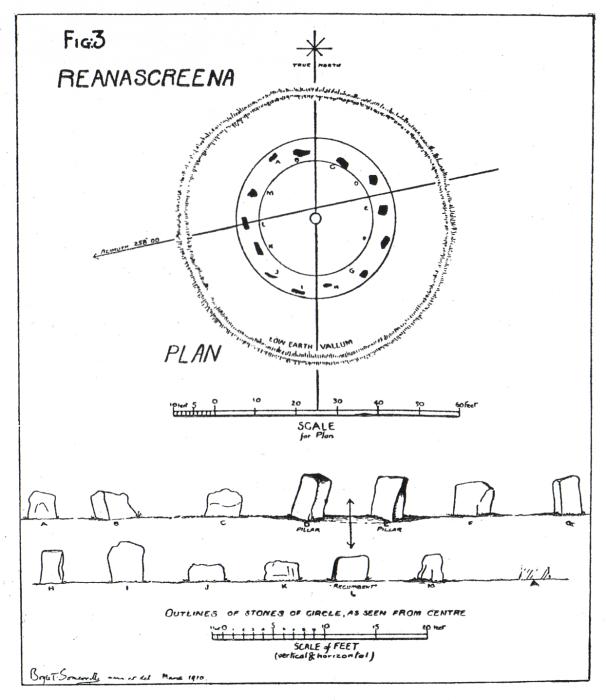


Taken from JCHAS No.35 1930.
Somerville died in 1936, murdered by a group of local eejits because he encouraged young lads to join the Royal Navy.

Looking southwest. Carrigfadda is the taller hill to the rear. Maulatanvally is to the left.


