
Access: Right next to road, I think I pulled a couple of wheels onto the verge so that vehicles could get past.
In the far north of Jutland, near the north edge of Limforden, close to Fjerritslev and Gundestup, fairly near Aalbog. Take the 11/29 between Aalborg in the east and Thisted in the west, heading for Fjerritslev.
About 10km east of Fjerritslev, at Skovsgård take the turning south towards Attrup. After around 2km, at Torsley, turn right and after just under 3km, take a left just before a large barrow on the right. This will take you to the monument which will be on you right after a few hundred metres.
Visited 6 April 2006
Excellent! A smallish but fascinating multi-chambered passage grave. I’d seen a few that I’d not been able to get into that had at least one chamber ‘behind’ the main chamber, but none that I could get into. (See Suldrup for example.)
It’s a shame that the restoration of the barrow hasn’t been more ‘sympathetic’, as it contains a lot of incredibly intrusive modern metal supports. Mind you, at least it means the thing’s still standing and you can even get in – with a bit of a squeeze, and once in it’s a crouched waddle around....!
As well as this one, there are tons of barrows in this area. There are few in the fields to the NE & NW, and a couple by the road immediately to the north.
There is a particularly striking one on high ground to the south, which you can see clearly from Hvisselhøj. It may even be within sight of Limfjord, a little further to the south. Gunderstrup is also very close.
Unfortunately, I had a few more things I really wanted to see (including Gunderstrup) and a long way to drive back to Fyn, so no time left to investigate ‘possibles’.


7 April 2006 Jane inspects ‘suspect’ cupmarks on capstone

7 April The ruined dyssekammer (chamber without passage) with partially & drastically canibalised capstone – as well as big square section ‘missing’, note chunk cut off on right
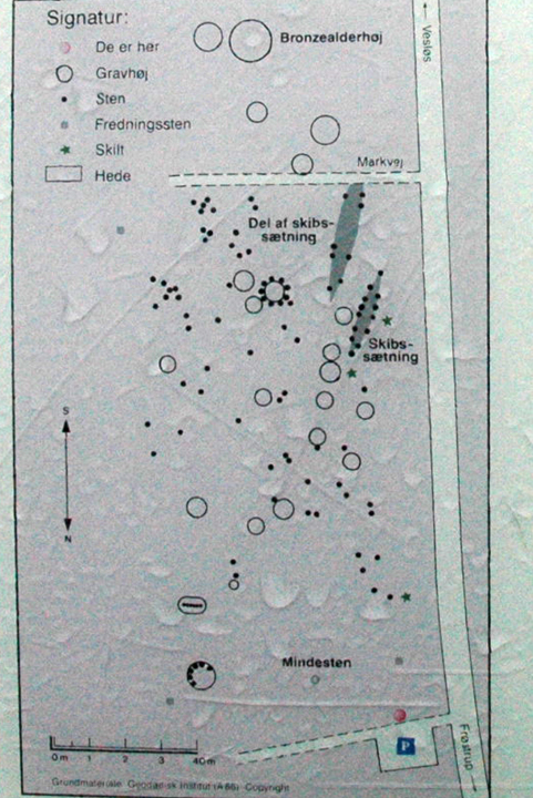
6 April 2006 Plan of site from info board – print it out & take it with you – I had difficulty working out what was what!
Access: Carpark right next to road. The graves are immediately next to the carpark. Walk of 100 hundred metres or so across heathland.
In far north of Jutland on road between Tømmerby and the 29/11 between Thisted and Fjerritslev.
From the east, soon after a section of the 29/11 follows the edge of the Limfjorden fjord, there is a right towards Tømmerby at Øslos. I took this but it was more complicated than it looks! So I’d recommend keeping on the main road until Vesløs and turning right (north) there – I cam back that way and it was far simpler.
This is actually the road that the cemetery is on. Follow it north for about 3km and keep an eye out on the right (east) for the the stones of the cemetery and its little carpark.
Visited 6 April 2006
Hmm. Lindholm Høje it ain’t! It’s far less extensive and far harder to work out what’s going on.
I wasn’t able to explore terribly well due to weather, time-constraints and, frankly, fatigue. This was the last site on a very long and very wet day with a lot of mileage, so I feel my visit probably didn’t do it justice!
It didn’t help that commendably, the info board is a fair bit away from the graves – meaning I found it difficult to relate the plan of the site to what I could see on the ground.
This was important because, at least when I visited, the site was quite overgrown with scrub – which is as different as you can get from Lindholm Høje – more natural, but much harder to navigate.
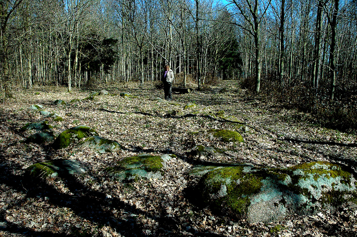
It’s also different from Lindholm Høje in that many of the memorials are single stones, as well as a lot of more distinctly Viking longboat settings and small barrows.
Definitely worth a visit though if you are in this part of Denmark or if you can’t make it to Lindholm Høje.

6 April 2006 Many single-stone graves


7 April 2006 First view approaching from path through woods from carpark
Approximate long/lat coordinates, as I couldn’t be sure I could see the dolmen in the fieldborder on the aerial photomap. Shouldn’t be too far out though and, if anything may be a few metres closer to the farm.
Access: Walk of something like 300 metres along reasonably even field edge. (First few metres were across ploughed field when we visited.)
Very near Kong Humble’s Grav. From the 9, at the eastern edge of Rudkøbbing take the 305 south for about 11km. Not far after passing through Lindelse, the road distinctly zig-zags through a small village, probably Bogetofte or the outskirts of Kædeby. Just after the zig-zag, there is a turning on the right (west) into Kædeby village.
Take this turn and continue on this road for about 0.5km. Look out for a farm entrance on the left (south) with a (telecoms?) tower. Park here and walk around left (east) side of buildings. It may be worth asking at the farm first, but there seemed nobody about for our visit.
You will find a tiny paddocklike field with a tree-ed area to the west. Go to the corner of this diagonally opposite and you will reach a very far large field.
From here you should just about be able to make out the dolmen in the field boundary to the SW, quite far ahead on your right. Cross to this field boundary (there was a slight path when we visited) and walk along to the dolmen.
Visited 7 April 2006
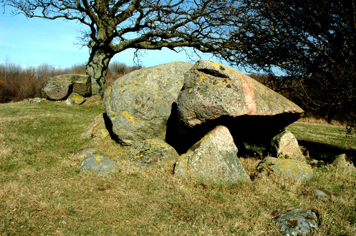
Wow! A spectacular dolmen in the mould of Cornish examples like Mulfra or even Trethevy.
Unfortunately this is another one I’ve not been able to find any info on. And because it just sits in a narrow overgrown bit of field boundary between well-cultivated fields, it’s very difficult to make anything out on the ground.
Lovely big chamber though, with a huge allegedly cupmarked capstone. Not sure about the the authenticity of the cups, but enjoyed our bonus deer! (See photos.)

7 April 2006 Farm entrance with tower for orientation in finding dolmen

7 April 2006 Possible cupmarks – I’m no expert, but I’m unconvinced


7 April 2006 Difficult to inspect the chamber properly from the ‘front’ (east) because of nasty whippy branches

7 April 2006 Phwoar!!! (Looking roughly NE)

7 April 2006 Approaching from north along field boundary – deer to south cannot be guaranteed
7 April 2006 From roughly south – jættestue (passage grave) chamber in foreground with wrecked dyssekammer (passageless chamber) in background

7 April 2006 From roughly west – jættestue (passage grave)


7 April 2006 From roughly east – jættestue (passage grave) – passage stones in forground


7 April 2006 First view of monument approaching on road from south
Access: Short walk of less than 50 metres gently uphill over grass. Park at edge of road.
Kong Renes høj, as it is also known, is very near other monuments in the woods near Frellesvig on Langeland. For full directions see Ringlehøj i Snave Skov.
From Ringlehøj i Snave Skov, head east, back out of the woods and take the first left turn, north along Pæregårdsvej. As you enter the woods, you may glimpse a barrow on your left through the trees. (Actually, I seem to remember that it’s on a bend and is initially right in front of you.)
This is Gravhøje i Pæregård Skov, which we didn’t stop at – it seems as though it’s probably ‘just’ a mound – of course I now wish we’d had a quick look!
Continue through the woods, and after just over 0.5km you will emerge into fields. The road winds along to the monument just under 1.5km ahead, on the left (north) of the road just before re-entering trees.
Visited 7 April 2006
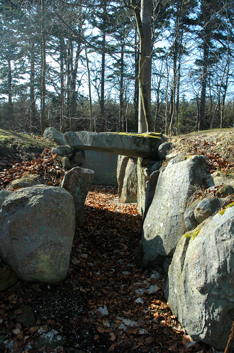
In a pretty rolling area of cultivated land in the middle of woodland stand 2 chambers on a large mound, along with a couple of trees.
The southern one is a passage grave (jættestue) dating from 3,500-3,100bc and the other a (very ruined) passageless chamber added around 3,000bc.
The latter has been brutally butchered – its capstone has big chunks cut from it. The edges of these cuts are so straight that they speak of (at least relatively) recent damage. And as if to emphasise the damage, at least one piece cut from the largest piece is still right beside it.
Despite the frankly shocking state of this northern chamber, the monument retains an impressive majesty – certainly living up to its billing as “King Rene’s hill”.

7 April 2006 From road to north – impressive kerbstones protruding from overgrown langdysse
7 April 2006 View from north chamber along to south


7 April 2006 The reward as you round the monument, having approached from the ‘back‘

7 April 2006 Approaching on the path makes the monument look underwhelming, as you get the ‘back’ view
Approximate long/lat coordinates, as I couldn’t see the site among the trees on the aerial photomap. Shouldn’t be too far out though.
Access: Walk is about 0.5km south to wood down a track, then on forestry path and finally by small vague paths into the SE corner of the wood. There are good paths most of the way, but keeping on course is quite tricky and there are deep gullies (sometimes with water in) to navigate past or to cross.
Not far from monuments near Frellesvig on Langeland. From the 305 heading north, pass Frellesvig and continue on through Tranekær and out the other side, past the park and its castle.
Just over 2km past the castle, you need a left (west) towards Helletofte. At the next junction (a road heads off north, to the right) park. There is plenty of room.
Just east of the junction, on the south side of the road you have just come along, you will see a track heading south towards the woods. Follow this and enter the woods on a good foresters’ track.
On the west of this path, there are lines of trees as you head south. Before long, you will reach the south east corner of the regimented lines, at which point you need to try to follow paths into the SE of the main part of the wood.
From here it gets difficult to give directions and you may need patience and persistence! You should be able to see a steep hill in the woods to the SE. Generally head for the SE side of that hill, avoiding or crossing the gullies mentioned above as seems best in your quest!
The monument is near the SE corner of the woods – sufficiently close to be able to see the fields beyond, but not right at the edge and right among trees – not in a clearing to speak of. Look out for a slight raise in the ground with a few largish – but not really properly megalithic (!) moss-covered stones, just visible through the trees. Good luck!
7 April 2006
Gah. Quite difficult to find and hardly worth it once you do, I’m afraid.
This is a pretty badly trashed passage grave. There is a fairly slight mound in which most of the small orthostats of the chamber survive. The chamber is actually relatively long for the size of the mound (which is obviously much reduced) and as the ortostats are small, the chamber must presumably have been low.
Astonishingly, the tiny passage on the ESE side has somehow managed to retain one of its capstones, but there are only a couple of stones left at the foot of the ‘mound’ that look as though they are (or were!) probably kerbstones.
Other than Jelling, this was the last site we visited in Denmark, and not a good way to say ‘goodbye’ to the wonders of Langeland. It was also one of the most badly mistreated and damaged sites we saw on the whole trip.

7 April 2006 Approaching from the NW through the woods – I’ve included this shot to show just what you’re looking for & just how difficult it is to spot!

7 April 2006 North end of chamber with distinctive hill in background (to NW) that should help you find the site....

7 April 2006 From the SE – this is the ‘front’ of the monument, with a possible kerbstone in the foreground – the stone to the right is the remaining capstone on the passage

7 April 2006 From the north – chamber stones, passage just visible to the left

Access From Callanish V. Quite tough! Involves reasonable length yomp that took us around 45 mins to an hour I guess, across undulating, boggy & slippery ground. And I’d say the weather had been only averagely wet for Lewis (at most) when Juamei & I visited....
If memory serves, I think you can make out the standing stones on their hillock/crag from Callanish V itself. If not, you can certainly see them (probably most of the time) on the way towards them. You also lose sight of them at times.
There may be a better way than this, but it’s the best we could find! Starting from Callanish V, head east north east down the hill to a bridge at approx NB238301.
Cross and follow the stream/river east. There are tributory burns to cross, some of which have plank bridges but some don’t. Some may be almost impossible to cross if the weather’s been particularly wet....
Warning! We found that trying to strike out for the stones are can be a waste of time. Even from spots where the stones are clearly visible, you can come to hidden burns running down to the main river.
At around NB245300, at a distinct bend in the river (on the map, at least – the whole thing is bends ‘on the ground’!), we set off more or less NE heading up the hillock/crag that the 2 standing stones are clearly visible on. We still had to leap across at least one inconveniently placed burn....
The last bit of the walk is steep – but that’ll be pretty obvious when you see it!
Wednesday 12 July 2006
Brilliant! What a lonely spot, especially on a wet & misty day. What a lovely spot it could be on a sunny day though!
On Lewis it’s easy to feel like you are miles from anywhere, but here it seemed particularly easy – perhaps because it’s a bit of a walk (and awkward) to get here. If fact, it’s not really all that far from 2 roads (which seems ironically close to civilisation by Lewis standards!)
As mentioned by Kammer in his miscellaneous post, this seems unlikely to be a circle. To me, it also seemed unlikely to be a pair of standing stones – not least because they are too far apart and don’t ‘feel’ interlinked in that kind of way.
I can see that they may however, be part of the same structure that would have taken up most of the top of the craggy hillock. At the very least, the northernmost stone is a very nice chunky standing stone.
According to Gerald Ponting, the stones are now thought most likely to be the remnants of a chambered cairn. It seems possible, and there are many stones and fragments around that could once have been part of it – especially in the nearby sheepfanks etc.
It seems unlikely to me that they are anything to do with the signs of more modern settlement, such as the sheepfank. I can’t think what the stones could be part of if associated with the more modern remains, particularly because of the way whatever it was would have been perched on top of the hillock.
To be honest, about the only thing that ‘bothers’ me slightly about this theory is the general lack of chambered cairns in the area.
So, not one of Lewis’s most essential attractions unless you’re a completist, but well worth a visit if you have the time and inclination. Or if you are a completist…!

Approaching from the west & Callanish V – mist & drizzle threw focus out, but this is what you’re looking for!

Taken as I popped onto the top of the hillock/crag, looking roughly north or north east

View along the top of the hillock/craggy bit (looking roughly south south east) – I reckon it’s kinda possible to see how a chambered cairn could have sat here

Nice stone (the one to the north of the hillock/craggy bit) looking roughly north


10 July 2006 Colin Richards & his team were very friendly. He gave us a guided tour of the site, which was fascinating, tho evidence for a couple of the theories of use seemed a little ‘thin’ to us. Arrows indicate possible circle stones. (Pano made using Autostitch cs.ubc.ca/~mbrown/autostitch/autostitch.html)

10 July 2006 Excavations were coming to a close and the team were reseeding the ground. The spoil heap has been removed/replaced – arrows indicate likely circle stones. (Pano made using Autostitch cs.ubc.ca/~mbrown/autostitch/autostitch.html)

14 July 2006 Not a great deal to see from the road – you can just see a few of the stones

14 July 2006 Close up of Sleeping Beauty’s head – top of head to the right. Taken from the A859 on Harris, around NB205126 – near Seaforth Island

14 July 2006 The walls of the sheep fank make it very difficult to ‘see’ this site properly. I’ve added the arrows to mark the remaining stones as they are now

14 July 2006 Arrows marking the remaining stones – some seem to possibly be in original positions, some not....

11 July 2006 Callanish from the road to Great Bernera – quite close to Bernera Bridge

11 July 2006 Margaret Curtis has shown that sighting along the left face of this stone guides the eye to the site of the fallen Airigh Mhaoldonuich* standing stone, which would have been visible against the horizon on the hillside. (*Also known as Callanish XVII).