
5 April 2006 Approaching from car park at south

5 April 2006 From north-south road to east, approaching Søgard
Access: Small carpark very close to monument. Short uphill walk of maybe 20 metres on grass.
Hulbjerg-jættestuen is in the far south of Langeland, but pretty easy to reach from Kong Humble’s Grav. From there, continue south on the 305 towards Bagenkop. About 1km before it reaches Bagenkop, the 305 swings right (west), just past Søndenbro. As the road bends right, there is a smallish road off to the left (in a way, straight on) towards Gulstav & Dovnsklint. Take this (Gustalvej) and at the next junction (almost immediately) continue south.
Keep on this road for just about 1.5km and as the road kinks right, look out for a turning to left called Keldsnorvej. You don’t want this, this turning, but take the next right onto Søgardsvej (may be signposted to Bagenkop). As you approach, you should be able to see the monument ahead to the right on the hillside. There is a small car park on the right as you reach the monument.
Visited 5 April 2006
The word jættestuen or jættestue seem to just be used as an umbrella term. Other monuments similar to this are called runddysser (the ‘r’ seems to make it plural) or højs....
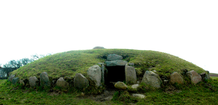
Beautifully cared for, this is an imposing and very complete barrow, which has a huge ‘pre-mound’ – presumably natural. If not, it’s a spectacular feat. Although I can’t read Danish, Oldtidsminder På Langeland seems to say it was restored in 1960-61.
The passage is a bit of a squeeze, but the chamber is pretty impressive once inside.

5 April 2006 Looking roughly north towards junction of small road to Herslev and the 305


5 April 2006 Dolmen on its little island, looking roughly SW from the road to Herslev – 305 in background
Access: In a field a few metres from a small road to Herslev, around 50 metres from junction with 305.
Near Herslev on Langeland. From the 9, at the eastern edge of Rudkøbbing take the 305 south for about 6km. Look out for a small road to the left (east) towards Herslev itself and Illebølle. The dolmen is on your right almost immediately, and we were able to pull in without obstructing the narrow road.
Visited 5 April 2006
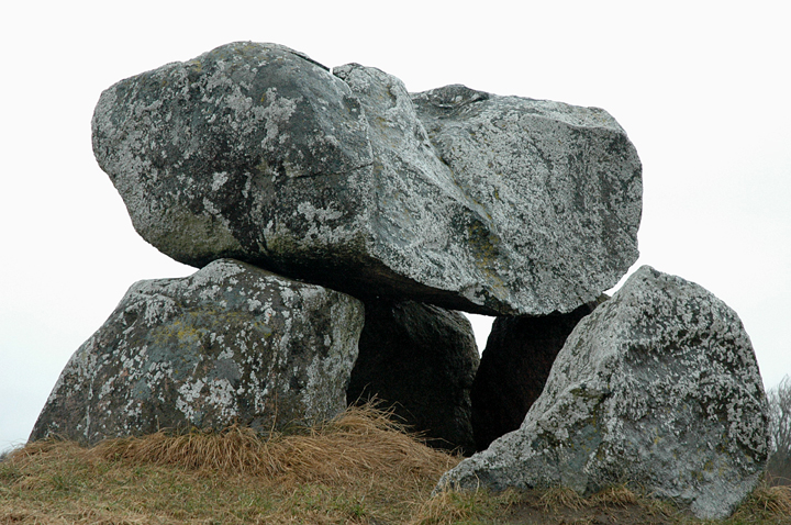
A lovely dolmen more-or-less right next to the 305. And if I remember correctly, there is a factory with big chimneys ‘behind’ it, luckily not close enough to be too distracting. (In fact if I am right, I managed to ‘hide’ it behind the monument in all my photos!)
Featured in The Megalithic European (TME) page 168, but as Jane has explained in her fieldnote, the place poor Julian describes is not Kong Humble’s Grav.
Access: Park at nearest farm which has an honesty box. Walk around 300 metres across field on path that was marked when we were there.
Kong Humble’s Grav is just north of Humble, on Langeland. From the 9, at the eastern edge of Rudkøbbing take the 305 south for about 12km.
Not far after passing through Lindelse, the road distinctly zig-zags through a small village, probably Bogetofte or the outskirts of Kædeby. About 0.75km further south, take a left turn (east) towards Brandsby, by a large white church.
The langdysse is in the field behind the church, but continue past the church maybe 200 metres and turn left up an open drive into a farmyard, where you can park. And – please – donate to the honesty box!
Visited 5 April 2006
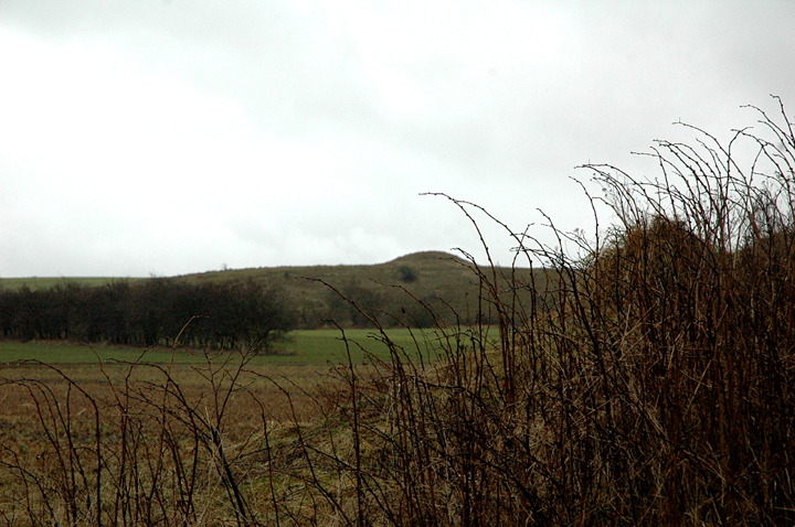
A very cool but largely denuded langdysse, a massive 55 metres long with a fine kerb of 77 large stones. The exposed single chamber is a beauty and all its main stones are pretty hefty!
In contrast to the strange place on the hill opposite the church that Julian describes and photographs in TME, Kong Humble’s Grav lies on open undulating (farm) land, with huge views all round and a very big sky!
Long/lat coordinates are probably right but it was difficult to be 100% sure from aerial photo on the inline map. From the street names and memory, it seems right and I couldn’t see where else it could be!
Access: Right next to residential street, just a few metres into trees. There is a small parking placeSuldrup is around 20km SSW of Aalborg. Travelling north on the E45 I left at junction 33, turning west onto the 535 past Haverslev, heading for Sønderup.
Just under 5km from the motorway, I turned right at a roundabout, still heading for Sønderup. After just over 1km, I took a left into and through Sønderup. Towards the far end of the village, the road bends gently right – keep on this road for just over 5 km and you will be in Suldrup.
Almost as soon as you enter the village, take the 2nd left onto Vikingevej and then first right onto Jættestuevej. When you reach the end, the monument is opposite you, slightly to your left.
Visited 6 April 2006
Right in the centre of the village or small town of Suldrup stands this very nice little passage grave. A little neglected and abused by (I suspect) kids on mountainbikes (a narrow track over the top) its mound is still in place and its chamber quite impressive.
Unfortunately, due to its ‘urban survivor’ position, there is a metal gate which at the time of my visit was locked and I couldn’t find any information on whether it’s at all possible to get access.
This was a shame, as it is one of the Danish passage graves that has an obscure 2nd chamber behind the main one. Frustratingly, I could see its tiny entrance, but couldn’t get to it or get any idea of how big it is etc.
Not one to write home about, but well worth visiting if it’s not too far out of your way!

6 April 2006

6 April Looks more like a fish-pond....

6 April 2006 Overview

6 April 2006 The only part of the site that wasn’t flooded
Access: There is a grassed area between the road and the trees surrounding the site where I parked – it seems to be the intention, but I can’t guarantee it! A path leads north through the trees into a clearing, where you will find the site.
Just outside Frederikshavn on the 585. Turn off the E45 onto the 585 west towards Kilden, Gærum, Øster Vrå and Brønderlev. Just over 1.5km along the 585 there is a right turn north, with traffic islands.
Immediately after the traffic islands, trees appear on both sides of the 585, just at this point on the right (north) there is a small entrance – drive in! I parked on the grassy area to the left.
Visited 6 April 2006
Hmmm. This is a strange site! These are some iron-age ‘cellars’ thought to be the only remains of a settlement and thought to have been used for ‘storage’. As you can probably guess, I had trouble finding any more information! (I came across the place on the Visit Denmark website.)
The fact that on my visit, the strange stone settings were mostly so flooded that they looked like ornamental ponds just added to the oddness.
Access: You can park very close to the west end of the langdysse. A walk of only a few metres across a field, but the langdysse itself stands on a steepish moundlike ridge (presumably at least partly formed by ploughing each side....)
In the north of Jutland, off the west side of the 585 between Frederikshavn and Brønderlev. Just south of Gærum there are a set of 3 højs more-or-less right next to the 585 – one to the west of the road and 2 to the east.
If you stop here and look to the WNW of the western barrow, you will see a ‘suspicious-looking’ ridge with scrubby growth. This is in fact the langdysse.
Visited 6 April 2006
I spotted this langdysse while taking a quick look at some nearby højs on the 585, on my way to Jættestuen Blakshøj. To the WNW I could see a ‘mound-cum-ridge’ which I thought for the sake of 5 minutes needed closer inspection.
My suspicions were confirmed by an information board which gave the name of this langdysse. From my quick look, it doesn’t seem terribly well-preserved and so I decided not to spend any time here, as I had so much to see....

6 April 2006 Inside huge chamber – looking to south end, passage on left

6 April 2006 Looking towards northern end of huge chamber, passage to right


6 April 2006 Approaching from parking place looking roughly east
Access: Walk of a few metres from small layby next to farm buildings.
In the north of Jutland, off the west side of the 585 between Frederikshavn and Brønderlev. Just south of Gærum there are a set of 3 højs more-or-less right next to the 585 – one to the west of the road and 2 to the east, see Stenstuen.
South of here, the next road off to the west goes to a large industrial-looking farm. Take this and drive to the small layby next to the farm buildings.
Visited 6 April 2006
A beauty!!! At 4.5 metres high, apparently one of the largest burial mounds in Denmark. Huge chamber from a short and low passage.
The passage is set in a curious section of the mound which is ‘scooped away’. I would assume that this is from a rather insensitive excavation, not part of the original form of the monument.

6 April 2006 The dolmen on the remanants of its mound, from roughly the SW


6 April 2006 Approaching from the carpark (north)
Access: Walk of around 300 metres across fields from carpark.
Tornby is in the far north of Jutland about 7km south of Hirtshals. The simplest route from the south (not the way I went!) is to take the E39 between Aalborg and Hirtshals, leaving at junction 3 onto the 35 west through Hjørring.
Just outside Hjørring, the 35 meets the 55 at a roundabout. Turn right onto the 55 (north), which will take you to Tornby. Continue through Tornby and a short distance out the other (north) side.
On the right (east), you will soon see some large factories or warehouses. Opposite these there is a line of trees next to the road and behind them is a carpark, partly for a restaurant-type place (I think that’s what it was) and partly for the monument.
Walk to the southern end of the carpark and follow a path SSW. You should almost immediately be able to see the dolmen a few hundred yards in front of you towards the town.
Visited 6 April 2006
A classic late neoloithic dolmen, standing in the almost ploughed out remanants of its mound. Three chamber stones and a chunky littlle capstone.
Another stone stands in front of the ‘open’ end of the dolmen, which I guess could be a moved chamber stone or kerbstone. I suppose it could possibly be a passage stone – if it had a passage – but it seems to be orientated wrongly for that.
Would be a great place to hang out if it wasn’t raining, but on the day I visited it just didn’t stop all day....

6 April 2006 Groundplan of the multiple chambers taken from info board by monument
6 April 2006 Imposing barrow to the south – I’d have loved to have had time to go and investigate this one!


6 April 2006 I couldn’t squeeze into the ‘rearmost’ chamber

6 April 2006 ‘Middle’ chamber looking roughly north, with opening to ‘front’ chamber on right

6 April 2066 Small opening from ‘front’ chamber to ‘middle’ one

6 April 2006 ‘Front’ chamber looking south with entrance on left

6 April 2006 Gate was unlocked, but even the entrance to this one’s a squeeze


