


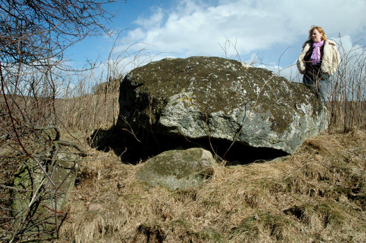
3 April 2006 The chamber looking approximately north


3 April 2006 The info board showing a 4-phase development of the ‘main’ mound & details of the other elements of the site

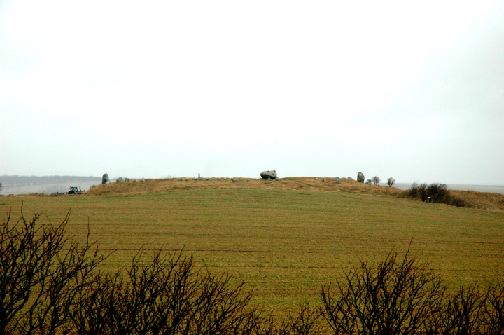
3 April 2006 Looking roughly north over the various remains

3 April 2006 Looking roughly north over a smaller burial mound – note bits of wind turbines in background....

3 April 2006 Curious central setting of main burial – wish I could read the info board!

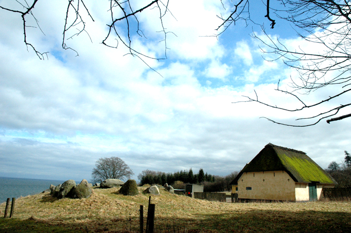
3 April 2006 First view of the site, with industry looming


6 April 2006 Looking roughly SW along the top of the mound


6 April 2006 Slightly ‘shortened’ by being a pano, looking roughly NW – pano made using Autostitch cs.ubc.ca/~mbrown/autostitch/autostitch.html – simple to use, free, non-invasive software


6 April 2006 Troldkirken from top of nearby barrow – taken with a big lens


6 April 2006 A view north approaching along the muddy ‘Troldkirkenvej‘

6 April 2006 The view you get not long after setting off from the layby – notice nearby round barrow on right (Troldkirken on left horizon)
Featured in The Megalithic European (TME) page 159.
Access: Walk of around 500m along clear and reasonably even track, gently climbing. Very muddy in the weather I was there in! The final section is a path across a field, which may be slippery and is a good bit steeper.
Troldkirken is about 9km west of Aalborg. To reach the monument, take the 187 E-W between Aalborg and Sønderholm.
Just to the east of Sønderholm, turn south to Store Restrup (St Restrup). When you reach a crossroads with a more major road, turn right (west) and continue for about 1km – when the road is going uphill you are close.
There is a layby on the north side of the road for parking, and a signpost for Troldkirken – but it’s so huge you’ll be able to see it clearly on its little hill from the road.
Visited 6 April 2006
‘The Troll’s Church’ is a big ‘un!! On the day I saw it, it was a big wet ‘un! (Please excuse the raindrops on the photos!)
The small hill (exaggerated by quarrying in the past) it stands on is visible from miles around. From the south, the langdysse, and particularly the huge chamber are clearly visible.
As a matter of fact, I’d forgotten that there is more here than just the dolmen. Although reduced to the level of the bottom of the chamber, this is still an impressive earthwork, 90m long, with plenty of big kerbstones to impress. (Bit of a shame they’ve been joined by a concrete ‘trig’ point!)
You have plenty of time to get to appreciate its positioning on the walk up Troldkirkenvej, and there is a very nice round barrow ‘høj’ to add some extra interest to the walk. The view of Troldirken itself to the NW from the top of the høj is superb – I recommend it highly.
By the way, if you look at the ‘inline map’ for Troldkirken by clicking the ‘Show map’ link near the top of this page, there are some interesting cropmarks around the site, most noticeably some immediately to the SW of Troldkirken itself.


4 April 2006 Approaching from road – not sure how we spotted it!
Map co-ordinates are probably right, I hope, but it was difficult to spot for sure in aerial photos. Should be easy to find anyway if you know it’s around there, as we just spotted it while passing!
Access: Short walk down fairly rough field-edge ‘verge’.
For directions, see Mols/Porskær Stenhus. Continue east along this road, keeping a watch out to the left (NW) as you go up the hill.
Visited 4 April 2006
Made up name, as I’ve not been able to find out anything at all about this barrow.
Not spectacular by any means, but worth a look for the chunky capstone alone. A nice surprise, especially considering we nearly didn’t go and look!
Details of monuments in Danish – some nice photos & useful maps. The rest of the website is one of the best I’ve found for Danish stuff, though it only covers a (fairly large) area around Århus.
Featured in The Megalithic European (TME) page 161.
Access: Bit of a walk from the carpark – perhaps a few hundred metres along a decent path, down into a reasonably steep little valley, across a wooden bridge and up the other side.
In Djursland, NE of Århus.
We went here from Mols (or Porskær Stenhus, as it’s more often known). It’s a bit of a winding wander through minor roads, but very rewarding, as there are a few other minor (but cool) sites to search out on the way. The first few of these are spottable if you contininue on the road past Porskær Stenhus.
I’ll try to describe this way, as the route directly from the E45 is pretty simple until you join our route anyway! (Junction 42 onto the 16 east, which becomes the 21. Left onto the 547 and then right to Tustrup village before you reach Fjellerup. Then 0.5km before Tustrup village, turn right (west). The carpark is on the left about 1.5km-2km along this road.
So, from Porskær Stenhus we coninued east along the same road towards Agri. Within a couple of km at most, we noticed a wrecked barrow to the left in a scrubby bit of a field boundary – which I’ve called Porskærvej un-named.
We went straight through Agri (pretty place), and after about half a km, the barrows of Stabelhøje are unmissable on the left. At some point around here, we also saw a couple of wrecked barrows I’ve yet to identify, but you won’t miss them as they were right next to the road. We continued on towards Tåstrup (not Tustrup!!!).
From Tåstrup it gets difficult to remember for sure exactly the way we navigated the maze of minor roads, which is a shame because we saw a really nice dolmen (to be identified) on the right of one of the little lanes.
Given that, I’ll just say that we headed for Kolind, Koed, Nimtofte and then Tustrup. Just over 0.5km north of Tustrup, there is a crossroads – turn west here. The carpark for the site is about 1.5km-2km along on the left with a sign.
Visited 4 April 2006
Good map (& probably info boards if we could have read them) in the carpark to whet the megalithic appetite. A short walk crossing a pretty stream and then – a small megalithic showroom!!
We were blessed with the weather again and were able to spend a goodly time wandering here and getting our heads round this place. Another spellbinder.
Visited 4 April 2006
Essentially a dolmen – probably a passage grave – without a capstone. Still very impressive, as the remaining slabs are very substantial chunks of stone!
Visited 4 April 2006
An impressive passage grave with mound pretty much intact, but one of the (I think) 5 capstones is missing from its 10m chamber.
The passage is short, but has no capstones, making it fairly easy to get into, though the chamber itself is fairly low – you have to squat when under the capstones.
Visited 4 April 2006
Hmmm. Thought this one looked interesting in The Megalithic European & it is an odd one – to me at least.
Always assuming the restoration is accurate (& I have no reason to think otherwise) I’ve not really seen anything like the way it is constructed before, with the whole relatively small mound surrounded by such a tall revetment wall.
The construction of the wall itself reminded me of part of Wayland’s Smithy’s frontage. The construction as a whole, though, faintly reminded me of a ‘compressed’ version of The Great Tomb on Porth Hellick Down in the Isles of Scilly (though the construction of the revetment is different there, being ‘straightforward’ drystone wall).
I couldn’t help wondering if the whole thing was originally covered by a larger mound – but then I guess the excavations would have discovered that.
Visited 4 April 2006
Possibly the most unusual part of the complex, and as a result, particularly interesting. Unfortunately, it’s also the one that is least complete – largely because much of it was made of wood that was burnt down. The diagrams on the info board help though!
Apparently, the walls were a metre thick. In the centre was an oval pit with clean sand in it and at each ‘side’ were fairly sizeable collections of middle-neolithic pottery.

5 April 2006 From roughly east, broken possible kerb or passage stone in foreground
Featured in The Megalithic European (TME) page 168.
Access: It is just about possible to park on the farm track that crosses the field past the monument. Then a walk of around 100m across the field which was ploughed when we were there. If the field is in crop, you may not be able to get to the dolmen.
Bjerrebygaard is on Langeland. Cross the bridge to Langeland and travel just over 2.5km along the 9. Take a left turn (north) onto the 305 towards Tullebølle, Tranekær and Lohals.
The dolmen is just over 1.5km along this road on the left (west) clearly visible with 6 large trees on its mound, just before a wood.
Visited 5 April 2006
This was the first place we visited on Langeland, which turned out to be a veritable megalithic wonderland, the highlight of our trip & a wonderful birthday present for me!
It’s a shame Julian wasn’t able to cover the island’s monuments in more detail – there were so many interesting or attractive sites that we came back 2 days later to investigate more!
This is a beautiful chunky ‘double dolmen’, set on a largish mound. It’s a little knocked about and according to James Dyer in Discovering Archaeology in Denmark was originally a long barrow (or langdysse).
There are 2 chambers which are basically in good condition though one of the capstones has slipped down at the end where it meets the other chamber and is now wedged at an angle.
A couple of stones at the SE end suggest a passage and there are several other large stones on the mound (mostly to the west) some of which I’d assume may be (or have been) kerbstones and maybe, passage stones.
Dyer mentions 3 stones of another passage to the NW chamber, but I couldn’t really see what he means – though they may have been moved since his visit, as the book was punished in 1972....

