


2 April 2006 4th chamber (counting from east end)


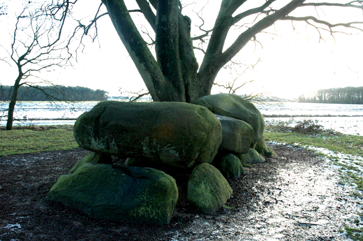
2 April 2006 3rd chamber (counting from east end)


2 April 2006 2nd chamber (counting from east end)


Access: Good. The two main monuments are right next to the road, one each side.
From Frydendal Øst, continue north west along the road (which becomes langedyssevej), passing Frydendal Øst. However, when the road forks, you need the right turn onto Nørreskovej. There is a large white house (called Havrekobbelhus!) at this junction, you need to pass it on your left.
A few hundred metres on, you will see a layby-type space on your right, and the monuments are just around the next bend.
Visited 3 April 2006
Nice! Three langdysser – I’d describe one as ‘beautifully broken’, one as not badly preserved & the other pretty totally trashed & unimpressive.
The one on the south of the road is splendid, featuring the remains of a beautiful kerb and the remains of a couple of chambers. Probably as a result of the remaining kerb, it has retained its classic langdysse shape very well, albeit I would assume, considerably lower than it would originally have been.
The other reasonably well-preserved one (nearest to the road on the north) – let’s call it the ‘middle’one – only has a few kerb-type stones. But it’s noteable for a lovely ruined chamber with a large capstone & the remains of a passage to the east.
The final, most northerly barrow is basically a large low mound ‘behind’ the dysse on the north edge of the road. It has a few large stones on it, but I have to admit I don’t remember the remains of a four sided chamber that James Dyer mentions in Discovering Archaeology in Denmark.
A beautiful & peaceful place for a picnic on a nice day – there’s even a picnic table provided.

3 April 2006 The most northerly & most destroyed langdysse


3 April 2006 Nearby trashed & overgrown langdysse (probably – certainly some kind of barrow)

3 April 2006 View back (roughly) NNW over main site from Runddysse


3 April 2006 The more northerly of the 2 langdysser, looking NNW(ish)
Approximate long/lat coordinates only, but shouldn’t be too hard to find.
Featured in The Megalithic European (TME) page 155.
Access: In woodland, you can get close enough by car to see the monuments through the trees. The ground around the monuments is typical woodland mud, which may be slippery when wet.
Blommeskobbel is on the island of Als, so travel towards Sønderborg on the 8. We went a slightly different way to Julian in TME, but it looked simpler on the map.
Shortly after a roundabout at Bro, we took a right towards Kettingskov. As we reached Kettingskov, at a crossroads with a slightly more major road – Østkystvejen – we turned left and then took the next right, which is unconfusingly called Blommskobbel!
This is where we rejoined Julian’s route. Less than 50m along ‘Blommeskobbel’, fork left towards the woods. The road goes into the woods, and once into the woods, when it forks again you need to take the left fork.
The monuments are visible on your right after you have been in the woods for less than 1km.
Visited 2 April 2006
Another must-see & a cool place (in more ways than one when we went!) We spent quite a while here, despite the rain & cold. Which is saying something considering Jane’s aversion to cold....
Two langdysser, a denuded but recogniseable runddysse & a diddy dolmen (probably also from a runddysse)! And those langdysser are beauties – big & beefy!!! (Not nearly as long as Landeskov langdysse 1, but somehow more impressive to me....)
The ruined runddysse and the other remaining dolmen squeezed against a tree also add hugely to the site and the whole complex merits a good deal of examination.
Interesting to try to photograph because of the trees – at least they weren’t in leaf! The trees also do an amazingly good (or rather, bad) job of hiding the fact that you are so close to the sea – a view of which would add yet another dimension to the site!
I believe the woods contain a good few other monuments, but that these are at least mostly, or possibly completely, trashed.
We did find nearby the wrecked and difficult to find (& access!) overgrown remains of another barrow – probably another langdysse. Hardly worth seeing, and I’m afraid I can’t remember reliably exactly how to find it. I think it was a little way back up the access road (100m maybe, on the ‘field’ side).


3 April 2006 ‘Middle’ langdysse – remains of chamber & passage


3 April 2006 Southern langdysse – ruined southern chamber

3 April 2006 Southern langdysse – ruined northern chamber


Fairly approximate long/lat coordinates only, as I couldn’t spot the monument among the trees on the arial photomap. They shouldn’t be far out though.
Access: A 200m walk through the woods on paths north from Havrekobbel. I just followed what looked like the ‘main’ paths & they took me straight to the monument. You could approach up from the Troldhøj road which is the next turning north, to the west of Havrekobbel, but it’s quite steep and I’m not sure how easy it would be to spot the site on the hillside amongst the trees.
For road directions, see Frydendal Kro and continue north & west past Frydendal Øst to Havrekobbel.
Visited 3 April 2006
A pretty spot overlooking a small valley with a road at the bottom.
Can’t help thinking that without the forestry, the view might well be
beautiful – in retrospect I wonder if the sea might once have visible. I suspect not, as the valley bears to the east.
The ‘Old Troll’s Hill’ is a pretty well-preserved runddysse (round barrow). Excavations found a 17cm flint dagger at the bottom of the mound and a bronze-age urn in the chamber.
It has a relatively undamaged mound which is made more dramatic by being built on a the highest point of a steepish valley. To complete the picture, it has a nice exposed chunky chamber, complete with capstone. A little beauty!

3 April 2006 Looking up the very last bit of the slope that decends to the nearest road – it’d be a hardish climb!


Approximate long/lat coordinates only, but shouldn’t be too hard to find – famous last words!
Access: In woodland, a short walk through the trees on fairly level & fairly even ground. May be boggy and/or slippery in wet weather. Just about visible from road – you can certainly see the road from the monuments, at least when the trees aren’t covered in leaves!
On the island of Als, so travel towards Sønderborg on the 8. Continue on the 8 until you are nearly at Fynshav, looking out for a turning left to Helleved (& probably Elstrup) – the road may be called Katry. Take this and prepare to take the next right, ‘Helved’ (not sure if there is a sign that tells you its name).
The road bears left and enters a forest. At the first crossroads (very approximately 1km along this road) turn right and pretty much immediately, the monuments are in the trees on your right.
Visited 2 April 2006
Here there is a dolmen in the almost flattened remains of its runddysse mound, and a very ‘shallow’ (flattened, I assume) langdysse with an open cist-like chamber.
Pretty underwhelming, but worth a look if you’re travelling to the more impressive sites in the area.
Apparently, on the other side of the road, there are 3 large burial mounds. We didn’t investigate, as the trees on that side seemed much more dense....


3 April 2006 Flattened langdysse looking west(ish) towards nearest road

3 April 2006 Jane inspects runddysse’s chamber – our car in the background showing where the road is

3 April 2006 Runddysse chamber in the shallow remains of its mound
Approximate long/lat coordinates, as I couldn’t see the site among the trees on the aerial photomap. We just happened to spot the site on the right of the road travelling NW from Frydendal Kro, so shouldn’t be too hard to find!
Access: Through reasonably even undulating wood, visible from road, at least when trees are not in leaf!. For directions, see Frydendal Kro.
Visited 3 April 2006
Spotted this one from the road just after leaving Frydendal Kro. Nothing terribly spectacular, but worth keeping an eye-out for – chunky chamber stones & large mound.


