


Friday 2 October 2009 Pano created using Autostitch free beta version autostitch.net


Friday 2 October 2009 Engravings opposite entrance (the ‘breasts & necklace’ look more like a smiley face in my pic – sorry!)

Friday 2 October 2009 The accessible part of the allee


Friday 2 October 2009 Even the ‘diddy one’ is taller than most people (see Jane next to it in the shadows)


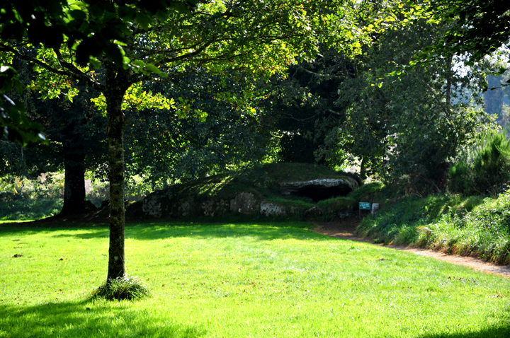
Wednesday 30 September 2009 View of monument looking east from road

Access: Samuel Lewis in ‘Guide to the Menhirs and other Megaliths of Central Brittany’ says this is on the right (west) of the dead-end road to Kerangle farm. It’s not, it’s on the left (east). He’s placed it correctly on the map, but unfortunately in this case the map is on a different page. Sod’s law meant that we followed his instructions instead of his map!
So, as you clear a line of trees to the east of the road approaching the farm at the end of the road, keep your eyes peeled to the left (east). At the far side of a large field with woods beyond, you should be able to spot the monument if it’s not in crop (though it was quite overgrown when we first saw it).
It was a bit of a slog around the edge of the ploughed field, but if it had been in crop, we would never have spotted it!
Visited Wednesday 30 September 2009
Thought we’d missed this one as the field on the right (west) was in crop & we thought that’s where it was (see above). Tried to ask at the farm. but there was no answer
Luckily, as we gave up & drove back down the road, Jane spotted something on the far side of a field to the east.
It was a fair way off & we couldn’t be sure, but especially as this was our last site of the day & we wouldn’t be back, I decided to trog around the field edge.
For much of the walk, my view was blocked by trees, but as I cleared them it looked like this was probably it, but it looked overgrown & trashed.
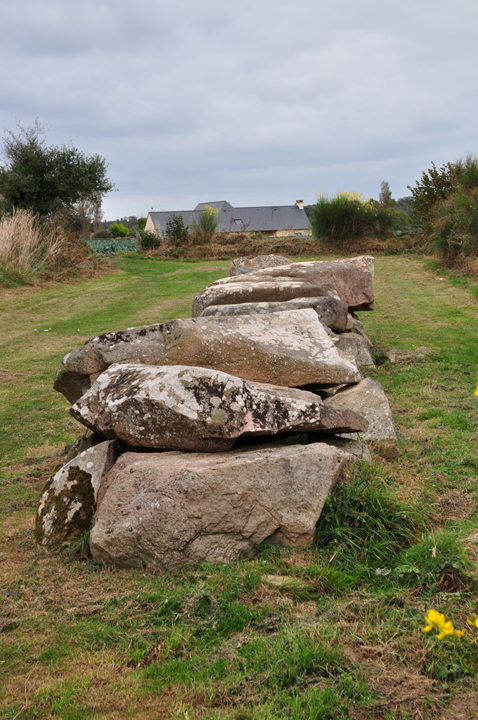
How wrong I was! Once I’d tramped down a lot of fern, bracken & bramble (less hard work than I expected) I could see quite a cool little allee couverte. (All my photos are post-’gardening’!)
It’s not in great condition, but I still found it very pleasing. Lewis speculates that it may have been built with one of the capstones only supported on one side, but I thought this unlikely. I may be wrong of course!
Access: When we were there it was in deep crop (see photo under ‘maps etc’) & we drove straight past. As you reach the area of the dolmen, at a t-junction at the top of a hill look out for this ‘telegraph pole’ with signs on.
The dolmen is along a path starting a few yards to the left of the (French-style) telegraph pole. You can just make it out in the photo – near the back of the car. (We interpreted the signs as meaning drive along the road to the left & spent ages looking for the dolmen in the wrong place!)
The path was narrow & a little rough with the maize encroaching, but would otherwise probably be pretty easy.
Wednesday 30 September 2009
A nice simple but quite large dolmen. A bit underwhelming when we were there as it was claustrophobically enclosed in high maize crop, and the weather was unpleasant.
Without the crop and with some kind of setting visible, I suspect it would be far more impressive.
There is also a stele somewhere nearby. I think it’s in the same field but the photo I’ve seen makes it look pretty unimpressive & the chances of finding it in the maize seemed slim!


Wednesday 30 September 2009 (Sorry about the car!) As you reach the area of the dolmen, at a t-junction at the top of a hill look out for this ‘telegraph pole’ with signs on. The dolmen is along the path you can just make out at the back of the car. (We interpreted the signs as meaning drive along the road to the left & spent ages looking for the dolmen in the wrong place!)


Access: Easy. Drive to the church & get out of the car!
Visited Wednesday 30 September 2009
Not much to add to what Jane said, except that although we read that these are the remains of a cromlech, in ‘Megalithic Brittany’ Burl says it they are the remnants of an allee couverte.
Giot in ‘La Bretagne des Megalithes’ reckons it’s the base of a neolithic tumulus.
This seems strange to us, though I guess it’s possible if these are strangely varied & spectacular kerbstones.


Wednesday 30 September 2009 Note alleged triangular entrance, possibly the least convincing of the three


Wednesday 30 September 2009 See alleged triangular entrance in transverse stone

Wednesday 30 September 2009 Pano created using Autostitch free beta version autostitch.net


Wednesday 30 September 2009 Alleged ‘entrance’ stone in foreground
There seems to be much confusion over which of the three Liscuis Allee Couvertes is which. Different sources call different monuments I, II & III. We have followed what seems to be the standard French numbering.
Pierre-Roland Giot, for example, calls this Liscuis II in ‘La Bretagne des Megalithes’, whereas Aubrey Burl seems to refer to it as Liscuis III.
Access: The nearest place to park is on a minor road to the north of the monuments just south of the N164. Once on this road, look out for a parking place by small christian monument on the north of the lane through trees. There is a track opposite, heading south – uphill. (There is also a map of the area here, though it doesn’t show the allee couvertes as far as we could tell.)
The track is reasonably steep for some distance but levels out and the path around the three monuments is pretty easy. I’d guess the whole round trip including all three monuments is around 2km, tops.
I’d advise continuing on the path until around the top of the hill where there is a track to the right with an infoboard.
Then follow this path past all three monuments (keeping right to follow a clockwise circuit). From Googlemaps it looks like you could do the circuit the other way round, but I think the turning would be harder to spot that way.
Visited Wednesday 30 September 2009
The last of the Liscuis trio we saw is slightly overgrown and more ‘knocked-about’ than the other two. It retains only one capstone and is again constructed of the local schist (according to Burl).
Like the other Liscuis monuments it has an small triangular original entrance to its passage formed by a transverse stone with a lower corner missing.
As with Liscuis III this ‘entrance’ isn’t entirely convincing to me on its own, as the passage stone that forms the triangle with the transverse stone leans quite dramatically (surely more than it could have when it supported a capstone). But I guess the fact that all three neighbouring tombs have this feature in some form makes it pretty likely to be genuine!
There seems to be much confusion over which of the three Liscuis Allee Couvertes is which. Different sources call different monuments I, II & III. We have followed what seems to be the standard French numbering.
Pierre-Roland Giot, for example, calls this Liscuis III in ‘La Bretagne des Megalithes’, whereas Aubrey Burl seems to refer to it as Liscuis I.
Access: The nearest place to park is on a minor road to the north of the monuments just south of the N164. Once on this road, look out for a parking place by small christian monument on the north of the lane through trees. There is a track opposite, heading south – uphill. (There is also a map of the area here, though it doesn’t show the allee couvertes as far as we could tell.)
The track is reasonably steep for some distance but levels out and the path around the three monuments is pretty easy. I’d guess the whole round trip including all three monuments is around 2km, tops.
I’d advise continuing on the path until around the top of the hill where there is a track to the right with an infoboard.
Then follow this path past all three monuments (keeping right to follow a clockwise circuit). From Googlemaps it looks like you could do the circuit the other way round, but I think the turning would be harder to spot that way.
Visited Wednesday 30 September 2009
The middle of the Liscuis trio we saw is less overgrown than the other two, though more so than in some photos I’ve seen.
It is the most complete and impressive of the three and occupies a dominant position on a ridge at the crest of the hill.
Very nice monument, again constructed of the local schist (according to Burl). Like the other Liscuis monuments it has an small triangular original entrance to its passage. To me it is less convincingly an entrance than at Liscuis I as the stone that forms it is less a complete transverse & more of ‘a stone at an angle’!
There seems to be much confusion over which of the three Liscuis Allee Couvertes is which. Different sources call different monuments I, II & III. We have followed what seems to be the standard French numbering.
Pierre-Roland Giot, for example, calls this Liscuis I in ‘La Bretagne des Megalithes’, whereas Aubrey Burl seems to refer to it as Liscuis II.
Access: The nearest place to park is on a minor road to the north of the monuments just south of the N164. Once on this road, look out for a parking place by small christian monument on the north of the lane through trees. There is a track opposite, heading south – uphill. (There is also a map of the area here, though it doesn’t show the allee couvertes as far as we could tell.)
The track is reasonably steep for some distance but levels out and the path around the three monuments is pretty easy. I’d guess the whole round trip including all three monuments is around 2km, tops.
I’d advise continuing on the path until around the top of the hill where there is a track to the right with an infoboard.
Then follow this path past all three monuments (keeping right to follow a clockwise circuit). From Googlemaps it looks like you could do the circuit the other way round, but I think the turning would be harder to spot that way.
Visited Wednesday 30 September 2009
The first of the Liscuis trio we saw is still semi-subterranean & was rather overgrown. It was also in slightly less good condition than I expected though it retains three capstones.
Still a nice monument made of local almost slate-like stone (schist, according to Burl). Interestingly it has a transverse stone with one lower corner chipped away which (again according to Burl) was the original entrance.
Access: A few hundred yards into a wood on a pretty good path. A bit further into the wood, I believe there is a fairly impressive menhir ‘Mein al Has’ but this was already a detour & we didn’t have time for menhirs today! (Roc’h ar Lein menhir is also nearby, further up the road.)
Visited Wednesday 30 September 2009
This wasn’t in the plan, but we saw signs to it & just went. Actually, if we’d realised the sign was ‘just’ for this fairly unimpressive capless allee couverte & the menhirs mentioned above, we may not have detoured!


Visited Wednesday 30 September 2009
No proper access notes, as I can’t remember how easy it was to get into the field.
Living proof that you can’t go far in Brittany without seeing something megalithic – we just happened to notice it as we were driving past....
Nice menhir.


Wednesday 30 September 2009

Wednesday 30 September 2009