
Cup-marks on Burroo Ned. The Calf of Man is in the background.
Image credit: David J Radcliffe
Cup-marks on Burroo Ned. The Calf of Man is in the background.

A photograph of a cast taken. Scanned from page 7 of the 11th Annual Report of the Manx Museum and Ancient Monument Trustees, year ending 31st March 1916.
I visited again on 8th June 2004 and got some half-decent photos. I think an overcast day is best! The spirals do not seem to be as clear as they were several years ago, when I took my previous photos.
Please note this site is by the edge of the road, and not one and a half fields up the hill as the latest digitised footpath map shows!

The spirals are there folks! Here’s a recent photo...
The OS map shows both the sites described by Kammer, there is possibly a third mound just 2 metres to the west of the heather covered mound. The SMR describes them all as Dalby Mountain Burial Mound, and then gives them A, B & C suffixes. I prefer to call them Dalby Mountain South West Mounds A & B. The land is owned by the Manx Wildlife Trust and is publically accessible.
On the other photograph, the brown cow does indeed stand in front of the mound, which I call Dalby Mountain (west of road). This is on private land, and was excavated in the past and cremation urns recovered.

A pre-historic hut circle?

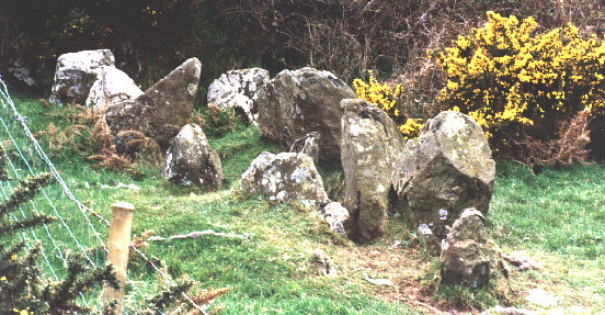
The re-erected stones of Ballaharra, now at St. John’s. They could not be re-erected into their correct positions because the local Women’s Institute wouldn’t allow their rose-bed to be moved! The stones were exposed by sand quarrying about a mile down the road towards Peel.

From the air you can see a circular sort of structure within which the church sits...

I’m not convinced this site should be included, as it is sometimes considered to be from the Norse period i.e. 10th/11th centuries, however it is possible that the hill is natural and could therefore have been used in earlier times...
This site, also known as the Giant’s Grave, is in the corner of a field which currently has some horses in it. The nearest stone has recently been damaged (a chunk knocked off it), and the earth between the stones eroded down a couple of inches – presumably by the horses wandering through. The hedge on the left has also been trimmed severely recently, and this I am told has revealed another couple of large stones.
The last time I visited The Spiral Stone (October 2003) I couldn’t see anything carved on it either, but I knew I had photographed it a few years previously, and now realise that the spiral carving is very low down on the stone. I think you also need the right sort of light. I have posted my photo of the spiral carving from several years ago so that you will know why the stone is so called!

There is a spiral design on The Spiral Stone but it is right at the base and often covered by grass! It isn’t particularly easy to make out even then...