
S side of the Point itself
Image credit: wideford
S side of the Point itself

Marwick’s structure I presume
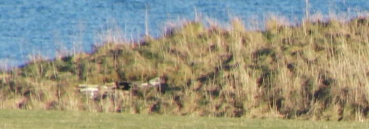
In the 1930’s Marwick spotted settlement remains at the Point of Quoyelsh. During visits in 1989-1990 D.Lynn and B.Bell found pottery and stone finds there, with a body sherd giving the site a date likely to be no later than the Iron Age, and found the surviving corner of a (?domestic) structure (RCAHMS NMRS record no.HY20NE 73 ). Dave describes the site as about two-thirds of the way up a cliff section below a slight surface rise, adding that there is also grassed mound set back from the cliff edge nearby. From my photos he believes that the deeper masonry [closeup 1] is ‘newly’ exposed and suggestive of better survival than originally thought. Along the southern side of the Point itself there may be other archaeological traces as by the base there is a long white something I only spotted on a photo that looks good for Marwick’s find – could be mediaeval like Head of Houton carved stone or there is a slim possibilty that it came from White House around the corner as I have known whole sections of brick wall to be washed up on the shore in Orkney. A little further north along this half of the Bay of Navershaw another settlement is partly exposed cliffside (HY20NE 24 at HY268092 probably Neolithic) but I did not know this at the time
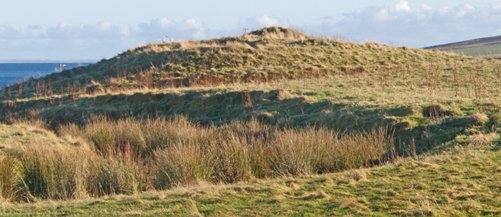
Armed with the new information I walked the Grimeston road, which is basically a broad U-shape. Coming up the northern leg you come to a T-junction. Here a short stretch of road goes north to the Stoneyhill Road. At the end of it is the field of the ‘Feolquoy’ mounds with another such to its north and that containing the Staney Hill long cairn to thats north. The field above this short piece [i.e to its east] has the Staney Hill standing stone itself. At this junction the main portion of Henge is in the field on the right, though of course this would have been one with the standing stone field before the’modern’ road. In the near (SW) corner I could see a very well defined feature, a circular bank not many yards across around a flat depression full up with flat stones or slabs. When you are almost at the highest point of Staney Hill there is a very large curving ridge running across, with the supposed entrance a few yards wide clear to see. It is most definitely the line of an old track. Which isn’t to say that this could not have been placed along a causeway which its construction destroyed. Turn your eyes to the other side of the road and at the highest point there is a distinct low mound that Dave said would originally have been the place to which all eyes were drawn, rather than the common idea that such heights are for looking down on folk and other sites. Looking downhill/W I could now make out another ridge. This is lower to the ground. Which is another reason to suspect we are dealing with natural features, for one would expect this to be the henge’s higher standing section of bank (as with, say, the Hillhead enclosure). The whole of the Staney Hill and Grimeston area is covered with the likes of surviving and dead burns, rocky outcrops, marshy bits. Which would explain why the tracks shown in 1882 are very far from straight. Unfortunately there were several pockets of sheep preventing my closer viewing of the uphill part. Also if there is archaeology here it would probably need pointing out by those with the knowledge. At least I now know why there were so few photos – even my sites have to have something to them ! I did, however, investigate the [as it were] ‘ringwork’. Definitely in need of a tidy up. As well as the slabs a lot of the central depression is taken up by a part-buried piece of modern machinery. There are a few visible voids, including one I could see inside. Kneeling down for a closer look in this latter there is about a foot of space into which a short piece of the machinery’s cable projects. There was a possible large stone forming the bottom. Sticking my hand inside I unprofessionally tried to lift this. It broke in two and seems to be simply a clump of earth.
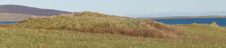
On another visit looking from a point S of Henge across from the south bit of road I could see the land distinctly drop off, and this edge is a very smooth curve visible on the 1:25,000 as a contour line. Roughly West of of Henge is the Staney Hill standing stone. Then there is that ‘viewpoint’ mound, maybe a couple of feet high. Come clockwise and further down is where Andrew extracted a piece of portable art from ploughsoil by the layby, the Grimeston Girlie themodernantiquarian.com/img_fullsize/90302.jpg having similarities to the Westray Wifie found this year. Unless O.A.S. publishes the chap’s doctoral thesis we shall probably hear no more of Henge’s real archaeology as an SMR seems unlikely.
Andrew Appleby (once an excavator of cists) found a possible circle of stones between the Grimeston and Stoneyhill roads.This sparked my interest in the ‘Vola’ mound, but this year I attended an Orkney Archaeological Society talk by an Orkney College student [name escapes me] on a site called Henge, 80m diameter and cut across one end by the road. Described as little known it rings no bells. Unfortunately I could not identify the place from either image shown as this site does not show up well even in person or photograph other than badly. One of these was of a putative entrance, though without scale the devil’s advocate saw a passage into a field across a ditch. If I remember correctly geophysics had located several other interesting features round about. Dave Lynn [ex-Director of the CSA] came to see me and had visited the site, which is where the legend Staney Hill is shown on the 1:25,000 – he said it is by Henge Cottage. When he went water inside clearly defined the ditch, but as to the possible entrance he was of the opinion that this is due to one of the two tracks shown here on the first O.S. [when the present road did not exist].
The Tingwall mound is in the form of a figure-of-eight or else two mounds of disparate sizes have been joined together, the larger and more mutilated at the west end and the smaller at the east by the farm. Using the 1st O.S. to look at the brochs from Dishero to Burgar you find the broch depicted as not quite circular except for the east end of this mound where its circle is a geometric circle. Which seemed strange. Then I had reason to ponder whether the sluice behind had been made using stones from the broch and the light went on – the sluice makes the burn behind a millstream and so this is a strong candidate for being a mill mound. Which isn’t to say that it had no prior use [unless the mound had been constructed specifically for the mill]. The early map isn’t as detailed as that for Dishero, showing a bank occupying the inside of the west circle’s western half and orthostats on the south periphery (seven shown).
On a modern-day aerial view [192.com IIRC] this is generally confirmed, with little appearing at the east quadrant and the stones part of the plant-covered ditch obscuring it from a roadside view. The view from above shows the large irregular pit seen roadside as coming from the south edge of the circle, a little right of centre, up to the broch tower marks with a small circle where it contacts. There are several pits inside the broch tower area. These are probably from antiquarian investigations. To my mind these would post-date the 1880 survey or more detail would be shown on the 1st O.S. (like Dishero). The photo shows a circular ditch on the west side and inside this the broch tower wall in the W-N quadrant with what appears to be an out-turning at the north end, perhaps a gateway or the east side of an external cell. I imagine the ditch to be is connected to the substantial rampart fragment referred to in the NMRS. Virtually nothing can be seen at the east side of the broch circle over or from there to the mill-mound.
All of the foregoing I learned after this particular visit. Coming from the harbour I first came to the eastern end. Looked across this end from the east it is the south side that has been touched by man, at the base on the left what appears to be a low bank across this end, then an apparently manufactured curve to the top and an equally low rise or foundation from whose north side the mound slopes gradually down seemingly naturally. To the right of the ‘foundation’ you can see the top of the broch in the distance. Along the side facing the road a few stones of different sizes are exposed, though truth to tell if they have a pattern it is a line rather than a curve. Even in winter the gouge of a ditch cutting in front of the west end and up into this end of the mound like a stairway to heaven is heavily fringed with dock. Exposed in the cut above are a mix of small thin slabs and blocks. All are still where placed by man, but only in one spot are you priveleged to see a tiny section of plain to see walling. This horizontal block with a slab coming onto it I had previously believed to be part of a small passage entrance but later close inspection reveals a vertical surface behind and below the slab, probably one block and part of another – it feels different from the rest and I would like to think this is the outer face of the broch tower wall.
Up at the crossroads the west end presents the multiple levels now familiar from Dishero. After entering the field I am about halfway to the mound when to my surprise I see a deep ditch cut into the ground by this end just beyond a sharp bend in the burn, and the broch sits on the other side. Up on the mound the bank/s on this end are easier to see. From the top it is more obvious how regular the east end is and there may be another bank between. Spot another interesting thing to my left as I look past a pit to the mound (or top of the mound)’s edge, a broad but very shallow concave curve and what might be slight bumps at either end. Could this be an entranceway ? And if so to the broch or something else ?? I was also surprised by how far back the big ‘hole’ at the south side was from the central broch tump. Beneath the plants at the bottom are some larger stones/slabs. Not sure if these are in situ or whether part of flooring if so. On the west side are fewer stones but there is that ‘wall’. On the east side there is more of a continuity though after several metres it does broaden out suddenly, might be another chamber or whatever. Further down near the lip of the ‘hole’ on this side is something definitely different, a saw-edged orthostat (just visible from the road with magnification) with its face towards me. More like a tomb than broch – though it is considered that this is not a ‘greenfield site’, however the arrow is considered to run forward to Viking times rather from the IA back. Lastly I walked over the the other end down a shallow slope, still above ground level, then up more steeply. Nothing to add to my first observation about the seaward end.
Recovered during this exploration were the remains of at least eight folk, and it is hoped to carry out a fuller excavation this summer [funds possibly an issue].
This site was discovered in September 2010 by Hamish Mowatt of the Skeriies Bistro (hence early confusion over its whereabouts in South Ronaldsay) during work on his holiday homes at Banks. He found that one large flagstone to which no attention had been paid before covered a space in which a skull could be seen. It was soon realised that this was part of a chambered tomb that had suffered water ingress. Later reports added that this lay under a slight mound or ridge, partly removed by a JCB, that though much lower than that of the nearby Tomb of The Eagles would probably also have been seen from the sea. Not only had the tomb been built into the natural but it also started out as a rock-cut. Because this site is one of few found undisturbed in recent decades and it was feared material remains would deteriorate further under the standing water an emergency excavation was decided upon. This took place over two weeks October into November, though time was been lost to bad weather and nothing is yet known of the last few days [?abandoned as weather had worsened still further]. As a tomb entry lay through the short N/S leg of an L-shaped passage (a tee if you add the east chamber). There were five chambers altogether; one small cell off the north side, two small cells off the south side and two larger ones at either end of the long E/W section of the passage. The chambers used corbelled vaulting above courses of single stones. Many skeletal remains were found, chiefly skulls and fragments, but these as far as is known are all part of a final sealing of the tomb. This de-commissioning took place staccato over an extended period of time – basically slabs were placed over the cells, the human remains over these, and then further silty gray material completed the process.
most up-to-date info on 2 week emergency dig (nothing on last days but more than video diary)
Video diary of excavation now includes season 2


broch levels from the north, ditch hidden across centre of image


outer broch northern profile between broch tower wall and ditch
At the south end of the Gorseness road is the sign for the Rendall Doocot. Follow the signs to this and the Knowe of Dishero ‘mound enclosure’ can be seen on the coast from the track that runs from the Hall of Rendall to the South Ettit graveyard [the slabs by a water trough are froman empty cist excavated in 1969]. The site has a new fence around it and no easy access evident – if there had been more time I would have snuck under as there looks to be no ground-level wire. Coming from the end facing the 1738 kiryard I can make out one big broad stone about halfway up that looks to be in a depression I think lies just outside the broch tower. On the side facing the old manse is a broad ditch that seems quite deep and heads for the cliff-edge. It is from this direction that you can make out the various levels i.e. the ditch, the outer broch, and the broch tower [possibly a fourth can be made out]. From here through the clifftop undergrowth you can see what looks to be a mix betwen a sea-wall and a structure back against the cliff, age unknown.
On the 1st 25” O.S. several slopes are shown. On it the site aligns NE/SW, with at the eastern side a rectilinear half (having a sub-rectangular pit [or perhaps stone] at right angles to the longer side half-way along), at the western side an arc of the same length, and at the northern side two arcs of almost similar sizes (the west one less curved) with a gap between them due north. The RCAHMS NMRS record no. HY41NW 6 describes a broch tower of internal diameter nearly 30’ having a 19’6” long section of inner wall-face visible on the west side to a height of some 4’6” with an opening of over 2’6” blocked up in modern times. Inside the east ditch it mentions faint traces of the outer broch wall. The rectilnear half makes me wonder if it hasn’t been re-used by the Vikings, like Castle Howe in Holm.
With there being a possible boundary ditch south of the Tomb of the Eagles it is worth noting that an orthostatic slab south of the Banks Tomb is probably a boundary marker (RCAHMS NMRS record no. ND48SE 8 at ND459833, down as post-mediaeval though how they can be certain of one and not the other...). Also in the area Ronald Simison explored two out of six mounds at ND46128326 (ND48SE 4) both with kerbs and one apparently connected by a causeway to one of the others. He also found a kerb cairn at ND46338323 (ND48SE 3).

Knowe of Midgarth & mound seen from near Midland

Knowe of Midgarth from A966 above with mound behind RH side

cairn looking north-east

N end walling of knowe
N end walling with entrance into knowe visible

Midland tumulus looking north-east

Midland tumulus from shore to the west


