
Pretty impregnable looking, the stone wall is visible. This shot was taken from Hownam rings, a smaller hillfort to the south.
Image credit: IH

Pretty impregnable looking, the stone wall is visible. This shot was taken from Hownam rings, a smaller hillfort to the south.

Cultivation terraces at the foot of Hownsm Law, NT783212. The cows give an idea of scale, but notice the erosion.
I’m not posting this as fieldnotes as I didn’t actually get to the top. However, the Hownam Law merits a mention, not as much because of the IA fort, as because of the striking nature of the hill upon which the fort sits.
When approached from the north, it looks quite unremarkable, yet when approached from the south, it looks totally forbidding and conspicuous. The aspect it presents from The Shearers stone row suggests it may have been significant in the decision to place The Shearers where they are.
From a distance, no earthworks can be seen, but a stone wall is clearly visible, running the entir breadth of the southern side. If there are earthworks surrounding the plateau on the summit, they must be some of the most extensive in the borders. But it would make a darn good fort, even without earthworks, the scarps around the summit would have made it an easily defensible place.
The Kale valley has some very clear cultivation terraces, and those at the foot of Hownam Law are the clearest, and most extensive. Some of which look like they are starting to erode.


Looking NW, from the eastern part of the row, with the earthworks of Hownam rings visible to the right of the picture
Easy to find when approached from Hownam. The path is decent, but rough in places. It’s sheep farming country, so the stones aren’t overgrown.
I Counted 23, (5 hidden?) spread over a slight rise, half and half. There aren’t any other field boundaries in the vicinity that have left such stones as their evidence. Nor could I see any trace of an embankment having ever been over them, though the undulating terrain may hide this. It would make sense to put a boundary between the hillfort at Hownam rings, and The Street. But there are a couple of far more suitable rises running parallel with the Street that would seem to have made more sense as places to put a boundary structure.
They’re not in as straight line as the Merrivale rows,which are all I have to compare them with. So I wouldn’t offer opinion on any deliberate alignment (e.g.Astral bodies, parts of surrounding landscape etc). You can over to the other side of kalewater, where the Five Stanes circle is, but the circle is obscured by a slight rise.
Hownam Rings is clearly visible as hut circles and earthworks. And the outer ring of earthworks has a few stones around it. Almost as if there was something surrounding the Rings that wasn’t earthwork. Just to highlight the complex history of the area, one small (1m)leaning orthostat to the south of the rings has a cup-mark on the outer face. This could be somewhere that has been reused a few times for different purposes. The one thing that cannot be overlooked is the south side of Hownam Law. Before the hillfort was made, Hownam Law would have been very conspicuous from the Rings. Add to this the mound and standing stone at Horseshoe wood, and it’s clearly a complex pattern of sites, possibly covering thousands of years.

Cup-marked stone near the path.
Rock art doesn’t come much simpler than this.
The stone rests on top of a 30m(ish) long, 15m (ish) wide rounded mound that looks suspiciously artificial. Closer inspection shows it has been excavated in a brutal manner a good few years ago, the southern side has a great scoop out of it. There are stones embedded in the surface, under the turf, but none in the excavated section so it possibly is artficial. On the south side, there is a, small, natural looking hole, which maybe part of the reason this particular stone was chosen.
A chat with a Local farmer revealed that the stone fell over a couple of years ago, but was placed back upright in 2003. The entry at the border-stones website relates that before it fell it was leaning at a 55deg angle.
There’s a cup marked earthfast boulder with a single cup mark to the right of the path just before you get to the stone.
As you start up The Street from Hownam, there’s another possible standing stone in the field to the right of the path, just over the stream. It’s about 1.3m high, wider than it is tall. You can’t miss it. It’s got a vaguely circular mark, and has a chunk missing at the bottom.
According to local Tales, the Shearers are associated with a tale of Roman military misfortune.
A general recorded in his journals that he was having not recurrent problems with deserters. Many of the Levied troops from far flung roman provinces would regularly go AWOL. These troops were usually rounded up and punished. However, one group is recorded as having never been found, bar one individual. The chap was incapable of relating the whereabouts of his comrades however, as he had apparently lost his sanity at some point during his unsanctioned holiday. It was “As though he had gazed into the face of Orcus(the Roman god of death and the underworld, similar to Hades in Greek mythology), and his mind struck asunder by the horrors that he saw.”
This is more juicy than the other account for the name, which is that the stones are crop shearers who were petrified for working on the Sabbath. At least they weren’t dancing.
Local information courtesy of Kelspook. (Thanks dude!)

Looking south, the cultivation terraces on Headshaw Law are discernible in the background.

Looking to the east, there’s a Cairn and a settlement on the hill in the back ground.

Looking to the NW, the ‘nipple’ of Hownam Steeple to the left. The hole in the stone is just visible.

From the north, showing the Mound on which the stone stands.
On the far horizon, just to the left of the mound, is Long Knowe, a small hill behind which lies the Five Stanes circle.
With images of the stone before it fell over.

Tallest stones of the southern circle. Other shots mysteriously vanished from memory card.

Tallest stone of the North circle, inexplicably cropped on the memory card.
There are actually two ruined circles. They’re on a flat gravel plain, in a sheltered valley, next to a river. The access is good, as there is a car park at the edge of the field. There’s even an information board, which curiously makes no mention of the circles.
The northern circle is almost totally wrecked, with only a couple of boulders standing to over 1m. The circles are the largest I’ve found in Northumberland, and quite unlike those to the south on the Whin Sill, and very different from that at Duddo. They don’t even bear a passing resemblance to the nearest circle across the hills at Five Stanes.
The southern circle is slightly better preserved, but still has only 9 stones easily found. And 7 are now recumbent, though the packing stones around them indicate this was not always so. There are other stones buried beneath both circles. It’s difficult to say if these were always such open circles, as there were a lot of stones removed in medieval times. Smaller ones would leave no trace. There is a artificial bank leading down to the river, and building on the other side, so this might be a place to look for any of the missing stones.
The EH RSM report states that the stones are still in their original positions, based on the presence of the packing stones at their bases. The damage to the circle took place in the medieval period when the field was farmed. Presumably this didn’t last long, as the start of the border reiver period would have made this prime raiding territory, and arable farming would not have been easy when your neighbours keep stealing all your crops.
The EH report also says that the south circle has a diameter of 61m by 42.7 m, with an average interval of 16-20m between the stones, if those detected by sub-surface probes are included, though it doesn’t actually say how many are underground in the south circle. It goes on to say that the north circle is 60m by 45m, and 6 buried stones have been detected.

Family friendly archaeological visitor centre.
25 Miles from Aberdeen. Indoor and outdoor activities.
Covers neolithic – iron age periods, with a reconstruction of roundhouse etc. I liked it, so did the missus and the bairn.
28 stones, in an east-west alignment.
Known locally as the eleven shearers, possibly because not all of the stones are high enough to be visible.
RACHMS alleges it may be simply the remains of a field boundary.

Searchable lists of prehistoric sites for both Durham and Northumberland. Not a lot of info, but good maps available, and ref numbers for each site, to let people send them requests for more detailed info. Includes a few potential sites that aren’t on the SMR or the RSM. Nb: Durham and Northumberland only.

Based on the sketch in Beckensall’s “Prehistoric Rockart in Northumberland”.
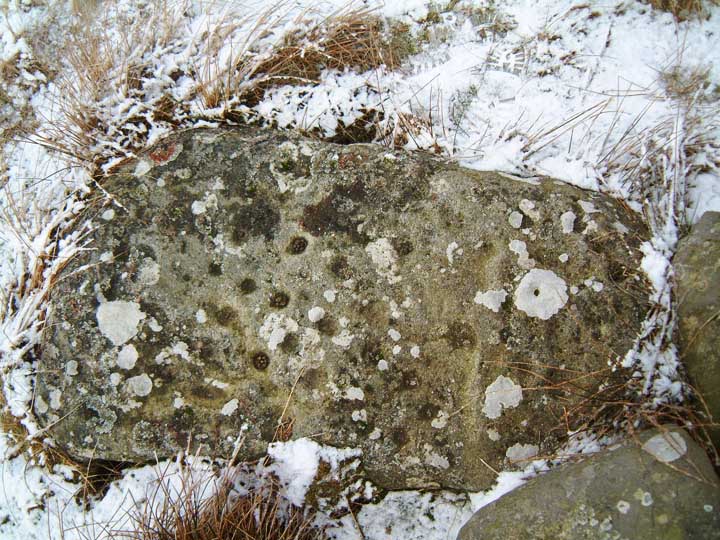
The lichen obscures all but the deepest cups (and those visited by rabbits)

Ridley Common stone circle remains, doing it’s best to hide.

View to the east, showing line of sight to Sewingshield Crags.


An unprepossessing circle, tucked away in a fold of an excellent landscape.
The English Heritage description describes this as the remains of a stone circle, 16m in diameter. It gives the details quoted above by BG, and goes on to say “Within the SW part of the circle there is a small circular mound of stones and earth standing to a height of 0.1m.”
This is pretty accurate, but stretching the meaning of “standing”. Leaning at 45 degrees more like. It’s rather overgrown, and the smaller stones are almost invisible under the marram grass. The circular mound was only discernible as rougher going underfoot
The placement of the circle within the surrounding landscape is worthy of note. It is tucked away in a fold in Ridley Common. Cuddy’s crags to the south, and Greenlee Lough to the north are imposing features, but neither is visible from the circle. A gap in the horizon draws attention to the snazzy natural feature at Queen’s Crags. Investigation of alignments between the circle and this feature may prove interesting. There are a few subliminal recumbent figures in the horizon for those who care to look. The overall effect of it’s placement in the landscape is to make the circle appear to be hiding from any possible viewers.
The circle is close to the Pennine way, but is reached via a private track. It’s also not accessible to anyone who might have trouble getting over a stile. Also note that the private track is marked as unfenced on the OS map. It’s not, so trying a shortcut will probably mean getting entangled in barbed wire.
It’s about 45-60mins from the B6318, which has small lay-bys available for those with cars to park. The spot on the map with the blue phone symbol is probably best for this, but in the real world, there’s not actually a phone to mark the spot, so blink and you miss it.
The New England Antiquities Research Association
“is a non-profit organization dedicated to a better understanding of our historic and prehistoric past through the study and preservation of New England’s stone sites in their cultural context.”
Interesting articles and pics of Sites in New England.


Panel of approximately 40 or so cup marks. The panel is on the most prominent spur of a low ridge of bedrock. Most of the cups are about 5cm diameter and are very worn with a thick covering of lichen. Hence the approximation of the number, some of them may be bumps on the natural surface of the rock.
The panel is easier to find if approached from the south. The ditches and banks of the nearby settlement and the disused quarry make the ridge easy to find. The panel appears to mark the northern edge of the cairnfield. Most of the cairns are quite low and overgrown, but there seemed to be more than are marked on the OS map. The ground is typical Northumberland swampy hillocks and tussocks, so is not suitable for anyone with mobility issues. Permission for access can be sought at Byers Hall.
Slab of groundfast stone on the ridge directly above Kellah burn. It has 50 or so very worn cupmarks most of which are about 5cm diameter. Some have faint grooves connecting, others are slightly eliptical. The slab is about 1.5m by 0.7m, maybe a cist cover.
It’s easily found amongst the irregular line of what look like stones removed for field clearing. This row extends along the length of the ridge, but the cup-marked slab is next to the tallest of the stones in the row. Easiest access from the south via the bridlepath, leave the path next to the small cairn marked on the OS map. The wall extending north to Black Rigg on the OS map is not there now, skirt round the side of this and head down to the ford over Kellah burn. Not suitable for those with mobility issues. Permission for access can be sought at Byers Hall.
Small Hill fort with a large white recumbent stone in the centre.
This is a very different type of stone from that which is found in the immediate vicinity. There’s a hollow just next to the stone, possibly it was underground at some point, but I can’t see how it could be a glacial erratic, as the stratum it seems to come from is nearly at sea level, well below the height of the Tal-y-fan. So my instant response to seeing it was to think that someone had gone through a lot of bother to drag it up here. Mind, I’m no geologist and could be totally wrong about this. There are also cavalry tripping stones in the main entrance, that I am sure of.
The site has a clear view of the Conwy estuary and the Great Orme, but is still nicely tucked away from sight from the immediate locale. In retrospect, how I wish I’d tarried longer. The white stone of Caer Bach can be blamed for all of the posts I’ve clagged this website up with, it was the one that sent me looking for an online version of tma in the first place.
Lyne Farm to the south of the hill is in the middle of a medium sized roman camp, and in a burn nearby Iron Age burials of an early christian nature were found. It’s also a decent place to stay self-catering if you want to spend a few days exploring the the upper end of the Tweed.
Best approach from the north-west side. There are a number of spots to park a car on the road in the glen, but the one by the disused mineworkings is easiest. The ground is dense heather, so not easily accessible to those with mobility issues. The fortlet wall is clearly a discernible oval, about 20m on its longest axis. I was confused that I couldn’t work out where the entrance had been. Excellent views all round, particularly to the south, where ancient field patterns and drove roads are clearly visible.
According to a local farmer, the stones were said to have been the site of a grave of one of the “pot people”.
Gives references for the dog holes caves about one third of the way down the page.
Just to the west, down the hill from the three brothers and the fort, are the caves known as the dog holes. I couldn’t find these, but subsequently found that evidence of burial, possibly
romano-british was excavated here.
“It is believed that the entire summit of Warton Crag was once a fort, built by the Brigantes (an early British tribe) in the 1st century AD, making use of the defences provided by the natural rock formation. The path crosses the remains of semi-circular ramparts which can just be traced within the woodland to the north of the summit. The fort evidently gave Warton its name, meaning the turn (town) by the Weard (a watch place, or look-out)”
From
(which also gives very detailed directions for the walker)
More of a fortlet really, worth a visit more for the view and the ambience, than for any great remains. I visited here in summer 1994, and (assuming the intervening years have been kind) the remains of the fort are still covered with trees, and the ramparts are still visible in places. The area was littered with stones that may have been bits of the fort. It definitely affords excellent views over the sands, with the southern lakes hovering in the background.
If you go to visit the three brothers,
( themodernantiquarian.com/site/80 )
the fort is easily reached from the bridleway, through Strickland Wood. However the path involves rough woodland surfaces, not suitable for those of limited mobility. The area is a nature reserve, noted for it’s unusual lepidoptera, so tread extra careful.

Peeled, revealed and re-hidden. But are they pre-historic or connected with the lead mining?
