Just found this link to a diary of one of the founders of Chorley Archeology Society.
In it he mentions finds from Anglezarke and the surrounding districts.
Just found this link to a diary of one of the founders of Chorley Archeology Society.
In it he mentions finds from Anglezarke and the surrounding districts.
Great day out, picked us up from central Dublin.
Also guarantees access inside !!!


Detail of groove in the prostrate stone facing Meg.

Detail of groove in the prostrate stone facing Meg.

Overlay of the section showing the different materials present.

Section of the bank looking North East showing the core and peat infill.

Section of the bank looking South West showing the core and peat infill.

“Bog oak?” and other wood timbers emerging through the eroding peat.

aerial photograph overlaying First edition O.S. map showing the “Fish pond” ?

First edition O.S. map showing the “Fish pond” ?
Note :- The exact location of this site cannot be guaranteed as it does not appear on any O.S. maps.
------------------------------------------------------------
This strange linier feature is situated on the moor to the North of Great Hill.
The first edition O.S. map shows a feature called “Fish Pond” in the same location, but after today’s visit I’m not so sure!
The feature seems to consist of a banked earthwork that has been cut through by a stream producing a clear section as shown on the first photograph. From the stream bed to the top of the bank I would guess to be 20 to 30 ft. The section clearly shows a solid core to the bank a gravel infill at the sides that is topped off by peat.
The age of the site is difficult to estimate, but while walking around the top of the bank “bog oak” and other timbers could be seen emerging from the eroding peat.
One word of warning.
The surrounding area is extremely wet and boggy and care should taken approaching the site. One wrong step meant that I sank up to my waist in smelly brown stuff !


Note :- The exact location of this site cannot be guaranteed as it does not appear on any O.S. maps.
-----------------------------------------------------------
Walking up to the summit of Great Hill, I came across this this ‘dimpled’ stone on a stone platform which maybe rock art.

View of Round Loaf taken from Great Hill looking South West across Anglezarke Moor towards the Pike Stones.


New view of the triangle on the stone. On close inspection a smaller traingle can be seen at its apex.
Mrs Pike whats to know where the D.H.D and the Stargate has gone ?
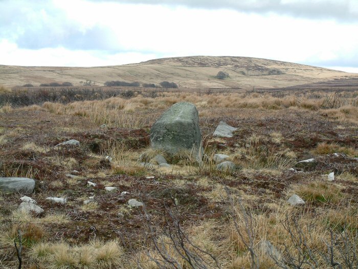
Heading East from Black Coppice Cairn towards Round Loaf, the upright stone appeared on the horizon. The plateau on which it stands to the North of Hurst Hill had been badly burned last summer and most of the vegetation had been removed exposing the peat layer which was now eroding.
The site consists on 1 upright stone (a rare feature on Anglezarke) and the possibility of others emerging through the peat.
Views of the surrounding landscape are superb from here, with Great Hill to the North East, Round Loaf to the East, Winter Hill to the South and the Lancashire plain to the West.

Looking East towards Round Loaf
Looking North East towards Great Hill


Looking South
The Proceedings of the Prehistoric Society No 61, 1996 pp 135 & 145
Page 135
“Is a substantial linear feature of no obvious function.”
“May have been a land boundary of the kind associated elsewhere with the Neolithic / Bronze Age exploitation of upland areas.”
Page 145
“A long straight flat-bottomed earthwork which does not conform to any lines of natural drainage or local topography. There is only limited evidence for banks on either side of the ditch”
I’ve just come across the following documentation. I think it may be the latest published survey and excavation report covering the Anglezarke area.
The Proceedings of the Prehistoric Society No 61, 1996
pp 133 – 166
“Seeing the Sites : Survey and Excavation on the Anglezarke Uplands, Lancashire”
By Christine Howard Davis
With contributions by
M. Bain, H. Bamford, B. Barnes, R. H. Leech & J. Quartermaine

Cap stone of the chambered cairn looking West.
A brief history of Anglezarke including a defination of the place name.
A new web site, looking at archaeological site around Chorley.
The chairman has had an interest in the prehistoric sites on Anglezarke moor for most of his life.
Note :- The exact location of this site cannot be guaranteed as it does not appear on any O.S. maps.
-----------------------------------------------------------
This site looks very similar to Black Coppice Chambered Cairn but still buried with a similar sized cap stone fully visible but only a small gap visible of the possible chamber.
Unfortunately the photograph I took came out corrupted. This may have been the cold getting to it internals or something else !!
I suggest this site is seen at its best during the winter months as summer vegetation will obscure it.
Note :- The exact location of this site cannot be guaranteed as it does not appear on any O.S. maps.
-----------------------------------------------------------
I stumbled across this whilst looking for Black Coppice cairn.
This feature consists of an arc of stones which may form a complete circle (the remainder is still concealed under the peat), and an upright stone sitting among a collection of stones that may have formed a cairn.

Site in context with the surrounding landscape.
Great Hill on Wheelton Moor in the distance.

Side view of the upright and possible cairn. Looking North East.

Side view of the upright and possible cairn. Looking South West.

The upright stone showing what may be left of a cairn. Looking North West.

The upright stone at the centre of the arc. Looking South West

Looking down the outcropping stones – North West direction

The lower arc of out cropping stones looking South – East
Note :- The exact location of this site cannot be guaranteed as it does not appear on any O.S. maps.
-----------------------------------------------------------
This stone just outcropping from the surrounding peat and vegetation shows a curious curvi-linier marking similar to the playing card shapes associated with Roman forts ?


Note :- The exact location of this site cannot be guaranteed as it does not appear on any O.S. maps.
-----------------------------------------------------------
This chance find was on the top of Hurst Hill surrounded by many other stones / boulders outcropping through the eroding peat.
When I put my compass next to the grooves to give a feeling of size, I was surprised to see that they aligned precisely North / South.

As can be seen on the image, the grooves align exactly North / South.


Boulder showing 2 deeply cut parallel grooves.
The Anglezarke Moor Group has been created to collect together previously known sites and more importantly, new features that are appearing out of the eroding covering of peat.
The perimeter of this area have been defined using where possible landscape and are :-
West – Stronstrey Bank escarpment.
East – A675 (as it runs along the “valley” bottom between Turton & Anglezarke Moors)
South – The road from Belmont to Rivington village (as it runs at the base of Rivington Moor escarpment)
North – Dean Black Brook. (Separating Anglezarke from Wheelton Moor)
Over time it may be decided that some of these should not be considered in “isolation” but may be linked to other sites in the surrounding area.
As features are rediscovered they probably won’t appear on any maps and so may not be named. In cases like this I suggest they are named Anglezarke Misc 1, 2 etc until a proper naming convention is found.