Local photographer and regular TMP contributor, Nicola Didsbury told me about this site, she had been told that there was once a stone circle there which had been destroyed and all but two of its stones had been thrown into the River Eden.
See Nicolas notes here
megalithic.co.uk/article.php?sid=11486.
Access to the stones is via the approach road to Winderwath gardens. The entrance to Winderwath was until recently on the A66 however since the recently completed by-pass has been built you need to leave the A66 at the junction for Temple Sowerby.
There are two stones here; the first stone is a large upright block of porphyritic stone which stands beside the road. The second stone appears to be similar in composition and lays prostrate behind it, hidden by the fence and dense hedge. There are also a number of small stones which have the appearance of a field clearance.
I have been unable to find any reference in both the antiquarian and the modern literature to a stone circle or standing stones in this area; however this does not mean that this is not a genuine prehistoric site. Eleven kilometers to the west of this stone is the massive standing stone of Holme Head which was until recently unrecognized, which just goes to show that even in areas where extensive surveys have been performed it is still possible to find new sites.
I took the short walk here from Kirksanton.
This pair of beautiful stones on the edge of a stoney field appear to point to the Whicham valley and a possible route into the central fells via the Duddon valley and the Wrynose pass.
More importantly, they should also be seen as part of group of coastal monuments that include the nearby lost circles of Kirkstones, Hall Foss and Annaside. Beckensall in Prehistoric Rock Art of Cumbria quotes J. Ecclestone (1872) as reporting ‘six stone circles, a Giants Grave, and a huge cairn south of the Esk.‘
In his recent book Prehistoric Monuments of the Lake District, Tom Clare reports a buried landscape around these stones including what appears to be a ring of pits around the stones and other cropmarks which include ‘timber henges or roughly circular palisaded enclosures with internal and concentric pits.‘
I find it rather sad that these stones are all that’s left of this once magnificent landscape, but then again at least they are still there and have not been destroyed, unlike many of our lowland prehistoric monuments.
Access is very good. It’s possible to park at the field gate beside the level crossing and then it’s just a short walk down a bumpy field margin footpath.


The single cup mark on the northern stone with Black Combe in the background.
So I returned [from Lowther Hall] 4 mile back to Peroth ... and came by a round green spott of a large circumfference which they keep cut round with a banke round it like a bench; its story is that it was the table a great Giant 6 yards tall used to dine at and there entertained another of nine yards tall which he afterwards killed; there is the length in the Church yard how farre he could leape a great many yards; ...
Travel book, manuscript record of Journeys through England including parts of the Lake District, by Celia Fiennes, 1698.
Taken from the very excellent website
Guides to the Lakes
geog.port.ac.uk/webmap/thelakes/html/simpson/smp3fram.htm
At one stage, the stone leaned markedly, rather than standing fully erect, and was known locally as “The Dean”. This name apparently had something to do with an elderly dean of the island who had recently married a woman very much younger than himself
Jersey in Prehistory
Mark Patton
La Haule Books
1987
The stone used to be the largest in the island (2.5m) until it was attacked by a farmer with a sledgehammer.
“This action, amazingly, was not at that stage illegal but he was forced to abandon his rape of the island’s heritage because of massive outcry”
Jersey in Prehistory
Mark Patton
La Haule Books
1987
People, Place and Polity in the later Third Millenium BC
Friday 18th – Sunday 20th April 2008
A major international conference organised by the Prehistoric Society and Bournemouth University Centre for Archaeology, Anthropology and Heritage
This conference will address the concept of the Chalcolithic in British archaeology. Our continental colleagues have long used the term to augment their three-age system. Why has the term not been adopted so universally in Britain and Ireland? Is it relevant to our islands? Or is it a misnomer?
Read about it here
berwick-advertiser.co.uk/news/planners-reject-wind-farms.3923173.jp
Hobs wonderful account of the rediscovery of the Amerside carvings
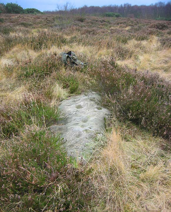
This is a lovely little outcrop, in a small clearing and beside a small pool that looks like it is regularly used by deer.
The panel consists of 2 main motifs one roughly oval and one rectangular. There is a third, small motif which we were unable to locate
The panels were uncovered, cleaned and recorded.
I was particularly struck by the rectangular panel with it’s concentric grooves. Rectangular panels enclosing cups are not a common motif in British rock art. However there are three such motifs, this one, Dod Law and Chatton all within a relatively small geographical area. Not sure what it all means but they are lovely things to see and feel.
This site is a lovely clearing in the forest. The site is raised and roughly circular and has signs of quarrying on its edges. To one side of the raised area is a substantial upright stone, judging from the fluting on the stone it has been stood upright for a long time. Upon lifting some of the turf I found a simple eroded cup and ring, on further investigation we also found another very weathered cup with a possible ring.
There was some debate as to whether these carvings represent the site recorded as Amerside Law 2.
Amerside Law Panel 1
This panel is located in a small clearing within a densely packed conifer plantation. When Andy and Hob rediscovered this panel it was covered in a thick, dense mat of woodland crud which they spent a considerable amount of time clearing.
The panel is located on a rock outcrop; views from the panel are currently non-existent. If the plantation was removed, the main viewshed would be across the Till Valley to the distant Cheviot and surrounding hills.
The carvings themselves are much worn and were described by Stan Beckensall in the 1970’s. It was not possible to locate all of the features included in Stan Beckensall’s drawing of the panel. It appears that during the intervening years, a section of the carvings have disappeared completely, possibly due to damaged by forestry vehicles during the planting of the conifers.
Initially the carvings were quite difficult to make out, tracing their outlines with water helped bring the panel to life revealing a complex set of motifs. For me, one of the striking features of this and other panels is the asymmetrical nature of a number of the motifs. By this I mean that you have a large channel or double channel enclosing a number of cups, however, the cups are not evenly distributed but occur in one sector of the enclosed area or may even lay across the enclosing channel. This has always interested me, it is obviously a deliberate act and my personal opinion is that this strengthens the case for attaching a specific meaning to the motifs as opposed to purely an abstract design.

An old school version of Amerside Panel No.1 with the carvings highlighted with water.
Not quite up to Hobs lush photo but it gives you an idea of what’s there.

Looking north east-ish from the stone across Eston Moor to the Nab

Cet ancien monument, ces pierres, ces autels,
Ou le sang des humains offert an sacrifice
Ruissela, pour Dieux qu’enfantiot le caprice;
Ce monument, sans prix par son antiquite...
written to commemorate the movement of the monument from Jersey to Henley upon Thames
Various useful WWW links for Malta
maltesering.com/
The Maltese webring with all sorts of useful stuff
heritagemalta.org/
Heritage Malta’s website. Lots of information plus that all important shop where you can book your place for a tour of the Hal Saflieni Hypogeum – BOOK EARLY!
atp.com.mt/
The excellent Maltese Public Transport Association website. Includes timetables and specific information on how to get to historic sites.
web.infinito.it/utenti/m/malta_mega_temples/index.html
Daniel Cilia’s superb website
geocities.com/RainForest/3096/ungul.html
C. Savona-Ventura’s articles
geocities.com/athens/agora/5685/index.html
Dr. Anton Bugeja’s excellent website
geocities.com/maltatemples/home.html
Mario Vassallo’s Sun Worship and the Megalithic Temples website.
weathermalta.net/websites/mariovassallo/3/
Another interesting website from Mario Vassallo on the Planning and layout of the Maltese temples
otsf.org/
OTS Foundation website
cisklager.com
Maltas Premier Beer – apparently it’s bottom fermented, that explains a lot!
I visited Long Meg for the winter solstice sunset on the 22.12.07 and noticed that someone had attacked Long Meg with a sharp object causing a series of peck marks and in the process chipping of a small amount of stone.
A great way to spoil a lovely day.

22.12.07
Arrow indicates damage caused by some lowlife pecking Long Meg.

Looking down on the site from the south.
The stones are between the boulders on the roadside and the wall on the left of the picture.
The chimneys of the Shap Limestone plant are visible in the distance.

This is an easy site to visit. Travelling south from Shap on the A6 take the first left onto the M6 link road and then take your first right onto the minor road to Orton.
As you turn onto this road you will see a row of boulders bordering an area of rough moorland. The site is just beyond the boulders.
Tom Clare reports this site as a group of stones that ‘appear to form a circle’. I was unable to fully trace Mr Clare’s full circle but there is a definite arc of stones at the southern end.
The ‘circle’ is situated on the side of a gentle rise with the views restricted to the south by the rising ground. I was fortunate enough to visit on a cloudless, frosty Midwinter day and the views to the east west and north were beautiful, looking over the great limestone plain to the Pennines and the moon rising over Cross Fell and then looking northwards over Shap with the Skiddaw massif just visible in the far distance, the vista to the west takes in the fells around Haweswater and High Street.
Whether this is a genuine prehistoric ring or not, it’s well worth a short visit, if only to take in the views.
To add to the quotes by Paulus here is some more of what William Greenwell had to say about Seal Howe.
A cairn at the head of Oddendale, called Seal Howe, was also examined; some other cairns very much destroyed are in the immediate vicinity, and about 300 yards to the west is a double circle of stones. The place is traditionally spoken of as the site of a great battle, and there are extensive mounds of stone and earth thrown up as if for the purpose of entrenchment. Between the cairn and the circle there runs an ancient road which, following the high ground as much as possible and avoiding the valleys, was one of the main lines of route from Clifton to Borrow Bridge...
The position which this cairn occupies is very striking, and the scene, as viewed on the afternoon when the mound was opened, was one not easily to be forgotten by the explorers. As the sun lowered towards the mountains in the west a flood of golden light was thrown upon the moorland up to our very feet, turning the purple of the heather with a richer hue, and adding a more than common warmth to the red and grey lichen-covered boulders of Shap granite which lie like flocks of sheep upon the turf. Clouds, themselves aglow with the level rays of the setting sun, threw broad patches of shade upon the illuminated ground, and made the sunshine more vivid by the contrast. To the east was the broad and heavy range of Cross Fell, fronted and broken by the three sharp cones of Murton, Knock, and Dufton Pikes, and over which,at its northern end, the far distant mountains of Cheviot were just to be distinguished. Stretching down in the direction of the broad valley of the Eden, and converging in the wooded hollow in which lies the village of Crosby Ravensworth, the spire of its church just peeping from out the trees, were the tributary valleys of Oddendale and Crosby Gill. The former, with its grey stone walls and clumps of trees, marking the site where the slated roof and curl of blue smoke showed that some statesman had his home ; the latter, the deep rocky gorge of the Lyvennet as it speeds from its sources on the moor, its sides clothed with natural wood, the representative of larger forests, where the ancient Briton had hunted the stag and boar, and where in later days Sir Lancelot Threlkeld, a local magnate of Tudor times, had his hunting-lodge.
On the south, Ravenstonedale and Tebay Fells closed the view, deeply furrowed by precipitous side-valleys winding far away into the bosom of the hills, and coloured with green and purple and gold under the light and shadow of sun and cloud. Westward over Shap, with its scattered monoliths once forming an avenue and circle, and its ruined abbey, alike companions in decay, the eye, overlooking the intervening valleys of Wet Sleddale and Swindale, passed across the great hollow in which lies Hawes Water to the flat-topped ridge of High Street, relieved at one place by the sharp point of Kidsty Pike. Further on to the north-west was Saddleback, the ancient Blencathra, with Skiddaw just seen beyond it ; and then Carrock Fell, and flatter land carrying the eye along almost
into Scotland.
British Barrows. A Record of the Examination of Sepulcheal mounds in Various Parts of England
By William Greenwell, M.A. F.S.A
1877
In his 2007 book, Prehistoric Monuments of the Lake District, Tom Clare states that,
in 1972 the author was assured by a resident that he had not built it. However thirty years later the story has changed.
This site was indentified by Tom Clare in his excellent 2007 book, Prehistoric Monuments of the Lake District.
The late Archdeacon Wilberforce, who was at that time Rector of Burton Agnes, had come over to make an archdiaconal inspection of the Church, when he met an old parishioner in the Church yard. The Archdeacon said to him,
” Well ! my good man, can you tell me anything about this wonderful stone ?
” Na, I can’t say as how I can,” was the answer.
“Why ! you’ve lived here a great many years, and surely you must know something about it,” said the Archdeacon.
” Na, I doint,” was the laconic reply.
“Well then if you don’t know anything about it and can’t tell me anything about it,” said the Archdeacon, ” you can tell me what they say about it.”
” Whoy ! yaas, I can tell you what they say about it,” was the information derived this time.
” Come then, my friend, let me hear what they do say about it,” said the Archdeacon.
” Well ! ” replied our Rudstonian friend,
” they says it was put up here to com-memorate a great vict’ry ‘tween Danes and Roman Cath-licks.”
Rudston A Sketch of its History and Antiquities
by
the Rev. P. Royston.
1873.
Taken from
Publications of the Folk-Lore Society
County Folk-Lore Vol VI
Examples of printed folk-lore concerning the East Riding of Yorkshire
Collected and edited by
Mrs Gutch
Roulston Scar, Hambleton Hills. In some parts the rock is perpendicular, and has the appearance of an irregularly built castle. The foreground of this for fifty or one hundred yards is covered with massive blocks of stone, evidently thrown off by some convulsion of nature. On the side of the rocky wall is a fissure opening into a small, narrow cavern, called the Devil’s parlour, from the common disposition to attribute what is at once gloomy and marvellous to infernal agency, especially when in any way connected with heathen worship, of which there are not wanting traditions in the immediate vicinity.
For instance, the vale below dividing Roulston Crag from Hood Hill is called ’ The Happy Valley’ but the intermediate distance is less auspiciously named ’ The Devil’s Leap! for which this reason is given by the village oracles. The Happy Valley was a famous retreat of the ancient Druids, who without molestation or disturbance had for centuries practised their incantations upon the poor deluded inhabitants.
When the first Christian missionaries visited Yorkshire, they sought out the hidden retreats of Druidism, and one of them had penetrated the Happy Valley to the no small dismay of the Druidical priest The ancient Britons listened patiently to the statements of the Christian missionary, weighed the evidences in their own minds, and were perplexed as to their future procedure. In this dilemma a conference was appointed, in which the advocates of Druidism and Christianity were to meet in public contest in order to decide which of the two systems had the best claim to their worship and submission. The meeting, as usual, was appointed in the open air, at the foot of Roulston Crag. The intellectual assailants met, and the devil, in the garb of a Druidical priest, came with the worshippers of Baal. The Evil One placed his foot on one of those mountain rocks, and being foiled in his arguments by the powerful reasoning of the missionary, flapped his brazen wings and fled across the valley with the stone adhering to his foot, the heat of which (they say) melted a hole in the top, until he came to the ridge of Hood Hill, where he dropped the massive block, leaving the missionary the undisputed master of the field. This account will of course be received as a legend, but it is a matter of fact that a large stone weighing from sixteen to twenty tons of the same rock as Roulston Scar, is deposited on the ridge of Hood Hill, bearing a mark on the top not unlike a large footprint.
Vallis Eboracensis : comprising the History and Antiquities of Easingwold and its Neighbourhood.
By Thomas Gill.
London 1852.
Blagged from
County Folk-Lore.
Publications of the Folk-lore Society
1899.
At Mow Cop is a rude upright pillar, called the Old Man at Mow, and believed by the country people to have been an idol, once the object of worship. It is needless to add that the British word Maen signifies a stone, and that the prefix ” old ” or ” elder,” is merely a Saxon epithet to denote its antiquity.
From
Druidical Remains in Yorkshire.
by
J. K. Walker, D.D.
In
The Gentleman’s Magazine Library:
Being a classified collection of the chief contents of The Gentlman’s Magazine from 1731 to 1868
Edited by
George Laurence Gomme, F.S.A.
One of the three monuments, which is on rising ground close to the farm of West Mulloch, I found in such a dilapidated condition as to render an accurate survey impossible ; but from it I saw another about half a mile further in an oat-field upon lower ground. While I was engaged in measuring it the rumbling sound of thunder beyond the distant hills warned me to be expeditious, and as the storm-clouds rolled over the mountain tops with great rapidity, and rain began to descend, I thought it prudent to quit the exposed open country and seek shelter in a cart-shed of Esslie Farm. For several hours, Louder and louder than mortal gunpowder The heavenly artillery kept crashing and roaring, The lightning kept flashing, the rain too kept pouring,
but long before the storm ceased I was compelled to commence my return journey to Banchory Station, which I reached footsore and drenched to the skin. This was the most severe thunderstorm of the season, and many fatal casualties occurred in Scotland on this day.
The long stone filling up the space between two erect stones of the outer ring, exists both in the West Mulloch and Esslie monuments.
The Rev. W. C. LUKIS, F.S.A.
From
PROCEEDINGS OF THE SOCIETY OF ANTIQUARIES OF LONDON.
NOVEMBER 29, 1883, TO JULY 2, 1885-
SECOND SERIES, VOL. X.
LONDON:
PRINTED BY NICHOLS AND SONS, FOR
THE SOCIETY OF ANTIQUARIES,
BURLINGTON HOUSE.
August 6. The sixth monument I surveyed is situated in Aberdeenshire about two miles from Dyce Junction, on the line of railway to Inverness, on high ground a short way from some extensive granite quarries. It stands in a clump of trees, and is concealed from view until you are quite close to it. A low wall sweeps round a part of it, and it is a favourite resort of holiday folk. It goes by the name of ‘the standing stones of Dyce.’ This monument has been more injured than those of Auchincorthie, for the cairn has been entirely removed, and the area has been so excavated that it forms quite a basin. In one part a few stones of an inner ring remain, and are so much overgrown with broom and grass as to be scarcely visible. Its original construction “was evidently of the same character as those already described; and here again we find the enigmatical broad stone in the gap between two lofty erect stones of the outer circle. The broad stone has fallen inwards and rests in an inclined position upon one or two small stones, which probably formed part of the inner ring. The stones of the outer ring are of very unequal heights; the tallest being 9 feet 7 inches and the shortest 3 feet.
The Rev. W. C. LUKIS, F.S.A.
From
PROCEEDINGS OF THE SOCIETY OF ANTIQUARIES OF LONDON.
NOVEMBER 29, 1883, TO JULY 2, 1885
SECOND SERIES, VOL. X.
LONDON:
PRINTED BY NICHOLS AND SONS, FOR
THE SOCIETY OF ANTIQUARIES,
BURLINGTON HOUSE.
Lowick. About three miles wast of the village is Renting Lynn. ... A cataract, 18 feet high, the sounds of which can be heard a distance of 200 yards . . . near this spot is a well, in which, according to an improbable tradition, King James of Scotland washed the blood off his hands after the battle of Flodden.
History, Topography, and Directory of Northumberland, Tyneside Division.
J. Bulmer
1887
This goblin-haunted mound was elevated several feet above the moorland, and was covered with heath. Under this was a great collection of sandstones loosely thrown together, which had been gathered from the neighbouring surface. On removing them, a circle of broader and larger stones appeared set on edge, in number 25, or, allowing for a vacant place, 26. Within this was another circle, composed of smaller stones set edgeways, in number 25 or 26 ; and the centre of the inner space was occupied by a rectangular kist, composed of four flagstones set edgeways. The sides of this cyst pointed east and west and north and south ; the greatest length being from east to west. On arriving at this fortunate result of our labour, our expectations were a little raised as to what might follow. But within the kist were no urns, no bones, no treasures of any kind, except a tail-feather from some farmyard chanticleer. The countrymen said this place of ancient burial had been opened many years ago, and that then gold was found in it. It seemed to us that it must have been recently visited by a fox.
Considering the position of the kist, set with careful attention to the cardinal points; the two circles of stone; the number of these stones, which if completed appeared to be 26; it seemed not unreasonable conjecture, that the construction contained traces of astronomical knowledge, of the solar year, and weekly periods. I dare not confidently affirm this. Was this a relique of an early British chief, or of a later Scandinavian warrior ? for such circles have been raised in Scandinavia and the Orkney Islands by the Northmen, and this is a district which the Northmen colonized. A similar circle of stones occurs at Cloughton near Scarborough.
The Rivers, Mountains and Sea Coast
By
John Phillips, F.R.S.
LONDON
1853.
Addleborough. Tradition tells of a giant who was once travelling with a chest of gold on his back from Skipton Castle to Pendragon ; while crossing Addleborough he felt weary, and his burden slipped, but recovering himself he cried
’ Spite of either God or man,
To Pendragon Castle thou shalt gang ! ‘
when it fell from his shoulders, sank into the earth, and the stones rose over it. There the chest remained, and still remains, only to be recovered by the fortunate mortal to whom the fairy may appear in the form of a hen or an ape. He has then but to stretch forth his arm, seize the chest, and drag it out, in silence if he can, at all events without swearing, or he will fail as did that unfortunate wight, who uttering an oath in the moment of success, lost his hold of the treasure, and saw the fairy no more as long as he lived.
A Month in Yorkshire.
By Walter WHITE.
London
1858.
Taken from
PUBLICATIONS OF THE FOLK-LORE SOCIETY
COUNTY FOLK-LORE
XLV/ 1899.
Bridestones. Picturesque pillars of rock on our moors, particularly near Blakey Topping, at which love and marriage ceremonies were practised in former times, as these rites of the ancient Britons are recorded to have taken place near their cromlechs or altar- stones. Formed by long aqueous and atmospheric action dispersing the softer parts and leaving the harder standing (such being the cause assigned for their appearance), one among the shapes has been likened to a gigantic mush- room, being 30 feet high, 20 feet broad at the top, on a stalk only three feet broad in one part and seven feet in another.
A Glossary of Words used in the Neighbourhood of Whitby.
By F. K. ROBINSON of Whitby.
London MDCCCLXXVI.
Taken from
PUBLICATIONS OF THE FOLK-LORE SOCIETY
COUNTY FOLK-LORE
XLV/ 1899.
Roseberry. Towards the weste there stands a highe hill called Roseberry Toppinge, which is a marke to the seamen and an almanacke to the vale, for they have this ould ryme common,
’ When Roseberrye Toppinge weares a cappe
Let Cleveland then beware a clappe.‘
For indeed yt seldome hath a cloude on yt that some yll weather shortly followes yt not, when not farre from thence on a mountayne’s syde there are cloudes almoste contynually smoakinge, and therefore called the Divels Kettles, which notwithstandinge prognostycate neither good norbadde ; . . . yt hath somtymes had an hermitage on yt, and a small smith’s forge cut out of the rock, together with a clefte or cut in the rocke called St. Winifryd’s Needle, whither blynde devotyon led many a syllie soule, not without hazard of a breaknecke tumblinge caste, while they attempted to put themselves to a needlesse payne creepyng through that needle’s eye.
A Description of Cleveland in a letter addressed by H. Tr. to Sir T. Chaloner. [From the MS. Cotton. Julius F. VI., p. 431.] Printed in the Topographer and Genea-
logist, edited by John Gough Nichols. Vol. ii., pp. 405-430. London 1853.
Lifted from
PUBLICATIONS OF THE FOLK-LORE SOCIETY
COUNTY FOLK-LORE
XLV/ 1899.
“I the North Riding am for spaciousness renown’d
Our mother Yorkshire’s eld’st.”
POLY-OLBION. The Works of Michael Drayton, Esq. In four volumes.
London MDCCLIII. Vol. II..

Looking East from the tombs over St. Pauls Bay. The arrow indicates the location of the Bugibba Temple.
The tombs at Xemxija are significant for a number of reasons. They were excavated by Evans in the 1950’s and yielded a whole host of material. The majority of the finds dated to the Ggantija phase but there were also some sherds of Tarxien pottery and some later Bronze Age burials were also found along with some axe amulets. Many animal bones many were also found here giving us a good idea of what animals existed on the islands during the Neolithic. Bones found included sheep, goats, pigs, cattle, horse, dog, cat, deer, rabbit and hedgehog.
The tombs themselves are not too difficult to find and you can drive to within a dozen yards of them. To reach the tombs you need to turn off the main road (route 1) at the roundabout at the top of the hill at Xemxija, there is also a church on this roundabout. Turn into Xemxija and drive past the derelict hotel complex to the top of the village. The tombs are beside Triq bil-Preistorja which is the last road at the top of the hill. Park on this road. The tombs are at the top of the small rise about half way along the road. When we visited we drove to the end of the road and then went mooching around the fields on the hillside until a very nice lady pointed us in the right direction.
A word of warning, You need to keep your wits about you in this area . It seems to be very popular with hunters. I used to drive past this hillside on a daily basis and there were always at least a couple of four by four vehicles parked on the hillside.
The tombs themselves are basically just holes in the ground. I stuck my head into most of them and was greeted by the hum of wasps or bees in three of them which kind of put me off going any further into the tombs. What I did find remarkable was that the tomb builders had picked a horizontal surface to tunnel into. The limestone here is very hard so excavating the tombs vertically in to the bedrock must have taken a considerable effort. It would have been far easier to cut horizontally into the strata a little lower down in the Mistra valley where there are cliffs and natural caves. Which leads to the question why all the effort? What was the significance of this particular hill?
The hill is not the highest in the area but it does have good view over St Paul’s Bay and the coast beyond or at least it would have if the village were not in the way. It is possible to pick out the location of the Buggibba temple in the distant sprawling resort.
All in all the Xemxija tombs don’t offer much in the way of spectacular remains but if you are wanting to build up a picture of Maltese Prehistory and maybe understand why certain locations were chosen then it’s worth coming here, sitting yourself down and having a good look around you. One feature of the tombs is that some of them are lobed which indicates that there may be a link between the lobed nature of the caves and the similar layout of the temples.
I would never describe Malta as a pretty place then again I would never describe the Maltese landscape as boring. I’ll take interesting over pretty any time. My lad would say that it’s worth visiting the site because there are lots of huge ant’s nests and you can spend time feeding dead insects to the ants.