
fitzcoraldo
One of the three fallen stones adjacent to the tallest stone that could have made up the four poster. The weathering on the end of this stone proves it was once and upright


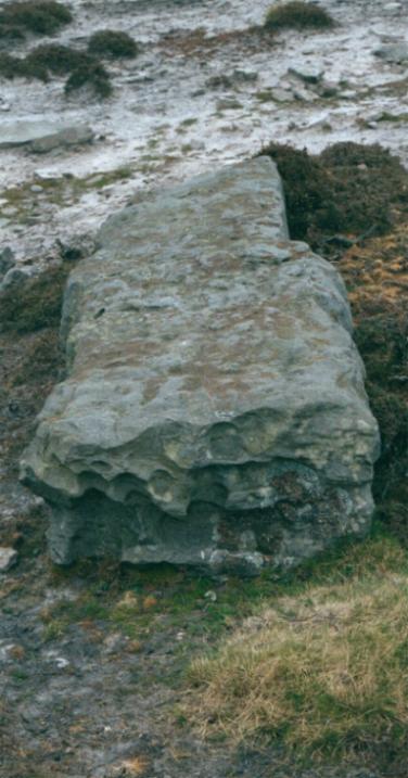
The largest of the Bridestones with the possible other three uprights in the background.

John Cross with its ancient base and later addition..bloody puritans!


This site is located on the northern edge of the North York Moors escarpment at the northern end of Raisdale.
The site is just beside the Carlton in Cleveland to Chop Gate road in a meadow beside The Lord Stones Cafe.
The site consists of at least three small round barrows one of which is a cairn circle with large prominent stones.
The are also a couple of standing stones on the site. The site has had a lot of disturbance, not least with the building of the cafe. Several large stones have been incorporated into the fabric of the building that may or may not have come from the site.
The site itself is a nice green meadow with nice views across the vale of Cleveland and beyond.
The cairn circle is behind the cafe is on the path of the Cleveland Way and a couple of metres from the road, it is approx 6m across. 4m to the north of this is a barrow that has a turf covering with a few stones ‘poking through and then another 20m North of this is another barrow also turfed and also with a couple of small stones showing.
A few metres to the east of the cairn circle is a single standing stone.
There is another large standing stone on the site, this is a large rectangular block which has been dressed at some point in the past, it is marked on the OS map as a boundary stone. It is much larger than the usual NYM boundary stones so may have been adapted from an existing standing stone.
If you follow the Cleveland Way East from the site you will climb up onto Cringle Moor where you will see two things;
1.A most excellent 180 degree panorama with views to, starting from the west and moving east, Ingleborough and Whernside, Stainmoor, Cross Fell, Weardale, The Penshaw Monument (on a very clear day), Hartlepool, Teesmouth, Upleatham and the sea beyond, Roseberry Topping, Park Nab and Turkey Nab.
I know all this because there is a plaque there that told me so.
2. The large round barrow of Drake Howe NZ539029. A big-un measuring in at 25m across.
All in all, an nice and accessible site.
If you do go up to Cringle Moor, dont forget to wrap up warm.
“This is the system the system of earthworks on Fylingdales Moor at NZ905022 consisting of triple trenches in which stands one or two stones, the most prominent of which bears the name Old Wifes Neck. According to Elgee, an entry in the Gentlemans Magazine for 1857 speaks of hundreds of flint arrow heads having been found below these fortifications in Biller Howe Dale. If this is correct, then this is the only place where any sign of war during the Bronze Age or even earlier.”
The North York Moors, An Introduction
Stanhope White
1979


A farmer returning home late one night heard music coming from Willy Howe. On investigation he found a door which neither he or anyone else had seen before.
He peeped inside and saw a table groaning with food and a bunch of hobs making merry.
The hobs invited him in and offered him a drink. He took the drink and then dashed off with the cup. The hobs gave chase but as soon as he crossed the first beck on his route they gave up and returned to their feast.
On arriving home he saw that the cup was a fabulous gold vessel.
He presented this cup to King Henry I who later passed it on to his brother-in-law King David of Scotland
With reference to the previous folklore post.
“In the 1930’s an old farmer in the Roppa area, used the phrase ‘He wur swearing like Billy Norman coming out of the fog on the moor’ “.
The North York Moors, An Introduction
Stanhope White
1979


A Local saying
Cleveland in the clay,
Bring two shoes, carry one away.
A a, flea fly, a magpie an bacon flitch
Is t’ Yorkshireman’s coit-of arms.
An’t reason they’ve chozzen theaze things soa rich
Is becoss they hev all special charms.
A flea will bite whoivver it can-
An soa’ mi lads, will a Yorkshireman;
A fly will sup wi’ Dick, Tom and Dan-
An soa i’gow will a Yorkshireman;
A magpie can talk for a terrible span-
An soa an’ all, can a Yorkshireman;
A flitch is noa gooid whol* it’s hung, ye’ll agree-
No more is a Yorkshireman, doan’t ye see.
*till
Folk tales of Yorshire
H.L. Gee
1952

Driving along the Kildale to Commondale road I noticed this fella standing on whats called by the OS, a cairn. It’s a single stone on a raised platform, more of a tumulus than a cairn, but who am I to argue with the OS.
I traipsed up to investigate, its only 2 minutes from the road.
The stone is been standing there a long time judging from the weathering on his top. He stands approx 1.6m X 0.6m.
It’s not a cross stone and doesn’t appear on the map as a boundary stone.
There is some graffitti on the stone which says ?“B died here”
Some party that must have been.

Captured on a late autumn day, the lichens on this fella put me in mind of rock art


“Only the stone base remains of John Cross, a wayside cross of early christian origins, probably destroyed by puritans in the 17th century. The stone which now fits in the base is of a later date and is a boundary marker between the parishes of Sneaton and Fylingdales.”
“Walk The North York Moors”
Brian Spencer
1991
Puritans eh!
The Old Wife’s Neck is two standing stones incorporated into a linear earthwork. To get there, start at the Maybeck Forest Walk car park and then hike back up the road to New Maybeck Farm, the scruffiest farm you ever saw! Turn right here and follow the path along and past the woods until you come to the moor and the sad remains of John Cross. Turn right and follow the path parallel to the forest.
You cannot see the stones until you arrive at the double dyke earthworks, then you will see them on your right.
The long linear dyke is orientated East – West and is approx 1km long.
The stones on on the western end and are within the dyke feature.
There are two stones, the first is approx 0.9m high and the second 1.2m high.
Observed from either the east or west the larger stone appears not unlike a human head and neck although from the north or south it appears to be a squat ‘L’ shape.
The stones are orientated to a pair of mounds on the western horizon ? Foster Howes. The view to the east is obscured by the rise of the hill and the dyke feature. If you walk a few meters up onto the dyke you can see across to Robin Hood’s Bay and the sea.
You can also see Standing Stones Rigg from here ( the site of Ramsdale Stone circle).
This is a lovely bleak spot, the sound of the wind blowing through the nearby forest reminds me of the sea and you can hear the whistles of the steam trains coming over the moors from Goathland.
If you want to make a nice circular walk of your visit you can follow the path right around the margins of the forest and take in Louven Howe, Lilla Cross which is on Lilla Howe, Ann’s cross also on a mound (two examples of christianised barrows) Foster Howe, Robbed Howe, and the igneous Cleveland Dyke.
Alternatively, if you’ve got the kids with you and just fancy a short circular walk, continue along the path from the stones and then cross into the forest on the marked path, when you come to the ruins of John Bond’s sheep house take the right hand fork. This will take you along the Blea hill beck. Its a lovely path following the beck . It criss crosses the Beck and takes you through lovely glades of daffodils and primroses. The valley is absolutely gorgeous at this time of year. The path brings you back to the car park.
Lovely!
Wade’s Stone (South) is visible from the A174 at East Barnby. There is no public footpath. We parked opposite the entrance to the Training Centre (on Wade’s Lane) and accessed through the gate that leads to a path that runs beside the Training Centre.
Wades Stone is on a slight rise in the field in front of you. His vital statistics are similar to his brother 1km away 2m X 1m. He is not as weathered as his brother but does have one deep ?libation channel running from top to 1/4 way down.
Wade is supposed to be the local giant, his name crops up all over the North Yorkshire Moors. The Roman road that runs onto Wheeldale is known as Wade’s Causeway. This implies that the name of Wade came after the Romans had left our shores and vanished from the folk memory. Many of the sites attributed to Wade are in areas that were settled by the Danish vikings. It does not take a great leap of faith to transform Wade to Wodan.
That’s my theory for what it’s worth.
Situated in a field on Goldsborough Lane.
Turn off the A174 at the East Barnby / Goldsborough cross road.
The stone is in a field on your left approximately one kilometer down Goldsborough lane.
The field is next to a small wood and at the entrance to Brockrigg Farm. Within a kilometer of the stone there are 3 round barrows, a Roman signal station and the other Wade’s Stone.
Wades stone stands about 2m tall and is roughly square with 1m wide faces. The top of the stone is weathered with deep ?libation channels running about 1/4 way down. The farmer had just been muckspreading when me and Timmo visited and the stoney chap was wearing a coat of crusty shit down one face.
