Mike Haigh’s Tale of Wade from Northern Earth
fitzcoraldo
Graeme C’s wonderful site including pages covering Brow Moor & the fire
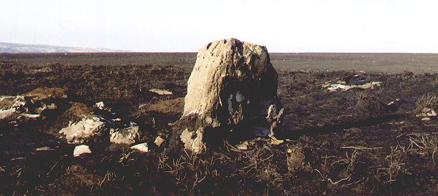
This stone is approx 2m high and 1m broad. The weathering on the top of the stone indicates it’s antiquity. It has been damaged by the fire and will no doubt suffer further damage once the frost begins to permiate the cracks caused by the intense heat of the fire.
There is another large standing stone on the moor which is taller and narrower, but the Mighty Graeme C informs me that this is a recent addition to the moor’s topography.
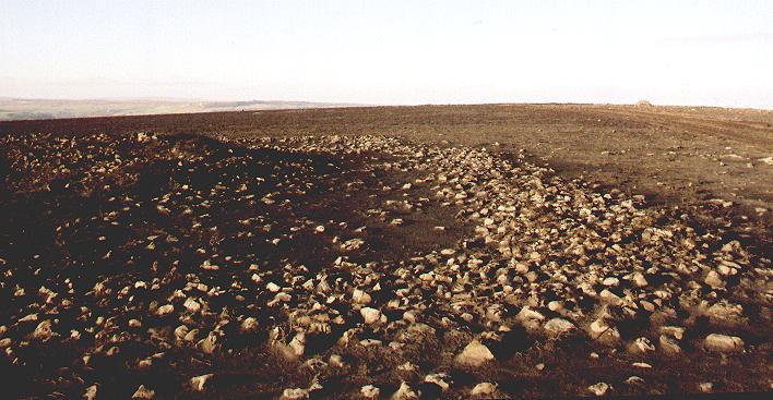
This ring cairn is a low lying feature in the landscape, it is composed of smallish stones and is approx 12m in diameter. I was unable to capture a decent photo of the feature as there appears to be no banking. I have posted a picture of a standing stone that sits on the margin of the cairn and appears to be part of the monument, possibly a headstone.


If rock art is a Jazz thing then this is Coltrane’s rock! – deep grooves, deeper cups and heavy pecking.


The cups on the upper surface of this rock were known but following the fire a lot more of the rock was revealed. I was fortunate enough to witness the Mighty Graeme C peel and reveal these deep cups and grooves for the first time.

A couple of cups and an illustration of the damage done by the recent fire, the white patches are where the rock has cracked and exfoliated.


The view from the top of the largest Black Howe looking across to Freebrough Hill and the coast beyond


Isolated stone ? boundary stone, with one of the many hollow ways to Crown End in the background. The Crown End settlement is on top of the hill in the background.


The Newton Under Roseberry stone with Roseberry Topping in the background

SMR No.3292 Standing Stone
This is a standing stone beside a gate on Sandy lane. The stone is marked on the O.S. map of 1893 and stands 80cm high, 30cm wide and 30cm deep. The stone is narrow at the top, but wider at the bottom where it is 50cm wide and deep. The stone is in front of and probably supporting a low wall. The gate across Sandy Lane may have fastened to the stone. The standing stone has slight V-shaped grooves on the path side, but there are no traces of how a gate would be suspended from the stone. The stone is in fair condition.
An Archaeological Survey of the Upleatham Hills.
Peter Rowe & Stephen J. Sherlock
October 1999
I’ve walked past this stone loads of times and always assumed it was a redundant gatepost, because of this I’ve never really looked at it. Then I read Tees Archaeology’s survey of the Upleatham Hills and found it listed as a standing stone...by gum! they’re right – of course.
The stone stands on the hollow way known as Sandy Lane. As the report says it’s in front of the wall and has no obvious traces of being used as a gatepost apart from the fact that there’s a gate just by it.
It’s lovely to find this stuff on your own doorstep and just shows how you can’t take anything for granted
A shedload of 19th century one-inch to the mile OS map reprints.
Excellent value at £2.10 a pop!
“This is the more northerly of two mounds known collectively as the Black Howes. They are prominently sited on a north-west/south east ridge in open moorland at 280m O.D. The mound is largely of earth, and is 18m in diameter and 2.2m high, with traces of a megalithic kerb round it’s outer edge. One kerbstone has a benchmark. A modern marker cairn has been constructed on the highest point (now gone – fitz).
The Black Howes were opened by Atkinson, who found that both had been previously disturbed and their centres excavated. Atkinson excavated this mound extensively, and probably left very little untouched. Within the kerb he came upon ‘an imperfect barrier of stonework’ – an internal revetment wall – and at the centre he found a central cairn. On the north-west edge of the cairn he found inurned cremation which is now lost. 2.7m east of the centre was a large tripartite urn ‘quite full of bone’ accompanied by a bone pin.”
Bronze Age Burial Mounds in Cleveland
G.M. Crawford
1980
“The Percy Rigg village was first noticed by the late Mr Proud of Sleddale Farm in 1962, and excavated by R.S. Close in the following years. The site stands 880 feet above sea level at the centre of a large rectangular field about 300 fet long. There are five circular hut bases, two of them 28 feet in diameter with paved floors and walls still standing to a height of three courses of stone. Nine saddle querns and the base of one rotary quern were found.”
The North York Moors
Stanhope White
1979
Access to this lovely site is very easy, as the site sits beside the road on Percy Cross Rigg.
The site has been fenced since my last visit. I suspect the fence was erected to discourage the dickheads on two wheels from using the banks and ditches of the site to get their kicks.
There are five hut foundations here, two of which are very prominent, one having at least three courses of stone wall surviving. The site has been dated to the late Iron Age.
The area is steeped in prehistory, the mesolithic site of Highcliff Nab is less than two kms away, the long cairn, cairn cemetary and Iron age enclosure of Great Ayton Moor is one and a half kms away. The area is surrounded by Bronze Age barrows and the entrance of the most southerly hut looks over towards the site of the Commondale stone circle.
All in all an excellent spot and a good illustration of continuity of use of an area over 6 thousand years.
There is some debate over whether the local Gabrantovices tribe were a sub-tribe of the Brigantes or a division of the Parisii. I think that given the known Iron Age remains in this area, that there could possibly be a connection between the name Percy and Parisii...just a hunch!
The Black Howes are a very prominent group of barrows and can easily been seen from Smeathorns road. Access is along the ancient path, or trod, known as Quakers’ Causeway. The path runs from Aysdale Gate to Brown Hill.
We approached it from Brown Hill, the main Howe is about 1km from the road.
The first thing you notice is the wonderful views from this point, you can see the coast and lockwood Beck reservoir, but best of all are the views of Freebrough Hill.
There are also a group of prominent barrows running along a ridge on the western horizon one of these barrows is Hob on the Hill.
The first barrow you come to is large and low, approximately 1 metre high and 12 metres in diameter.
The main group of three barrows are another half a kilometer along the track. The first one you encounter is the largest. It is over 2m high and about 18 metres in diameter. There are traces of a kerb around the barrow and the southern edge is cut by a drainage channel. The barrow itself resembles many of out local barrows and has a deep depression in the top probably caused by the excavation by the prolific barrow digger, Canon Atkinson.
There are three barrows in this group and they grade in size with the largest in the east. The other two show no signs of a kerb. The group are aligned NNW-SSE.
The question is which came first, the track or the barrows? are the barrows aligned to the track or to some other object?
Whilst up there I had a look for Elgee’s stone triangle, not for the first time.
Elgee reports the triangle to be north of the Howes. I spent a good hour scouring the hill side between the path, Lockwood Beck and Spindle Bogs and came up with nothing. The hillside here is part of an intensly managed grouse moor. There are many drainage cuts, pools and shooting butts so although the moor has an outwardly natural appearence, it most definitely isn’t. I suspect any decent stone on the moor, including kerb stones and possible any standing stones have ended up in one of the many shooting butts, drainage channels or dams on the moor.
I’m not sure which Irish paper this appeared in , I was handed a photocopy of the article by a bloke who knew I was interested in such things. The article is by Sean O’Riordan and was published on 19-11-03
“Archaeologists have discovered a Bronze Age settlement and a number of other significant finds on the proposed route of a multi-million euro bypass in County Cork.
National Roads Authority project archaeologist Ken Hanley confirmed yesterday that they had made a very exciting find near the village of Rathcormac.
Pottery found on the site at Ballybrowney lower, one mile west of the village indicates it was inhabited around 1,600BC.
The site had three large enclosures and was surrounded by timber defences which were probably around 10ft high.
“A site of this type was unknown in Cork before this,” Mr Hanley said.
Inside the defences there is evidence of a home which was lived in by a high ranking person, he said. A detailed report has been sent to Duchas who will decide where to extend the excavations. Some of the 65 archaeoilogists who worked on the project believe the site could be considerably larger. The site has been preserved in case of future research.
A number of other discoveries have also been made along the 17km route of the bypass which will link Watergrasshill and Fermoy.
The oldest site uncovered is Neolithic and dates from around 3,000BC. This was discovered at Curraghprevin, just south of Rathcormac.
There archaeologists found what appeared to be a temporary enbcampment occupied by “a small hunter-gatherer unit”. Mr Hanley said pottery had been discovered in pits and these items had been sent to specialists for analysis. Cooking pits were also found during the excavations.
A total of 15 of these cooking pits or Fulachta Fiadh have been identified along the bypass route.
“The vast majority are Bronze Age and radio carbon date from 1,800BC to 800BC” Mr Hanley said.
Evidence of a Bronze Age cremation and burial was also found on a hill slightly south of the town of Fermoy.”
If you pick up a copy of the leaflet “Walking in and around Newton Stewart & Creetown” there is a route to the Cairn & 4 poster that avoids having to jump over any walls.
This is a lovely set of sites. Drive up through Bagbie onto the aptly named Blackmire Moor and use the cow byre as your starting point. Stu & I picked our way through the mud onto the field behind the byre and walked up the stone. From here were crossed over towards the tall drystone wall with the dark quarry in the background. On the other side of the wall you’ll find the cairn and a sweet four poster. The cairn appears to have two portal stones. You’ve gotta take in the whole scene and imagine that the wall doesn’t exist, the circle, the portalled cairn and the stone make a sweet little trio. Well worth a look.
I was full of anticipation before visiting this huge circle. It was to be my last contact with the Cumbrian great circles before I headed west towards the Solway coast.
I also liked the story Burl tells about how a farmer was rebuked for removing one of the stones. The farmer answered that it was only Judas that had been removed.
Burl describes the site as being divided by a hedge and spoiled in atmosphere. The hedge has now gone but the atmosphere is still spoiled.
The stones are huge but the soul of the circle has gone.
You should visit this circle to check out the megalithic engineering of setting up this vast circle on a terrace above Dumfries.
There are some lovely mineral veins in a number of the stones.
A really nice site which gives reliable directions to many sites.
Stu and I were in total agreement when it came to selecting sites that we must get to on this trip.
High Banks was a must.
Sometimes you try not to anticipate a site because it may fail to live up to your expectations but this isn’t the case with High Banks.
Drive all the way to High Banks Farm you can park and the footpath to the rocks is marked. As you climb the hill you can see the outcrop in front of you. There’s a small quarry in the outcrop and a modern plaque has been placed on a plinth.
The carvings are breathtaking and increase in complexity as you move along the rock.
As well as the multitudes of cups and lovely rings there are pecked out channels that appears more broader than what you would expect. The large carving with the grouped cups and large central cup and rings uses the contour of the rock to increase it’s visual and textural impact. It looks like a partially exposed fossil Ichthyosaur skull.
This is rock art taken to another level. This is a well designed motif which I would like to think was the work of one person, a dude/ette who got fed up with cups and rings and decided to produce something a bit more contemporary.
I bet all his mates took this piss out of him for it too!
This is one site that you should definitely see and feel.


